ماگندناو
ماگندناو Maguindanao | |
|---|---|
| مقاطعة ماگندناو | |
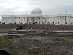
 كاپيتول ماگندناو الجديد في بولوان. | |
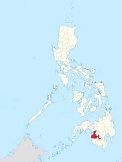
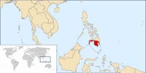
 موقع ماگندناو في الفلپين. | |
 | |
| الإحداثيات: 7°08′N 124°18′E / 7.133°N 124.300°E | |
| البلد | الفلپين |
| المنطقة | باڠسامورو |
| تأسست | 22 نوفمبر 1973 |
| العاصمة | Buluan, Shariff Aguak (التنفيذية) سلطان قدرات (التشريعية) |
| الحكومة | |
| • النوع | Sangguniang Panlalawigan |
| • الحاكم | باي مريام س. ماگندناو (حزب ناكيوناليستا) |
| • نائب الحاكم | لستر س. سينسوات (PDP-Laban) |
| المساحة | |
| • الإجمالي | 4٫871٫60 كم² (1٫881 ميل²) |
| ترتيب المساحة | رقم 22 من 81 |
| (باستثناء مدينة كوتاباتو)[2] | |
| أعلى منسوب | 813 m (2٬667 ft) |
| التعداد (تعداد 2020) | |
| • الإجمالي | 1٬342٬179 |
| • الترتيب | رقم 23 من 81 |
| • ترتيب الكثافة | رقم 39 من 81 |
| (باستثناء مدينة كوتاباتو) | |
| التقسيمات | |
| • المدن المستقلة | |
| • المدن التابعة | 0 |
| • البلديات | |
| • بارانگاي |
|
| • Districts | 1st and 2nd districts of Maguindanao (shared with Cotabato City) |
| منطقة التوقيت | UTC+8 (PHT) |
| IDD : مفتاح الهاتف | +63 (0)64 |
| ISO 3166 code | PH-MAG |
| اللغات المنطوقة | |
| تصنيف الدخل | التصنيف 1 |
| الموقع الإلكتروني | www |
ماگندناو (تگالوگ: [maˈɡɪndɐnaʊ]، بالماگندناوية: Prubinsya nu Magindanaw؛ بالإيرانونية: Perobinsia a Magindanao؛ فيليپينو: Lalawigan ng Maguindanao)، هي إحدى مقاطعات الفلپين وتقع في منطقة باڠسامورو ذاتية الحكم في منداناو المسلمة (BARMM). منذ 2014 أصبحت بولوان عاصمة للمقاطعة[4] لكن السلطة التشريعية لحكومة المقاطعة، سانگگونيانگ پانلالاويگان، تنعقد في كاپيتول المقاطعة القديم في بلدة سلطان قدرات.[5] تحدها من الشمال لاناو دل سور، كوتاباتو من الشرق، سلطان قدرات من الجنوب، وخليج إيلانا من الغرب.
التاريخ
الفترات ما قبل الإستعمارية والإسپانية
الشريف محمد كابوڠسوان من سلطنة جوهرقدّم الإسلام إلى المنطقة في نهاية القرن الخامس عشر. وبعد ذلك تزوج من أميرة محلية من قبيلة من الماراناو في إقليم مالاباڠ وماگندناو ، وأسس سلطنة ماگندناو. شكـَّل وادي كوتاباتو قلب السلطنة ولكن نفوذها امتد من شبه جزيرة زامبوانگا إلى خليج سرنگاني و داڤاو.
شن الإسپان حملات لإخضاع المنطقة طوال العصر الاستعماري إلا أنهم لم ستنكنوا من السيطرة على المنطقة حتى منتصف القرن التاسع عشر بعد أن أسسوا موقعاً في ما هو اليوم برنگاي تامونتاكا، أحد أوائل المستوطنات المسيحية في جنوب الفلپين، في مدينة كوتاباتو الحالية.
الفترة الأمريكية والحرب العالمية الثانية
تأسيس المقاطعة
تأسيس شريف كابونسوان ثم إلغائه
عنف انتخابات 2009
 حرب العصابات في ماگندناو عام 1999. |
اشتباكات ماماساپانو
إل نينيو 2016
الجغرافيا
التقسيمات الادارية
- † البلدية العاصمة
- البلدية
- ∗∗ المدينة المكون المستقلة (مرتبة جغرافيا فقد ضمن المقاطعة)
| |||||||||||||||||||||||||||||||||||||||||||||||||||||||||||||||||||||||||||||||||||||||||||||||||||||||||||||||||||||||||||||||||||||||||||||||||||||||||||||||||||||||||||||||||||||||||||||||||||||||||||||||||||||||||||||||||||||||||||||||||||||||||||||||||||||||||||||||||||||||||||||||||||||||||||||||||||||||||||||||||||||||||||||||||||||||||||||||||||||||||||||||||||||||||||||||||||||||||||||||||||||||||||||||||||||||||||||||||||||||||||||||||||||||||||||||||||||||||||||||||||||||||||||||||||||||||||||||||||||||||||||
تقسيم المقاطعة المقترح
الديموغرافيا
| Year | Pop. | ±% p.a. |
|---|---|---|
| 1980 | 452٬675 | — |
| 1990 | 630٬674 | +3.37% |
| 1995 | 662٬180 | +0.98% |
| 2000 | 801٬102 | +3.88% |
| 2007 | 1٬273٬715 | +6.85% |
| 2010 | 944٬718 | −9.48% |
| تعداد السكن لعام 2007 يتضمن شريف كابونسوان. (excluding Cotabato City) Source: Philippine Statistics Authority[6][7][10] | ||
الديانات
يشكل المسلمون 82.99% من سكان ماگندناو،[12] ومعظمهم من السنة، وهناك أقلية مسيحية (معظمهم من الروم الكاثوليك).[بحاجة لمصدر]
الحكومة
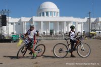
عاصمة المقاطعة
التراث الموسيقي

المصادر
- ^ "ARMM Regional Profile". Regional Board of Investments (RBOI) of the Autonomous Region in Muslim Mindanao (ARMM). Retrieved 22 June 2016. (There seems to be major discrepancies among authoritative sources: 972,904 ha (NSCB); 6,565 km² (Historical Dictionary of the Philippines); 5,176.1 km² (NAMRIA))
- ^ "Area information for Maguindanao". NSCB. Retrieved 28 January 2018.
- ^ "Provincial Summary - Number of Provinces, Cities, Municipalities and Barangays, by Region, as of December 31, 2013" (PDF). PSGC Interactive. National Statistical Coordination Board. Archived from the original (PDF) on 19 February 2014. Retrieved 30 May 2014.
- ^ خطأ استشهاد: وسم
<ref>غير صحيح؛ لا نص تم توفيره للمراجع المسماةmb - ^ خطأ استشهاد: وسم
<ref>غير صحيح؛ لا نص تم توفيره للمراجع المسماةmindanews - ^ أ ب
Census of Population (2015). Highlights of the Philippine Population 2015 Census of Population. PSA. Retrieved 20 يونيو 2016.
{{cite encyclopedia}}: Cite has empty unknown parameter:|chapterurl=(help)CS1 maint: numeric names: authors list (link) - ^ أ ب
Census of Population and Housing (2010). Population and Annual Growth Rates for The Philippines and Its Regions, Provinces, and Highly Urbanized Cities (PDF). NSO. Retrieved 29 يونيو 2016.
{{cite encyclopedia}}: Cite has empty unknown parameter:|chapterurl=(help)CS1 maint: numeric names: authors list (link) - ^ "Brief Profile". Provincial Government of Maguindanao. Archived from the original on 15 April 2015. Retrieved 15 April 2016.
Land Area; Maguindanao has a total land area of 597,052.79 hectares.
- ^ "PSGC Interactive; List of Provinces". Philippine Statistics Authority. Archived from the original on 11 January 2013. Retrieved 29 March 2016.
- ^
Census of Population and Housing (2010). Population and Annual Growth Rates for The Philippines and Its Regions, Provinces, and Highly Urbanized Cities (PDF). NSO. Retrieved 29 يونيو 2016.
{{cite encyclopedia}}: Cite has empty unknown parameter:|chapterurl=(help)CS1 maint: numeric names: authors list (link) - ^ Table 11. Household Population by Ethnicity and Sex: 2010 (Data excludes Cotabato City)
- ^ Philippine Statistics Authority (July 26, 2017). "Muslim Population in Mindanao (based on POPCEN 2015". Retrieved Aug 31, 2018.
وصلات خارجية
 Media related to ماگندناو at Wikimedia Commons
 ماگندناو travel guide from Wikivoyage
 Geographic data related to ماگندناو at OpenStreetMap
- COMELEC Resolution No. 8169
- COMELEC Plebiscite Results for 3 new Maguindanao municipalities
- Local Governance Performance Management System
- CS1 maint: numeric names: authors list
- Short description is different from Wikidata
- Pages using gadget WikiMiniAtlas
- Articles containing فيليپينو-language text
- Pages using Lang-xx templates
- Articles with hatnote templates targeting a nonexistent page
- Convert errors
- Articles with unsourced statements from July 2016
- قوائم إحداثيات
- Geographic coordinate lists
- Articles with Geo
- ماگندناو
- مقاطعات الفلپين
- دول وأقاليم تأسست في 1973
- تأسيسات 1973 في الفلپين
- صفحات مع الخرائط


