لايدار
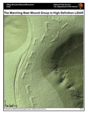
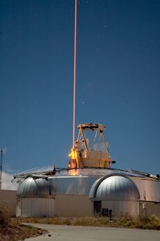
ليدار LIDAR مصطلح مشتق من الكلمات Light Detection and Ranging[1] أو "استخدام الليزر للتصوير والتعرف وتحديد المسافات".[2]
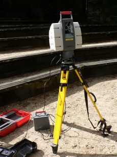
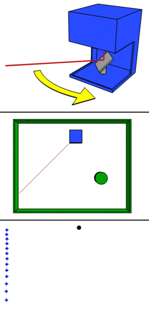
استخدام الليزر للاستشعار عن بعد. إذ يمكن باستخدام المرسِلات الليزرية والمستقبِلات الخاصة بها الحصول على معلومات عن بعد، حول الغلاف الجوي خصوصاً وحول الأرض عموماً. يتم بوساطة الليدار قياس تركيز المعلَّقات aerosols في الجو من غبار وسُحُب، كما يستخدم لقياس تركيز العديد من الغازات الملوِّثة كثنائي أكسيد النيتروجين، وثنائي أكسيد الكبريت والكلور والأوزون وبخار الماء وغاز النشادر وغيرها. كما يمكن أيضاً استخدامه لقياس الملوثات البيولوجية والعضوية المختلفة، وكذلك الغازات السامة الموجودة في الجو.[3] It is a method for determining ranges by targeting an object or a surface with a laser and measuring the time for the reflected light to return to the receiver. It is sometimes called 3-D laser scanning, a special combination of 3-D scanning and laser scanning.[4] LIDAR has terrestrial, airborne, and mobile applications.[5][6]
Lidar is commonly used to make high-resolution maps, with applications in surveying, geodesy, geomatics, archaeology, geography, geology, geomorphology, seismology, forestry, atmospheric physics,[7] laser guidance, airborne laser swath mapping (ALSM), and laser altimetry. It is used to make digital 3-D representations of areas on the Earth's surface and ocean bottom of the intertidal and near coastal zone by varying the wavelength of light. It has also been increasingly used in control and navigation for autonomous cars[8] and for the helicopter Ingenuity on its record-setting flights over the terrain of Mars.[9]
التاريخ وأصل الاسم
Under the direction of Malcolm Stitch, the Hughes Aircraft Company introduced the first lidar-like system in 1961,[10][11] shortly after the invention of the laser. Intended for satellite tracking, this system combined laser-focused imaging with the ability to calculate distances by measuring the time for a signal to return using appropriate sensors and data acquisition electronics. It was originally called "Colidar" an acronym for "coherent light detecting and ranging",[12] derived from the term "radar", itself an acronym for "radio detection and ranging". All laser rangefinders, laser altimeters and lidar units are derived from the early colidar systems. The first practical terrestrial application of a colidar system was the "Colidar Mark II", a large rifle-like laser rangefinder produced in 1963, which had a range of 7 miles (11 km) and an accuracy of 15 feet (4.6 m), to be used for military targeting.[13][11] The first mention of lidar as a stand-alone word in 1963 suggests that it originated as a portmanteau of "light" and "radar": "Eventually the laser may provide an extremely sensitive detector of particular wavelengths from distant objects. Meanwhile, it is being used to study the moon by 'lidar' (light radar) ..."[14][15] The name "photonic radar" is sometimes used to mean visible-spectrum range finding like lidar.[16][17]
Lidar's first applications were in meteorology, for which the National Center for Atmospheric Research used it to measure clouds and pollution.[18] The general public became aware of the accuracy and usefulness of lidar systems in 1971 during the Apollo 15 mission, when astronauts used a laser altimeter to map the surface of the Moon. Although the English language no longer treats "radar" as an acronym, (i.e., uncapitalized), the word "lidar" was capitalized as "LIDAR" or "LiDAR" in some publications beginning in the 1980s. No consensus exists on capitalization. Various publications refer to lidar as "LIDAR", "LiDAR", "LIDaR", or "Lidar". The USGS uses both "LIDAR" and "lidar", sometimes in the same document;[19] the New York Times predominantly uses "lidar" for staff-written articles,[20] although contributing news feeds such as Reuters may use Lidar.[21]
الوصف العام
Lidar uses ultraviolet, visible, or near infrared light to image objects. It can target a wide range of materials, including non-metallic objects, rocks, rain, chemical compounds, aerosols, clouds and even single molecules.[7] A narrow laser beam can map physical features with very high resolutions; for example, an aircraft can map terrain at 30-centimetre (12 in) resolution or better.[22]
The essential concept of lidar was originated by E. H. Synge in 1930, who envisaged the use of powerful searchlights to probe the atmosphere.[23][24] Indeed, lidar has since been used extensively for atmospheric research and meteorology. Lidar instruments fitted to aircraft and satellites carry out surveying and mapping – a recent example being the U.S. Geological Survey Experimental Advanced Airborne Research Lidar.[25] NASA has identified lidar as a key technology for enabling autonomous precision safe landing of future robotic and crewed lunar-landing vehicles.[26]
Wavelengths vary to suit the target: from about 10 micrometers (infrared) to approximately 250 nanometers (ultraviolet). Typically, light is reflected via backscattering, as opposed to pure reflection one might find with a mirror. Different types of scattering are used for different lidar applications: most commonly Rayleigh scattering, Mie scattering, Raman scattering, and fluorescence.[7] Suitable combinations of wavelengths can allow remote mapping of atmospheric contents by identifying wavelength-dependent changes in the intensity of the returned signal.[27] The name "photonic radar" is sometimes used to mean visible-spectrum range finding like lidar,[16][17] although photonic radar more strictly refers to radio-frequency range finding using photonics components.
التكنولوجيا
الصيغة الرياضية
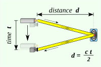
A lidar determines the distance of an object or a surface with the formula:[28]
where c is the speed of light, d is the distance between the detector and the object or surface being detected, and t is the time spent for the laser light to travel to the object or surface being detected, then travel back to the detector.
التصميم
The two kinds of lidar detection schemes are "incoherent" or direct energy detection (which principally measures amplitude changes of the reflected light) and coherent detection (best for measuring Doppler shifts, or changes in the phase of the reflected light). Coherent systems generally use optical heterodyne detection.[29] This is more sensitive than direct detection and allows them to operate at much lower power, but requires more complex transceivers.
Both types employ pulse models: either micropulse or high energy. Micropulse systems utilize intermittent bursts of energy. They developed as a result of ever-increasing computer power, combined with advances in laser technology. They use considerably less energy in the laser, typically on the order of one microjoule, and are often "eye-safe", meaning they can be used without safety precautions. High-power systems are common in atmospheric research, where they are widely used for measuring atmospheric parameters: the height, layering and densities of clouds, cloud particle properties (extinction coefficient, backscatter coefficient, depolarization), temperature, pressure, wind, humidity, and trace gas concentration (ozone, methane, nitrous oxide, etc.).[7]
المكونات
Lidar systems consist of several major components.
الليزر
600–1000 nm lasers are most common for non-scientific applications. The maximum power of the laser is limited, or an automatic shut-off system which turns the laser off at specific altitudes is used in order to make it eye-safe for the people on the ground.
One common alternative, 1550 nm lasers, are eye-safe at relatively high power levels since this wavelength is not strongly absorbed by the eye, but the detector technology is less advanced and so on these wavelengths are generally used at longer ranges with lower accuracies. They are also used for military applications because 1550 nm is not visible in night vision goggles, unlike the shorter 1000 nm infrared laser.
Airborne topographic mapping lidars generally use 1064 nm diode-pumped YAG lasers, while bathymetric (underwater depth research) systems generally use 532 nm frequency-doubled diode pumped YAG lasers because 532 nm penetrates water with much less attenuation than 1064 nm. Laser settings include the laser repetition rate (which controls the data collection speed). Pulse length is generally an attribute of the laser cavity length, the number of passes required through the gain material (YAG, YLF, etc.), and Q-switch (pulsing) speed. Better target resolution is achieved with shorter pulses, provided the lidar receiver detectors and electronics have sufficient bandwidth.[7]
التطبيقات
الزراعة
علم الآثار
علم الأحياء والبقاء
الجيولوجيا وعلوم التربة
الأرصاد وحماية البيئة
تطبيق القانون
العسكرية
الفيزياء والفلك
الروبوت
الرحلة الفضائية
الاستقصاء
النقل
Wind farm optimization
Solar Photovoltaic Deployment Optimization
استخدامات أخرى
التكنولوجية البديلة
انظر أيضاً
- Atomic line filter
- Ceilometer
- Clear-air turbulence
- CLidar
- Geodimeter
- Geological structure measurement by LiDAR
- مقياس المدى الليزري
- LAS file format
- libLAS
- Lidar detector
- List of laser articles
- National lidar dataset (all countries)
- National Lidar Dataset (United States)
- Optech
- Optical heterodyne detection
- Optical time-domain reflectometer
- Photogrammetry
- Range imaging
- Satellite laser ranging
- Seafloor mapping#LiDAR
- SODAR
- Time-domain reflectometry
- TopoFlight
المصادر
- ^ National Oceanic and Atmospheric Administration (26 February 2021). "What is LIDAR". oceanservice.noaa.gov (in الإنجليزية الأمريكية). US Department of Commerce. Retrieved 15 March 2021.
- ^ Travis S. Taylor (2019). Introduction to Laser Science and Engineering. CRC Press.
- ^ "الليدار". الموسوعة العربية.
- ^ Jie Shan and Charles K. Toth (2018). Topographic Laser Ranging and Scanning: Principles and Processing (2nd ed.). CRC Press.
- ^ "Adoption of gallium-based lidar sensors gathers pace". www.argusmedia.com (in الإنجليزية الأمريكية). 2021-06-29. Retrieved 2021-07-14.
- ^ "Ecologists compare accuracy of Lidar technologies for monitoring forest vegetation: Findings suggest mobile platforms have great potential for monitoring a variety of forest attributes". ScienceDaily (in الإنجليزية). Retrieved 2021-07-14.
- ^ أ ب ت ث ج Cracknell, Arthur P.; Hayes, Ladson (2007) [1991]. Introduction to Remote Sensing (2 ed.). London: Taylor and Francis. ISBN 978-0-8493-9255-9. OCLC 70765252.
- ^ Lim, Hazel Si Min; Taeihagh, Araz (2019). "Algorithmic Decision-Making in AVs: Understanding Ethical and Technical Concerns for Smart Cities". Sustainability (in الإنجليزية). 11 (20): 5791. arXiv:1910.13122. doi:10.3390/su11205791.
- ^ "How NASA Designed a Helicopter That Could Fly Autonomously on Mars". IEEE Spectrum. 17 February 2021. Archived from the original on 19 February 2021. Retrieved 19 February 2021.
- ^ "New Radar System". Odessa American. 28 Feb 1961.
- ^ أ ب Macomber, Frank (June 3, 1963). "Space Experts Seek Harness for Powerful LASER Light". Bakersfield Californian. No. p. 5. Copley News Service. Retrieved 11 July 2019.
- ^ Stitch, M. L.; Woodburry, E. J.; Morse, J H. (21 April 1961). "Optical ranging system uses laser transmitter". Electronics. 34: 51–53.
- ^ "Laser Measures Distance". Lincoln Journal Star. No. p. 6. 29 March 1963.
- ^ James Ring, "The Laser in Astronomy", pp. 672–673, New Scientist, June 20, 1963.
- ^ Oxford English Dictionary. 2013. p. Entry for "lidar".
- ^ أ ب "Photonic Radar". Technion – Israel Institute of Technology (in الإنجليزية الأمريكية). 27 May 2016. Retrieved 2018-08-12.
- ^ أ ب "Radio Optic Phased Array Radar – a comprehensive study". Full Afterburner (in الإنجليزية). Retrieved 2018-08-12.
- ^ Goyer, G. G.; R. Watson (September 1963). "The Laser and its Application to Meteorology". Bulletin of the American Meteorological Society. 44 (9): 564–575 [568]. Bibcode:1963BAMS...44..564G. doi:10.1175/1520-0477-44.9.564.
- ^ "CLICK". Lidar.cr.usgs.gov. 2015-09-16. Archived from the original on 2016-02-19. Retrieved 2016-02-22.
- ^ "NYTimes.com search". The New York Times. Retrieved 2017-04-07.
- ^ "Waymo Self-Driving Unit Sought Arbitration Over Engineer Now at Uber". The New York Times. 2017-03-29. Retrieved 2017-04-07.
- ^ Carter, Jamie; Keil Schmid; Kirk Waters; Lindy Betzhold; Brian Hadley; Rebecca Mataosky; Jennifer Halleran (2012). "Lidar 101: An Introduction to Lidar Technology, Data, and Applications" (PDF). NOAA Coastal Services Center. p. 14. Archived (PDF) from the original on 2022-10-09. Retrieved 2017-02-11.
- ^ Philosophical Magazine and Journal of Science, 1930, series 7, volume 9, issue 60, pp. 1014–1020.
- ^ Donegan, J. F.; The Life and Works of Edward Hutchinson Synge, pp. 31, 67, (co-edited with D. Weaire and P. Florides), Pöllauberg, Austria : Living Edition, ISBN 3901585176.
- ^ "Experimental Advanced Advanced Research Lidar", USGS.gov. Retrieved 8 August 2007.
- ^ Amzajerdian, Farzin; Pierrottet, Diego F.; Petway, Larry B.; Hines, Glenn D.; Roback, Vincent E. (2011-05-24). "Lidar Systems for Precision Navigation and Safe Landing on Planetary Bodies". International Symposium on Photoelectronic Detection and Imaging 2011: Laser Sensing and Imaging; and Biological and Medical Applications of Photonics Sensing and Imaging. 8192: 819202. Bibcode:2011SPIE.8192E..02A. doi:10.1117/12.904062. hdl:2060/20110012163. S2CID 28483836. Retrieved May 24, 2011.
- ^ P. Dakin, John; Brown, Robert (2017). Handbook of Optoelectronics: Concepts, Devices, and Techniques (Volume One). CRC Press. p. 678. ISBN 978-1-4822-4179-2.
- ^ Rohrbach, Felix (February 4, 2015). "An Introduction to LiDAR". felix.rohrba.ch. Retrieved March 28, 2022.
- ^ Rashid A. Ganeev (2013). Laser – Surface Interactions. Springer Science & Business Media. p. 32. ISBN 9789400773417.
WANG, J., ZHANG, J., RONCAT, A., KUENZER, C., WAGNER, W., 2009: Regularizing method for the determination of the backscatter cross section in lidar data, In: J. Opt. Soc. Am. A Vol. 26, No. 5/May 2009/, 1084-7529/09/051071-9, pp. 1071-1079
وصلات خارجية
- The USGS Center for LIDAR Information Coordination and Knowledge (CLICK) - A website intended to "facilitate data access, user coordination and education of lidar remote sensing for scientific needs."
- How Lidar Works
- LiDAR Research Group (LRG), University of Heidelberg
