كي وست
City of Key West, Florida | |
|---|---|
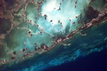
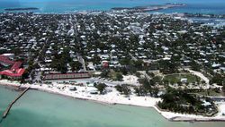 Aerial photo of Key West, looking north, April 2001 | |
| الكنية: "The Conch Republic", "Southernmost City in the Continental United States" | |
| الشعار: One Human Family | |
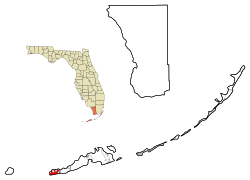 Location in Monroe County and the state of Florida | |
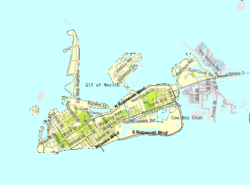 U.S. Census Bureau map showing city limits | |
| الإحداثيات: 24°33′33″N 81°47′2.51″W / 24.55917°N 81.7840306°W | |
| Country | United States |
| State | Florida |
| County | Monroe |
| الحكومة | |
| • النوع | Council–manager |
| • Mayor | Craig C. Cates |
| المساحة | |
| • الإجمالي | 7٫24 ميل² (18٫76 كم²) |
| • البر | 5٫60 ميل² (14٫50 كم²) |
| • الماء | 1٫64 ميل² (4٫26 كم²) |
| المنسوب | 18 ft (5 m) |
| التعداد | |
| • الإجمالي | 24٬649 |
| • Estimate (2016)[3] | 26٬990 |
| • الكثافة | 4٬819٫64/sq mi (1٬860٫87/km2) |
| منطقة التوقيت | UTC-5 (Eastern (EST)) |
| • الصيف (التوقيت الصيفي) | UTC-4 (EDT) |
| ZIP codes | 33040, 33041, 33045 |
| مفتاح الهاتف | 305 and 786 (305 Exchanges: 292,293,294,295,296,809) |
| FIPS code | 12-36550[2] |
| GNIS feature ID | 0294048[4] |
| الموقع الإلكتروني | Official website |
Key West (إسپانية: Cayo Hueso) is an island and city in the Straits of Florida on the North American continent. The city lies at the southernmost end of U.S. Route 1, the longest north-south road in the United States. Key West is the southernmost city in the contiguous United States and the westernmost island connected by highway in the Florida Keys. The island is about 4 miles (6.4 km) long and 1 mile (1.6 km) wide, with a total land mass of 4.2 square miles (11 km2).[5] Duval Street, its main street, is 1.1 miles (1.8 km) in length in its 14-block-long crossing from the Gulf of Mexico to the Straits of Florida and the Atlantic Ocean. Key West is about 95 miles (153 km) north of Cuba at their closest points.[6][7]
The city is the county seat of Monroe County.[8] The city boundaries include the island of Key West and all or part of several nearby islands: Sigsbee Park, Fleming Key, Sunset Key, and the northern part of Stock Island. The total land area of the city is 5.6 square miles (14.5 km2).[1] Key West is the southern terminus of U.S. Route 1, State Road A1A, the East Coast Greenway and, before 1935, the Florida East Coast Railway.
Key West is 129 miles (208 km) southwest of Miami by air,[9] about 160 miles (260 km) by car, and 106 miles (171 km) north-northeast of Havana.[10] Key West is a port of call for many passenger cruise ships.[11] The Key West International Airport provides airline service. Naval Air Station Key West is an important year round training site for naval aviation due to the tropical weather, which is also the reason Key West was chosen as the Winter White House of President Harry S. Truman. The central business district is located along Duval Street and includes much of the northwestern corner of the island. The official city motto is "One Human Family."
. . . . . . . . . . . . . . . . . . . . . . . . . . . . . . . . . . . . . . . . . . . . . . . . . . . . . . . . . . . . . . . . . . . . . . . . . . . . . . . . . . . . . . . . . . . . . . . . . . . . . . . . . . . . . . . . . . . . . . . . . . . . . . . . . . . . . . . . . . . . . . . . . . . . . . . . . . . . . . . . . . . . . . . .
History
Early history
The Keys were originally inhabited by Calusa and Tequesta Native Americans, and were later charted by Juan Ponce de León in 1513. De León named the islands Los Martires ("The Martyrs"), as they looked like suffering men from a distance.[12] "Key" is derived from the Spanish word cayo, meaning small island. For many years, Key West was the largest town in Florida, and it grew prosperous on wrecking revenues. The isolated outpost was well located for trade with Cuba and the Bahamas, and was on the main trade route from New Orleans. Improved navigation led to fewer shipwrecks, and Key West went into a decline in the late nineteenth century.
Overseas Railway
The Keys were long accessible only by water. This changed with the completion of Henry Flagler's Overseas Railway in the early 1910s. Flagler, a major developer of Florida's Atlantic coast, extended his Florida East Coast Railway down to Key West with an ambitious series of oversea railroad trestles. Three hurricanes disrupted the project in 1906, 1909, and 1910.
Labor Day Hurricane of 1935
The worst hurricane to strike the U.S. made landfall near Islamorada in the Upper Keys on Labor Day, Monday, September 2. Winds were estimated to have gusted to 200 mph (320 km/h), raising a storm surge more than 17.5 feet (5.3 m) above sea level that washed over the islands. More than 400 people were killed, though some estimates place the number of deaths at more than 600.
The Labor Day Hurricane was one of only three hurricanes to make landfall at Category 5 strength on the U.S. coast since reliable weather records began (about 1850). The other storms were Hurricane Camille (1969) and Hurricane Andrew (1992).
In 1935, new bridges were under construction to connect a highway through the entire Keys. Hundreds of World War I veterans working on the roadway as part of a government relief program were housed in non-reinforced buildings in three construction camps in the Upper Keys. When the evacuation train failed to reach the camps before the storm, more than 200 veterans perished. Their deaths caused anger and charges of mismanagement that led to a Congressional investigation.
The storm also ended the 23-year run of the Overseas Railway; the damaged tracks were never rebuilt, and the Overseas Highway (U.S. Highway 1) replaced the railroad as the main transportation route from Miami to Key West.[13]
Seven Mile Bridge
One of the longest bridges when it was built, the Seven Mile Bridge connects Knight's Key (part of the city of Marathon in the Middle Keys) to Little Duck Key in the Lower Keys. The piling-supported concrete bridge is 35,862 ft (10,931 m) or 6.79 miles (10.93 km) long. The current bridge bypasses Pigeon Key, a small island that housed workers building Henry Flagler's Florida East Coast Railway in the 1900s, that the original Seven Mile Bridge crossed. A 2.2-mile (3.5 km) section of the old bridge remains for access to the island, although it was closed to vehicular traffic on March 4, 2008. The aging structure has been deemed unsafe by the Florida Department of Transportation. Costly repairs, estimated to be as much as $34 million, were expected to begin in July 2008. Monroe County was unable to secure a $17 million loan through the state infrastructure bank, delaying work for at least a year. On June 14, 2008, the old bridge section leading to Pigeon Key was closed to fishing as well. While still open to pedestrians—walking, biking and jogging—if the bridge were closed altogether, only a ferry subsidized by FDOT and managed by the county would transport visitors to the island.
Overseas Highway
After the destruction of the Keys railway by the Labor Day Hurricane of 1935, the railroad bridges, including the Seven Mile Bridge, were converted to automobile roadways. This roadway, U.S. Highway 1, became the Overseas Highway that runs from Key Largo south to Key West. Today this unique highway allows travel through the tropical islands of the Florida Keys and view exotic plants and animals found nowhere else on the US mainland and the largest coral reef chain in the United States.
Cuban exiles
Following the Cuban Revolution, many Cubans fled to South Florida. Key West traditionally had strong links with its neighbor ninety miles south by water, and large numbers of Cubans settled there. The Keys still attract Cubans leaving their home country, and stories of "rafters" coming ashore are not uncommon.[بحاجة لمصدر]
Conch Republic
In 1982, the United States Border Patrol established a roadblock and inspection points on US Highway 1, stopping all northbound traffic returning to the mainland at Florida City, to search vehicles for illegal drugs and undocumented peoples. The Key West City Council repeatedly complained about the roadblocks, which were a major inconvenience for travellers, and hurt the Keys' important tourism industry.
After various unsuccessful complaints and attempts to get a legal injunction against the blockade failed in federal court in Miami, on April 23, 1982, Key West mayor Dennis Wardlow and the city council declared the independence of the city of Key West, calling it the "Conch Republic". After one minute of secession, he (as "Prime Minister") surrendered to an officer of the Key West Naval Air Station (NAS), and requested one billion ($1,000,000,000) dollars in "foreign aid".[14]
The stunt succeeded in generating great publicity for the Keys' plight, and the inspection station roadblock was removed. The idea of the Conch Republic has provided a new source of revenue for the Keys by way of tourist keepsake sales, and the Conch Republic has participated in later protests.
Geography
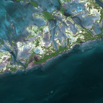
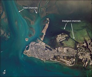 Key West from space, October 2002 | |
 | |
| الجغرافيا | |
|---|---|
| الإحداثيات | 24°33′33″N 81°47′03″W / 24.559166°N 81.784031°W |
| الأرخبيل | Florida Keys |
| الجزر الرئيسية | Key West, Key Largo, Islamorada, Marathon |
| المساحة | 4.2 sq mi (11 km2) |
| الطول | 4 mi (6 km) |
| العرض | 1 mi (2 km) |
| أعلى منسوب | 18 ft (5٫5 m) |
| أعلى نقطة | Solares Hill, 18 feet (5.5 m) above sea level |
The island is about 4 miles (6.4 km) long and 1 mile (1.6 km) wide, with a total land area of 4.2 square miles (11 km2).[5]
The city boundaries include the island of Key West and several nearby islands, as well as the section of Stock Island north of U.S. Route 1, on the adjacent key to the east. The total land area of the city is 5.6 square miles (15 km2).[1] Sigsbee Park—originally known as Dredgers Key—and Fleming Key, both located to the north, and Sunset Key located to the west are all included in the city boundaries. Both Fleming Key and Sigsbee Park are part of Naval Air Station Key West and are inaccessible to the general public.
Key West is located at 24°33′33″N 81°47′03″W / 24.55917°N 81.78417°W.[15] The maximum elevation above sea level is about 18 feet (5.5 m), a 1-acre (4,047 m2) area known as Solares Hill.[16][17]
In the late 1950s, many of the large salt ponds on the eastern side were filled in. The new section on the eastern side is called New Town which contains shopping centers, retail malls, residential areas, schools, ball parks, and Key West International Airport.
Key West and most of the rest of the Keys are on the dividing line between the Atlantic Ocean and the Gulf of Mexico. The two bodies have different currents, with the calmer and warmer Gulf of Mexico being characterized by great clumps of seagrass. The area where the two bodies merge between Key West and Cuba is called the Straits of Florida. The warmest ocean waters anywhere on the United States mainland are found in the Florida Keys in winter, with sea surface temperatures averaging in the 75 to 77 °F range in December through February.
Duval Street, its main street, is 1.1 miles (1.8 km) in length in its 14-block-long crossing from the Gulf of Mexico to the Straits of Florida and the Atlantic Ocean.
Key West is closer to Havana (106 miles, or 170 km) than it is to Miami (127 miles or 207 km, farther by boat). Key West is the usual endpoint for marathon swims from Cuba, including Diana Nyad's 2013 record-setting swim as the first completed without a shark cage or fins[18][19] and Susie Maroney's 1997 swim from within a shark cage.[20]
. . . . . . . . . . . . . . . . . . . . . . . . . . . . . . . . . . . . . . . . . . . . . . . . . . . . . . . . . . . . . . . . . . . . . . . . . . . . . . . . . . . . . . . . . . . . . . . . . . . . . . . . . . . . . . . . . . . . . . . . . . . . . . . . . . . . . . . . . . . . . . . . . . . . . . . . . . . . . . . . . . . . . . . .
Notable places
Old Town
The earliest Key West neighborhoods, on the western part of the island, are broadly known as Old Town. The Key West Historic District includes the major tourist destinations of the island, including Mallory Square, Duval Street, the Truman Annex and Fort Zachary Taylor. Old Town is where the classic bungalows and guest mansions are found. Bahama Village, southwest of Whitehead Street, features houses, churches, and sites related to its Afro-Bahamian history. The Meadows, lying northeast of the White Street Gallery District, is exclusively residential.
Generally, the structures date from 1886 to 1912. The basic features that distinguish the local architecture include wood-frame construction of one- to two-and-a-half-story structures set on foundation piers about three feet (one meter) above the ground. Exterior characteristics of the buildings are peaked metal roofs, horizontal wood siding, gingerbread trim, pastel shades of paint, side-hinged louvered shutters, covered porches (or balconies, galleries, or verandas) along the fronts of the structures, and wood lattice screens covering the area elevated by the piers.
Some antebellum structures survive, including the Oldest (or Cussans-Watlington) House (1829–1836)[21] and the John Huling Geiger House (1846–1849), now preserved as the Audubon House and Tropical Gardens.[22] Fortifications such as Fort Zachary Taylor,[23] the East Martello Tower,[24] and the West Martello Tower,[25] helped ensure that Key West would remain in Union control throughout the Civil War. Another landmark built by the federal government is the Key West Lighthouse, now a museum.[26]
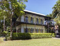
Two of the most notable buildings in Old Town, occupied by prominent twentieth-century residents, are the Ernest Hemingway House, where the writer lived from 1931 to 1939, and the Harry S. Truman Little White House, where the president spent 175 days of his time in office.[27] Additionally, the residences of some historical Key West families are recognized on the National Register of Historic Places as important landmarks of history and culture, including the Porter House on Caroline Street[28] and the Gato House on Virginia Street.[29]
Several historical residences of the Curry family remain extant, including the Benjamin Curry House, built by the brother of Florida's first millionaire, William Curry,[30] as well as the Southernmost Mansion and the Fogarty Mansion, built by the children of William Curry—his daughter Florida and son Charles, respectively.[31]
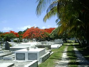
In addition to architecture, Old Town includes the Key West Cemetery, founded in 1847,[32] containing above-ground tombs, notable epitaphs, and a plot where some of the dead from the 1898 explosion of the يوإسإس Maine are buried.[33][34]
Casa Marina
The Casa Marina area takes its name from the Casa Marina Hotel, opened in 1921,[35] the neighborhood's most conspicuous landmark. The Reynolds Street Pier, Higgs Beach,[36] the West Martello Tower, the White Street Pier, and Rest Beach line the waterfront.
Southernmost point in the U.S.
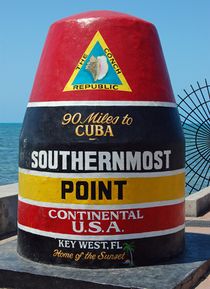
One of the most popular attractions on the island is a concrete replica of a buoy at the corner of South and Whitehead Streets that claims to be the southernmost point in the contiguous United States. The point was originally marked with a basic sign. The city of Key West erected the current monument in 1983.[37] The monument was repainted after damage by Hurricane Irma in 2017.[38]
The monument is labeled "Southernmost point continental U.S.A."; however, Whitehead Spit, on the Truman Annex property just west of the buoy, is the actual southernmost point of Key West. The spit has no marker since it is on U.S. Navy land which cannot be entered by civilian tourists. The private property directly to the east of the buoy, and the beach areas of Truman Annex and Fort Zachary Taylor Historic State Park, also lie farther south than the buoy. The southernmost location that the public can visit is the beach at Fort Zachary Taylor park. The actual southernmost point of the contiguous United States is Ballast Key, a privately owned island just south and west of Key West.
The claim "90 Miles to Cuba" on the monument is close to correct; Cuba at its closest point has been measured at 95 statute miles (153 km) from Key West.[6][7]
Notable residences
Winter White House
Several U.S. presidents have visited Key West with the first being Ulysses S. Grant in 1880, followed by Grover Cleveland in 1889, and William Howard Taft in 1912.[39] Taft was the first president to use the first officer's quarters that would later be known as the Little White House.[40] Franklin D. Roosevelt visited the Florida Keys many times, beginning in 1917.[39]
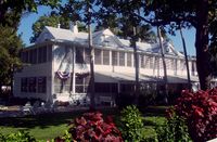
Harry S. Truman visited Key West for a total of 175 days on 11 visits during his presidency and visited five times after he left office. His first visit was in 1946.[41] The Little White House and Truman Annex take their names from his frequent and well-documented visits. The residence is also known as the Winter White House as Truman stayed there mostly in the winter months, and used it for official business such as the Truman Doctrine.[42]
Dwight D. Eisenhower stayed at the Little White House following a heart attack in 1955.[39] John F. Kennedy visited Key West in March 1961, and in November 1962, a month after the resolution of the Cuban Missile Crisis. Jimmy Carter visited the Little White House twice with his family after he had left office, in 1996 and 2007.[41]
Ernest Hemingway house
Legend has it that Ernest Hemingway wrote part of A Farewell to Arms while living above the showroom of a Key West Ford dealership at 314 Simonton Street[43] while awaiting delivery of a Ford Model A roadster purchased by the uncle of his wife Pauline in 1928.[44]
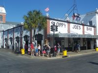
Hardware store owner Charles Thompson introduced him to deep-sea fishing. Among the group who went fishing was Joe Russell (also known as Sloppy Joe). Russell was reportedly the model for Freddy in To Have and Have Not.[بحاجة لمصدر] Portions of the original manuscript were found at Sloppy Joe's Bar after his death.[بحاجة لمصدر] The group had nicknames for each other, and Hemingway wound up with "Papa".
Pauline's rich uncle Gus Pfeiffer bought the 907 Whitehead Street house[45] in 1931 as a wedding present. The Hemingways installed a swimming pool for $20,000 in 1937–38 (equivalent to about $Format price error: cannot parse value "Error when using {{Inflation}}: |index=US-GDP (parameter 1) not a recognized index." in 2022). The unexpectedly high cost prompted Hemingway to put a penny in the wet cement of the patio, saying, "Here, take the last penny I've got!" The penny is at the north end of the pool.[46]
During his stay he wrote or worked on Death in the Afternoon, For Whom the Bell Tolls, The Snows of Kilimanjaro, and The Short Happy Life of Francis Macomber. He used Depression-era Key West as one of the locations in To Have and Have Not—his only novel with scenes that occur in the United States.
Pauline and Hemingway divorced in 1939; Hemingway only occasionally visited when returning from Havana until his suicide in 1961.
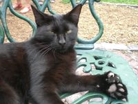
The six- or seven-toed polydactyl cats descended from Hemingway's original pet "Snowball" still live on the grounds and are cared for at the Hemingway House, despite complaints by the U.S. Department of Agriculture that they are not kept free from visitor contact. The Key West City Commission has exempted the house from a law prohibiting more than four domestic animals per household.
A polydactyl cat with seven toes at Hemingway's house
Tennessee Williams house
Tennessee Williams first became a regular visitor to Key West in 1941 and is said to have written the first draft of A Streetcar Named Desire while staying in 1947 at the La Concha Hotel. He bought a permanent house in 1949 and listed Key West as his primary residence until his death in 1983. In contrast to Hemingway's grand house in Old Town, the Williams home at 1431 Duncan Street[47] in the "unfashionable" New Town neighborhood is a very modest bungalow. The house is privately owned and not open to the public. The Academy Award–winning film version of his play The Rose Tattoo was shot on the island in 1956. The Tennessee Williams Theatre is located on the campus of Florida Keys Community College on Stock Island.[48]
Williams had a series of rented homes all over the United States, but the only home he owned was in Key West.
Even though Hemingway and Williams lived in Key West at the same time, they reportedly met only once—at Hemingway's home in Cuba, Finca Vigía.{{Citation needed}}
. . . . . . . . . . . . . . . . . . . . . . . . . . . . . . . . . . . . . . . . . . . . . . . . . . . . . . . . . . . . . . . . . . . . . . . . . . . . . . . . . . . . . . . . . . . . . . . . . . . . . . . . . . . . . . . . . . . . . . . . . . . . . . . . . . . . . . . . . . . . . . . . . . . . . . . . . . . . . . . . . . . . . . . .
Port of Key West
The first cruise ship was the Sunward in 1969, which docked at the Navy's pier in the Truman Annex or the privately owned Pier B. The Navy's pier is called the Navy Mole.
In 1984, the city opened a pier right on Mallory Square. The decision was met with considerable opposition from people who felt it would disrupt the tradition of watching the sunset at Mallory Square. Cruise ships now dock at all three piers.
Cruise Ship Statistics for 1994:[49]
- Number of visits: 368
- Passenger count: 398,370
- City revenues from docking charges: $852,887
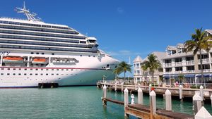
In present times,[when?] several cruise ships dock on a regular basis at Key West, including the Royal Caribbean ship Majesty of the Seas and the Carnival Fascination, both of which visit weekly. In the last several years, however, larger cruise ships have increasingly bypassed Key West due to the narrowness of the island's main ship channel. On October 1, 2013, 74% of resident voters opposed a referendum that would have allowed the City Commission to request a feasibility study from the Army Corps of Engineers for a $36 million project to dredge a wider channel.[50] Economic benefits from visiting cruise ship passengers are substantial but not attractive to all Key West citizens as the daily presence of thousands of tourists from cruise ships affects the character of the city, resulting in operation of facilities that cater to mass tourism rather than to a potentially more profitable and pleasant upscale clientele. There are also environmental issues as Key West is surrounded by coral habitat.[11] Concerns over environmental protection were considered a prominent factor in the failure of the 2013 referendum.[51]
اعتبارا من 2009[تحديث], there were 859,409 passengers annually.[52]
الهامش
- ^ أ ب ت "2016 U.S. Gazetteer Files". United States Census Bureau. Retrieved يوليو 7, 2017.
- ^ أ ب "American FactFinder". United States Census Bureau. Retrieved يناير 31, 2008.
- ^ "Population and Housing Unit Estimates". Retrieved يونيو 9, 2017.
- ^ "US Board on Geographic Names". United States Geological Survey. أكتوبر 25, 2007. Retrieved يناير 31, 2008.
- ^ أ ب "Key West City Information: Regional Setting". فبراير 4, 2006. Archived from the original on ديسمبر 24, 2013.
{{cite web}}: Unknown parameter|deadurl=ignored (|url-status=suggested) (help) - ^ أ ب "ACME Mapper". Mapper.acme.com. ACME Labs.
Zoom out, drag map until the center pointer is on the Cuban coast, zoom in and adjust position, then click the 'Markers' button at bottom right of map. Units can be changed via the 'Options' button.
- ^ أ ب "Latitude/Longitude Distance Calculator". Nhc.noaa.gov. National Hurricane Center.
Coordinates used for Key West (the Whitehead Spit): 24.54410 (N), 81.80486 (W), and for Cuba (a headland just west of Santa Cruz del Norte): 23.18375 (N), 82.0003 (W).
- ^ "Find a County". National Association of Counties. Archived from the original on مايو 31, 2011. Retrieved يونيو 7, 2011.
{{cite web}}: Unknown parameter|deadurl=ignored (|url-status=suggested) (help) - ^ "How Far is It? Distance Server: As the Crow Flies".
- ^ "How Far is It? Distance Server: As the Crow Flies".
- ^ أ ب Lizette Alvarez (ديسمبر 24, 2012). "Key West Looks at Identity as It Plots Tourism Future". The New York Times. Retrieved ديسمبر 25, 2012.
- ^ Journal of Antonio de Herrera quoted in Goodwin-Nguyen, S (2008) Key West: A Comprehensive Guide to Florida's Southernmost City, Channel Lake, p. 19.
- ^ "about". overseasrailroad.railfan.net.
- ^ The Conch Republic Archived 2012-11-02 at the Wayback Machine
- ^ "US Gazetteer files: 2010, 2000, and 1990". United States Census Bureau. فبراير 12, 2011. Retrieved أبريل 23, 2011.
- ^ "Solares Hill". Peakbagger.com. Retrieved يوليو 16, 2018.
- ^ "National Weather Service Forecast Office - WFO Key West, Florida". سبتمبر 16, 2006. Archived from the original on سبتمبر 16, 2006. Retrieved يوليو 16, 2018.
{{cite web}}: Unknown parameter|dead-url=ignored (|url-status=suggested) (help) - ^ "First person to swim from Cuba to Florida without a shark cage or fins". Guinnessworldrecords.com. Guinness World Records. Retrieved March 23, 2018.
- ^ Press, Associated (سبتمبر 11, 2013). "Diana Nyad defends Cuba-to-Florida swim as skeptics question use of gear". The Guardian (in الإنجليزية البريطانية). ISSN 0261-3077. Retrieved يناير 28, 2016.
- ^ CNN Staff (September 1, 2013). "Diana Nyad's Cuba to Florida swim breaks one record". Cnn.com. Cable News Network. Retrieved March 23, 2018.
- ^ "Old Island Restoration Foundation's Key West Oldest House Museum and Garden". oirf.org. Retrieved يناير 5, 2016.
- ^ "About the Audubon House – Audubon House & Tropical Gardens". Audubon House & Tropical Gardens (in الإنجليزية الأمريكية). Retrieved يناير 5, 2016.
- ^ "Fort Zachary Taylor". Fortzacharytaylor.com. Archived from the original on ديسمبر 12, 2015. Retrieved يناير 5, 2016.
{{cite web}}: Unknown parameter|deadurl=ignored (|url-status=suggested) (help) - ^ "Key West Art & Historical Society | Fort East Martello". Kwahs.org. Retrieved يناير 5, 2016.
- ^ "Tower History". Keywestgardenclub.com. Retrieved يناير 5, 2016.
- ^ "Key West Art & Historical Society | Lighthouse & Keeper's Quarters". Kwahs.org. Retrieved يناير 5, 2016.
- ^ "Key West Museum History | Truman Little White House". Trumanlittlewhitehouse.com. Retrieved يناير 5, 2016.
- ^ "National Register of Historic Places Inventory Nomination Form for Dr. Joseph Y. Porter House". Npgallery.nps.gov. National Park Service. June 4, 1973. Retrieved June 22, 2018.
- ^ "National Register of Historic Places Inventory Nomination Form for Eduardo H. Gato House". Npgallery.nps.gov. National Park Service. April 11, 1973. Retrieved June 22, 2018.
- ^ "Marker Details - Key West Historic Markers Project". Keywesthistoricmarkertour.org. Retrieved يوليو 4, 2018.
- ^ "Marker Details - Key West Historic Markers Project". Keywesthistoricmarkertour.org. Retrieved يوليو 4, 2018.
- ^ "Key West Cemetery". Keywesttravelguide.com. Key West Travel Guide, LLC. Retrieved March 23, 2018.
- ^ "Key West Cemetery Map & Self-Guided Tour". Keywesttravelguide.com. Key West Travel Guide, LLC. Retrieved March 23, 2018.
- ^ US Army Quartermaster (1913). US Army Quartermaster Report of 1912. US War Department. p. 511. Retrieved مارس 23, 2018.
- ^ "Key West Resorts – Waldorf Astoria Casa Marina Hotel – FL". Casamarinaresort.com. Retrieved يناير 5, 2016.
- ^ "Monroe County, FL – Official Website – Higgs Beach". Monroecounty-fl.gov. Retrieved يناير 5, 2016.
- ^ Key West History Archived ديسمبر 2, 2008 at the Wayback Machine
- ^ O'Brien, Bridget. "Southernmost Point Buoy In Key West Shines Again" (in الإنجليزية). Retrieved ديسمبر 2, 2018.
- ^ أ ب ت Klingener, Nancy (أبريل 18, 2018). "Power Magnet: Key West's Long History Of Presidential Visits" (in الإنجليزية). Retrieved ديسمبر 2, 2018.
- ^ "Truman Little White House | Key West Museum History". www.trumanlittlewhitehouse.com. Retrieved ديسمبر 2, 2018.
- ^ أ ب "Truman Little White House | Truman Key West visits". trumanlittlewhitehouse.com. Truman Little White House. Retrieved December 2, 2018.
- ^ "Truman Little White House | Media center". trumanlittlewhitehouse.com. Truman Little White House. Retrieved December 2, 2018.
- ^ Google (يناير 27, 2015). "314 Simonton Street, Key West, Fl" (Map). Google Maps. Google. Retrieved يناير 27, 2015.
- ^ McIver, Stuart B. (2002). Hemingway's Key West. Pineapple Press Inc. p. 7. ISBN 978-1-56164-241-0.
- ^ Google (يناير 27, 2015). "907 Whitehead Street, Key West, Fl" (Map). Google Maps. Google. Retrieved يناير 27, 2015.
- ^ "Hemingway – The Legend". hemingwayhome.com. Hemingway Home. Retrieved December 2, 2018.
- ^ Google (يناير 27, 2015). "1431 Duncan Street, Key West, Fl" (Map). Google Maps. Google. Retrieved يناير 27, 2015.
- ^ Google (يناير 27, 2015). "5901 College Road, Key West, Fl" (Map). Google Maps. Google. Retrieved يناير 27, 2015.
- ^ A Chronological History of Key West: A Tropical Island City, Stephen Nichols
- ^ Filosa, Gwen (أكتوبر 6, 2013). "Anti-study side: 'No means no'". The Key West Citizen. Archived from the original on سبتمبر 14, 2015. Retrieved سبتمبر 16, 2015.
{{cite news}}: Unknown parameter|deadurl=ignored (|url-status=suggested) (help) - ^ Filosa, Gwen (فبراير 2, 2014). "New process for city to alter channel". The Key West Citizen. Archived from the original on سبتمبر 14, 2015. Retrieved سبتمبر 16, 2015.
{{cite news}}: Unknown parameter|deadurl=ignored (|url-status=suggested) (help) - ^ City of Key West Port Operations Office
وصلات خارجية
- Official website
- Monroe County School District—Key West Public Schools
- Key West Art Galleries
- Key West Citizen
- Nautical Chart of Key West
- Map of Webcams in Key West
- Films produced in the Florida Keys and Key West
قالب:Monroe County, Florida قالب:Florida Keys
خطأ لوا في وحدة:Authority_control على السطر 278: attempt to call field '_showMessage' (a nil value).
- Pages using gadget WikiMiniAtlas
- CS1 errors: unsupported parameter
- CS1 الإنجليزية البريطانية-language sources (en-gb)
- CS1 الإنجليزية الأمريكية-language sources (en-us)
- Articles with hatnote templates targeting a nonexistent page
- Missing redirects
- Use mdy dates from March 2017
- Short description is different from Wikidata
- Pages using infobox settlement with possible nickname list
- Coordinates on Wikidata
- صفحات تستخدم جدول مستوطنة بقائمة محتملة لمفاتيح الهاتف
- Official website different in Wikidata and Wikipedia
- Articles containing إسپانية-language text
- Pages using Lang-xx templates
- مقالات ذات عبارات بحاجة لمصادر
- Infobox mapframe without OSM relation ID on Wikidata
- Articles with unsourced statements from December 2018
- Pages with errors in inflation template
- Vague or ambiguous time from March 2018
- مقالات فيها عبارات متقادمة منذ 2009
- جميع المقالات التي فيها عبارات متقادمة
- Beaches of Florida
- Beaches of Monroe County, Florida
- Cities in Florida
- Cities in Monroe County, Florida
- County seats in Florida
- Islands of Monroe County, Florida
- Islands of Florida
- Islands of the Florida Keys
- Key West, Florida
- Micropolitan areas of Florida
- Populated coastal places in Florida on the Gulf of Mexico
- Port cities and towns of the Florida Gulf coast
- Seaside resorts in Florida
- صفحات مع الخرائط

