قالب:Italy Labelled Map Scalable
Template:Italy Labelled Map Scalable
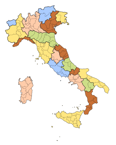
- خريطة تبين المستوى الأول من الكيانات المكونة للجمهورية الإيطالية.
- Location labels in the map are clickable wiki-links, leading to the respective article(s) and 'hoverable' with pop-ups etc.
Parameters
| Parameter | Description |
|---|---|
| float | alignment for template display: |float=left or |float=right (default is right)
|
| image-width | width for displayed template in px (default is 455) |
| border-width | border width in px (default is 0, no border) |
| border-color | border colour specified as CSS colour (default is silver) |
- Note: At sizes below about 300px, type may start to "collide" due to the label size supplied by
{{Image label small}}. - If such small sizes are really required, it would be best to create a new version with better font-size specifications, or use a different method like Image map, and include the type in the svg image so it scales properly.
Example usage
{{Italy Labelled Map Scalable|float=left|image-width=350|border-width=1}}
{{Italy Labelled Map Scalable|float=left|image-width=350|border-width=1|border-color=#770453}}

- Example using Image frame
{{Image frame
|content={{Italy Labelled Map Scalable
         |float=right
         |border-width=1
         |image-width=375
         }}
|caption=The first-level [[Administrative division|constituent entities]] of the Italian Republic
|innerstyle=border:none;
}}

General Image label documentation
General Image label documentation
| ||||
|---|---|---|---|---|
This template is a self-reference and thus is part of the Wikipedia project rather than the encyclopaedic content. This template will automatically categorise the current template into: Category:Labelled map templates.
Consider this example, adapted from Template:Australia Labelled Map: {{Image label begin|image=Australia location map recolored.png
|alt=Australia map. Western Australia in the west third with capital Perth, Northern Territory in the north center with capital Darwin, Queensland in the northeast with capital Brisbane, South Australia in the south with capital Adelaide, New South Wales in the northern southeast with capital Sydney, and Victoria in the far southeast with capital Melbourne. Tasmania, with capital Hobart, is off the coast of Victoria, across the Bass Strait. The Indian Ocean is to the west and northwest, the South Pacific Ocean to the east, the Southern Ocean to the south, and the Tasman Sea to the southeast. The Great Australian Bight to the south and the Gulf of Carpentaria to the north are the major bays. The Timor and Arafura Seas are off the north coast, and the Great Barrier Reef guards the northeast coast from the Coral Sea.
|width={{{width|}}}
|font-size=85%}}
{{Image label|scale={{{width|}}}|x=0.26 |y=0.345 |text=[[Western Australia|Western<br/>Australia]]}}
{{Image label|scale={{{width|}}}|x=0.46 |y=0.20 |text=[[Northern Territory|Northern<br/>Territory]]}}
{{Image label|scale={{{width|}}}|x=0.505|y=0.4025|text=[[South Australia|South<br/>Australia]]}}
...
{{Image label end}}
width/scale A number of pixels. Default is 400. If For earthly geographic maps, conforming to these specifications can allow easier conversion to for any other purposes such as for the use of {{Location map+}}. x/y X values are always between 0 and 1. For square images, Y values are also between 0 and 1. The maximum Y value is higher for tall images, lower for wide images. The X and Y values represent the fraction of the width where the label will be placed. The exact point is the top-left corner of the image label. x=0 |y=0 will place the top-left corner of the label at the top-left of a square image x=0 |y=1 will place the top-left corner of the label at the bottom-left of a square image x=1 |y=1 will place the top-left corner of the label at the bottom-right of a square image x=1 |y=0 will place the top-left corner of the label at the top-right of a square image x=0.5|y=0.5 will place the top-left corner of the label at the centre of a square image image The title of the wiki page of the image without the "Image:" prefix. text The text label to display as wiki markup. float Three options: float=none makes the image sit on its own line of the page (default) float=left makes the image pushed to the left of the page float=right makes the image pushed to the right of the page font-size Optional. If given, specifies a font size for the labels. For example,
text-align Optional. If given, affects the line-by-line alignment within labels with line breaks. If omitted, the default text alignment is centered. link Specifies where the image should link to. If alt Specifies text to be used in the image's "alt" attribute. If caption Specifies text to be used in the image's "title" attribute. In certain browsers, this text will appear in a tooltip when the mouse pointer is rolled over it. Template set
Tool Sample labelled images list
Tracking categories
|
See also
Templatedata
Italy Labelled Map Scalable
| وسيط | وصف | نوع | حالة | |
|---|---|---|---|---|
| float | float | template alignment: left or right (default is right)
| نص | اختياري |
| image-width | image-width | width for displayed template in px (default is 455)
| رقم | اختياري |
| border-width | border-width | border width in px (default is 0, no border)
| رقم | اختياري |
| border-color | border-color | border colour specified as CSS colour (default is silver)
| نص | اختياري |
| The above documentation is transcluded from قالب:Italy Labelled Map Scalable/doc. (edit | history) Editors can experiment in this template's sandbox (create | mirror) and testcases (create) pages. Please add categories to the /doc subpage. Subpages of this template. |