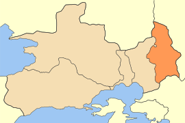
فيلي، أتيكي
Fyli
Φυλή | |
|---|---|
 | |
| الإحداثيات: 38°6′N 23°40′E / 38.100°N 23.667°E | |
| البلد | |
| المنطقة الادارية | Attica |
| الوحدة المحلية | West Attica |
| الحكومة | |
| • العمدة | Papous Christos (PASOK) |
| المساحة | |
| • البلدية | 109٫13 كم² (42٫14 ميل²) |
| • الوحدة البلدية | 69٫28 كم² (26٫75 ميل²) |
| المنسوب | 330 m (1٬080 ft) |
| التعداد (2011)[1] | |
| • البلدية | 45٬965 |
| • كثافة البلدية | 420/km2 (1٬100/sq mi) |
| • الوحدة البلدية | 2٬946 |
| • كثافة الوحدة البلدية | 43/km2 (110/sq mi) |
| منطقة التوقيت | UTC+2 (EET) |
| • الصيف (التوقيت الصيفي) | UTC+3 (EEST) |
| Postal code | 133 xx |
| مفتاح الهاتف | 210 |
| Vehicle registration | Z (as of 2006) |
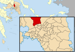
فيلي (باليونانية: Φυλή, تـُنطق [fiˈli]، وتعني "قبيلة"، Fyli) هي بلدة وبلدية في الجزء الشمالي الغربي من الوحدة المحلية غرب أتيكا، وضاحية من ضواحي أثينا في اليونان. مقر البلدية هو بلدة أنو ليوسيا.[2] ضمن حدود البلدة يقع الحصن الأثيني القديم فيلى.[3]
البلدية
The municipality Fyli was formed at the 2011 local government reform by the merger of the following 3 former municipalities, that became municipal units:[2]
- Ano Liosia
- Fyli
- Zefyri
تبلغ مساحة البلدية 109.128 km2, the municipal unit 69.281 km2.[4]
التاريخ
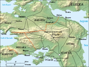
 خريطة فيلى أثناء حملة فيلى، 404 ق.م. |
The village has historically been an Arvanite settlement.[5]
A group of Athenian exiles, led by Thrasybulus, seized Phyle in the 404 BC Battle of Phyle. They went on to defeat the Spartan garrison at the Battle of Munichia near Piraeus.
Fyli suffered some damage from the 2007 Greek forest fires.
الجغرافيا
Fyli is situated in the southern foothills of the mountains of Parnitha, and northeast of the plain of Eleusis. It is 4 km northeast of Ano Liosia, 8 km northeast of Aspropyrgos and 14 km northwest of Athens city centre. Motorway 6 passes south of the town.
التعداد
| Year | Municipal unit | Municipality |
|---|---|---|
| 1981 | 2,135 | - |
| 1991 | 2,925 | - |
| 2001 | 2,947 | - |
| 2011 | 2,946 | 45,965 |
انظر أيضاً
المراجع
- ^ أ ب "Απογραφή Πληθυσμού - Κατοικιών 2011. ΜΟΝΙΜΟΣ Πληθυσμός" (in اليونانية). Hellenic Statistical Authority.
- ^ أ ب "ΦΕΚ A 87/2010, Kallikratis reform law text" (in اليونانية). Government Gazette.
- ^ Richard Talbert, ed. (2000). Barrington Atlas of the Greek and Roman World. Princeton University Press. p. 59, and directory notes accompanying. ISBN 978-0-691-03169-9.
- ^ "Population & housing census 2001 (incl. area and average elevation)" (PDF) (in اليونانية). National Statistical Service of Greece. Archived from the original (PDF) on 2015-09-21.
- ^ Pantelidis, Nikos; Liosis, Nikos (2019). "Dialectical Modern Greek Influences on Arvanitika". Modern Greek Dialects and Linguistics Theory. National and Kapodistrian University of Athens: 224.


