ضلع أبت أباد
ضلع أبت أباد | |
|---|---|
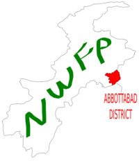
 خريطة هزارا، پاكستان موضخ عليها ضلع أبت أباد | |
| البلد | |
| إقليم | خيبر پختونخوا |
| العاصمة | أبت أباد |
| الحكومة | |
| • الناظم | ساردار حيدر زمان |
| • نائب الناظم | محمد جنيد تانولي[1] |
| المساحة | |
| • الإجمالي | 1٬969 كم² (760 ميل²) |
| التعداد (1998) | |
| • الإجمالي | 881٬000 |
| • الكثافة | 448/km2 (1٬160/sq mi) |
| منطقة التوقيت | UTC+5 (ت. پ.) |
| عدد مجالس الاتحاد | 51 |
| Number of Tehsils | 2 |
| الموقع الإلكتروني | http://www.abbottabad.gov.pk |
ضلع أبت آباد (أردو: ضلع ایبٹ آباد)، هو ضلع في إقليم خيبر پختونخوا، پاكستان. يشغل الضلع مساحة 1,969 كم وعاصمته مدينة أبوت أباد.[2] ويحده من الشمال منسيرة، ومن الشرق مظفر أباد، ومن الغرب هاريپور، ومن الجنوب روالپيندي.[3]
التاريخ
التسمية
سمي الضلع على اسم الضابط البريطاني جيمس أبوت، أول مفوض برطاني على هزارا (1849–1853).[3]
هزارا
أثناء الحكم البريطاني أصبحت أبوت أباد عاصمة لمنطقة هزارا، والتي سميت على اسم وادي هزارا، وهو وادي صغير خارج هيمالياس، يقع ما بين إندوس في الغرب وكشمير في الشرق.[4]
كان ضلع أبوت أباد في الأصل تحصيل هزارة، والذي وصفه المعجم الملكي في الهند كالتالي:
تحصيل ضلع هزارة، إقليم التخوم الشمالية الغربية، يقع ما بين 33°49' و 34° 22' شمالا. و72°55' و73° 31' شرقا، بمساحة 715 كم2. ويحده من الشرق Jhelum والذي ينقسم إلى Pūnch and the Punjab District of Rawalpindi; and it comprises part of the mountain valleys drained by the Dor and Harroh rivers, together with the hill country eastward. The hill-sides to the north and north-east are covered with timber forest. The population in 1901 was 194,632, compared with 175,735 in 1891. It contains the towns of ABBOTTABAD (population, 7,764), the tahsil and District head-quarters, and NAWASHAHR (4,114); and 359 villages. The land revenue and cesses amounted in 1903-4 to Rs. 97,000.[5]
As Hazara District covered a large area, the provincial government decided for administrative purposes to divide Hazara into Abbottabad, Mansehra, Kohistan, Haripur and Batagram districts. In 1981 Hazara was divided and Abbottabad was formed as a district with two tehsils. In 1981 the total area of District Abbottabad was 3،665 ميل مربع (9،490 km2) with a population of 977,212. Tehsil Abbottabad (a sub division of the district) - had an area of 1،802-ميل-مربع (4،670 km2) and a population of 667,328 including 51% of Circle Bakote. In 1990 the total population of the district was 1,425,032 including Circle Bakote 43%.
زلزال 2005
في أكتوبر 2005، ضرب زلزال ضلع أبت أباد، وتضررت تسعة مجالس اتحادية، وهي Dalola, Boi, Bakot, Pattan Kalan, Nambal, Berote, Kukmong, Palak and Beerangali والتي تقع على نهري جهلوم وجنهار.[6]
الديموغرافيا والمجتمع
حسب تقديرات تعداد عام 1998 وصل عدد لسكان الضلع 0.88 مليون نسمة- وحسب التقديرات فقد إرتفاع عدد السكان إلى 1.05 مليون في 2008.[7] القبائل الرئيسية في الضلع هي؛ Dhund Abbasies, Tanolis, Awans, Rajputs, Jadoons,Kashmiri, ] Maliar, Dhanyal, Sarrara, Qureshis, Karrlals, Sheikhs, Gujjars, and the Syeds.[8]
القمم الجبلية
Miranjani (3,313m) and Mukeshpuri are the highest peaks in Nathia Gali/Sajikot/Hairlan/Nara/Satora/Narwara in this district.
المنتزهات والمحميات
Under the Khyber Pakhtunkhwa Wildlife (Protection, Preservation, Conservation and Management) Act of 1975, two areas have been designated with the district: Ayubia National Park and Qalanderabad game reserve.[9] Both areas cover only 6% of the landed area of the district.[9]
منتزه أيوبيا الوطني
تأسس عام 1984، ويغطي المنتزه مساحة 3,312 هكتار.[9]
Qalanderabad game reserve
تأسس عام 1980 ويغطي مساحة 8,940 هكتار.[9]
المعادن
يوجد بعض المعادن في الضلع مثل barite, dolomite, گرانيت, gypsum, حجر جيري, magnesite, رخام, فوسفات, مغرة حمراء وأكسيد الحديد الأحمر.
التقسيمات
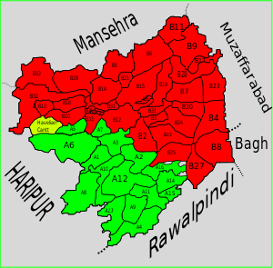
ينقسم ضلع أبت أباد إلى تحصيلين، أبت أباد وHavelian بالإضافة إلى منطقة حضرية واخدة - Nawanshehr. ويوجد 51 مجلس اتحادي في الضلغ 35 في تحصيل أبوت أباد و16 في Havelian. وهم:
تحصيل أبوت أباد
Khanispur ayubia Darwaza |
Havelian Tehsil
dobather
المجلس الاقليمي
| الدائرة الانتخابية | MPA | الحزب |
|---|---|---|
| PF-44 (Abbottabad-1) | Inayatullah Khan Jadoon | PML N |
| PF-45 (Abbottabad-2) | Sardar Shamun Ahmed Khan | PML N |
| PF-46 (Abbottabad-3) | Haji Qalandar Khan Lodhi | PML Q |
| PF-47 (Abbottabad-4) | Sardar Aurangzeb Khan Nalotha | PML N |
| PF-48 (Abbottabad-5) | Muhammad Javed Abbasi | PML N |
الجمعية الوطنية
| الدائرة الانتخابية | MNA | الحزب |
|---|---|---|
| NA-17 (Abbottabad-I) | Sardar Mehtab Ahmed Khan Abbasi | PML-N |
| NA-18 (Abbottabad-II) | Murtaza Javed Abbasi | PML-N 2nd |
الحكومة والسياسة
انتخابات 2008
الحملات السياسية
التعليم
أبت أباد
دائرة باكوته
Ayubia Chair Lifts
Dungagali
Nathiagali
Thandiani
Marhes
مشاهير
Hazrat Peer Syed Mahmood Shah Muhaddis Hazarvi Peer Syed Mohyuddin Mahboob Author and Chief Of Sadat And Ammer Of Saints Of Pakistan Mollana Qazi Nawaz Khan Jadoon, the Khateeb of Ilyasi Mosque, the most famous mosque of Pakistan in Abbottabad. Air Marshal (rtd) Asghar Khan. Dr.Syed Mehboob famous writer, researcher and columnist
- Yasir Hameed, Pakistani Cricketer
- Osama bin Laden
المصادر
- ^ Administration Department - Khyber Pukhtoonkhwa government website
- ^ Geography of District Abbottabad
- ^ أ ب IUCN Pakistan (2004). Abbottabad - State of the environment and Development. IUCN Pakistan and Khyber Pukhtoonkhwa: Karachi p. 2.
- ^ Hazara - Nordisk familjebok
- ^ Imperial Gazetteer of India, v. 5, p. 1
- ^ [EARTHQUAKE RECONSTRUCTION AND REHABILITATION AUTHORITY - ERRA]
- ^ District Profile: Northern Khyber Pakhtunkhwa - Abbottabad
- ^ ELECTIONS 2002 (Hazara Division) - Daily times Pakistan
- ^ أ ب ت ث IUCN Pakistan (2004). Abbottabad - State of the environment and Development. IUCN Pakistan and Khyber Pakhtunkhwa: Karachi p. 50.
- Pages using gadget WikiMiniAtlas
- Short description is different from Wikidata
- Pages using infobox settlement with unknown parameters
- Pages using infobox settlement with no coordinates
- Articles containing أردو-language text
- Pages using Lang-xx templates
- Articles with hatnote templates targeting a nonexistent page
- Coordinates on Wikidata
- ضلع أبت أباد

