سوڤا
سوڤا
सुवा Suva | |
|---|---|
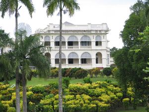
Suva Harbour, Central Business District, Government Buildings, WG Friendship Plaza Suva | |
| الشعار: Valataka na Dina (Fight for the Right) | |
 سوڤا في فيجي | |
| الإحداثيات: 18°08′30″S 178°26′31″E / 18.1416°S 178.4419°E | |
| البلد | |
| الجزيرة | ڤيتي لڤو |
| القسم | القسم الأوسط |
| المساحة | |
| • العاصمة | 791 ميل² (2٬048 كم²) |
| التعداد (2017) | |
| • العاصمة | 85٬691 |
| • Urban | 172٬399 |
| منطقة التوقيت | UTC+12 (1200 GMT) |
سوڤا (إنگليزية: Suva ؛ fj) هي عاصمة فيجي وأكبر مدنها. تقع على الساحل جنوب الشرقي لجزيرة ڤيتي لڤو، في القسم الأوسط، والتي هي عاصمتها كذلك. أصبحت سوفا عاصمة فيجي في 1877. عدد سكانها 167421 نسمة (1996).
In 1877, it was decided to make Suva the capital of Fiji. At that time, the colony was being administered from what had been the main European settlement: Levuka, on the Fijian island of Ovalau, in Lomaiviti Province. But the geography of Luvuka and its environs had proven too restrictive. The administration of the colony was transferred from Levuka to Suva in 1882.
As of the 2017 census, the city of Suva had a population of 93,970,[1] and Suva's metropolitan area, which includes the independent suburbs, had a population of 185,913.[2] The combined urban population of Suva and the towns of Lami, Nasinu, and Nausori that border it was around 330,000: over a third of the nation's population. (This urban complex, excluding Lami, is also known as the Suva-Nausori corridor.)
Suva is the political, economic, and cultural centre of Fiji. It is also the economic and cultural capital of the South Pacific, hosting the majority of the regional headquarters of major international corporations, international agencies, and diplomatic missions. The city also has a thriving arts and performance scene, and a growing reputation as the region's fashion capital.
التاريخ
In 1868, when Suva was still a small village, the Bauan chieftain, Seru Epenisa Cakobau, granted 5,000 km2 (1,900 sq mi) of land to the Australian-based Polynesia Company, in exchange for the company's promise to pay off debts owed to the United States. More than a tenth of this land area, 575 km2 (222 sq mi), was located near Suva. The company's original intention was to develop a cotton farming industry, but the land and climate proved unsuitable. [3]
In 1874, control of the Fiji Islands was ceded to the United Kingdom. In 1877, the colonial authorities decided to move the capital to Suva from Levuka, Ovalau, Lomaiviti, because Levuka's location between a steep mountain and the sea made any expansion of the town impractical. Colonel F.E. Pratt of the Royal Engineers was appointed Surveyor-General in 1875 and designed the new capital in Suva, assisted by W. Stephens and Colonel R.W. Stewart. The transfer to Suva was made official in 1882.[4]
In 1910, Suva acquired the status of a municipality, under the Municipal Constitution Ordinance of 1909. Its area remained one square mile until 1952, when Suva annexed the Muanikau and Samabula wards, expanding its territory to 13 km2 (5.0 sq mi). In October of that year, Suva was officially designated a city – Fiji's first. Suva later annexed Tamavua. Most recently, Suva further extended its boundaries by incorporating the Cunningham area at its northern edge. Since then, urban sprawl has led to the growth of a number of suburbs that remain outside the city limits. Together with the city, they form the metropolitan area known as the Greater Suva Area.[5]
Suva hosted the South Pacific Games in 2003 for the third time in the event's 40-year history. In preparation for hosting the event, the Fijian government, with the help of a $16 million aid package from the People's Republic of China, funded the construction of a new gymnasium, indoor sports centre, swimming pool, stadium, field hockey pitch, and grandstands in the area around Suva.[6]
الجغرافيا
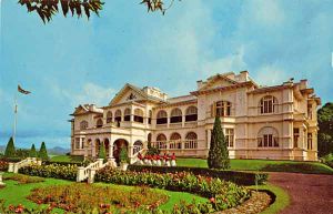
In addition to being the capital of Fiji, Suva is also its commercial and political centre (though not necessarily its cultural centre), and its main port city. It has a mix of modern buildings and colonial-period architecture.
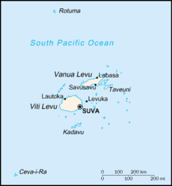
Suva is located around a harbour on a hilly peninsula in the southeast corner of Viti Levu Island, between Laucala Bay and Suva Harbour. The mountains to its north and west catch the southeast trade winds, producing year-round moist conditions.
Although Suva is on a peninsula, and almost surrounded by sea, its coast is lined with mangroves - the nearest beach is 40 kilometres (25 mi) away, at Pacific Harbour. A significant part of the city centre, including the Parliament buildings, is built on reclaimed mangrove swampland.
أحياء المدينة
Below is a list of the city's five wards,[7][مطلوب مصدر أفضل][8] beginning with the city centre, followed by the northwesternmost ward, and then in clockwise order:
- Central: city centre; mostly commercial, central business district
- Tamavua: urban; mostly residential
- Extension: semi-urban; residential
- Samabula: urban; residential, industrial, and commercial; has its own separate town centre; includes a university
- Muanikau: urban; mostly industrial and residential; includes large sporting venues, a university, and recreational areas
رواق سوڤا-ناوسوري
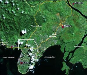
Suva sits in the middle of a metropolitan area, sometimes known as the Suva Urban Complex, and sometimes informally known as Suva, even though it encompasses a total of four areas with their own town or city names and their own separate local governments. This conurbation stretches from Lami (immediately west of the city of Suva) along the Queens Highway, through Nasinu (immediately east of the city of Suva), to the Rewa River, along the Kings Highway, and then to Nausori across the river. To the north and northeast are the rainforest-park areas of Colo-i-Suva and Sawani, along the Princes Road, which connect at the Rewa River Bridge. This whole area (excluding Lami) is also formally referred to as the Suva–Nausori Corridor. It is the most populous area in Fiji, with over 330,000 inhabitants.
المناخ
| سوڤا | ||||||||||||||||||||||||||||||||||||||||||||||||||||||||||||
|---|---|---|---|---|---|---|---|---|---|---|---|---|---|---|---|---|---|---|---|---|---|---|---|---|---|---|---|---|---|---|---|---|---|---|---|---|---|---|---|---|---|---|---|---|---|---|---|---|---|---|---|---|---|---|---|---|---|---|---|---|
| جدول طقس (التفسير) | ||||||||||||||||||||||||||||||||||||||||||||||||||||||||||||
| ||||||||||||||||||||||||||||||||||||||||||||||||||||||||||||
| ||||||||||||||||||||||||||||||||||||||||||||||||||||||||||||
| متوسطات الطقس لSuva, Fiji | |||||||||||||
|---|---|---|---|---|---|---|---|---|---|---|---|---|---|
| شهر | يناير | فبراير | مارس | أبريل | مايو | يونيو | يوليو | أغسطس | سبتمبر | اكتوبر | نوفمبر | ديسمبر | السنة |
| العظمى القياسية °C (°F) | 35 (95) | 36 (97) | 37 (99) | 34 (93) | 34 (93) | 32 (90) | 32 (90) | 32 (90) | 32 (90) | 34 (93) | 34 (93) | 36 (97) | 37 (99) |
| متوسط العظمى °م (°ف) | 29 (84) | 29 (84) | 29 (84) | 29 (84) | 28 (82) | 27 (81) | 26 (79) | 26 (79) | 27 (81) | 27 (81) | 28 (82) | 29 (84) | 29 (84) |
| متوسط الصغرى °م (°ف) | 23 (73) | 23 (73) | 23 (73) | 23 (73) | 22 (72) | 21 (70) | 20 (68) | 20 (68) | 21 (70) | 21 (70) | 22 (72) | 23 (73) | 20 (68) |
| الصغرى القياسية °م (°F) | 19 (66) | 19 (66) | 19 (66) | 16 (61) | 16 (61) | 14 (57) | 13 (55) | 14 (57) | 14 (57) | 14 (57) | 13 (55) | 17 (63) | 13 (55) |
| هطول الأمطار mm (بوصة) | 290 (11.4) | 272 (10.7) | 368 (14.5) | 310 (12.2) | 257 (10.1) | 170 (6.7) | 125 (4.9) | 211 (8.3) | 196 (7.7) | 211 (8.3) | 249 (9.8) | 318 (12.5) | 2٬977 (117٫2) |
| المصدر: http://www.bbc.co.uk/weather/world/city_guides/results.shtml?tt=TT004930 January 2010 | |||||||||||||
السكان
| 1986 | 1996 | 2007 | 2010 (estimate) | ||||||||
|---|---|---|---|---|---|---|---|---|---|---|---|
| Suva City | 141,273 | 167,975 | 85,691 | 85,691 | |||||||
| Official figures from population censuses | |||||||||||
المعالم
الاقتصاد
المؤسسات

المدن الشقيقة
 بـِيْهاي، گوانگشي، جمهورية الصين الشعبية[11]
 برايتون، أستراليا
 Guangdong, China
 Frankston, Australia
 Port Moresby, Papua New Guinea
 Shaoxing, China
 Yongsan, Seoul, South Korea
انظر أيضاً
الهامش
- ^ "Fiji Islands Bureau of Statistics – Population and Demography". Statsfiji.gov.fj. Retrieved 10 October 2012.
- ^ "2007 Census of Population and Housing". Retrieved 25 January 2017.
- ^ "ClimateFinder.com - Nausori, Fiji". www.climatefinder.com. Retrieved 2020-02-04.
- ^ "Europcar Fiji - Suva". www.europcar.com.fj. Retrieved 2020-02-04.
- ^ Nath, Shyam; Roberts, John L.; Madhoo, Yeti Nisha (2010). Saving Small Island Developing States: Environmental and Natural Resource Challenges. Commonwealth Secretariat. p. 164. ISBN 9781849290319.
- ^ "PATARA sponsors South Pacific Games 2003 and provides Information & Communications Technology for a "Smart Games"". patarapacific.com. Archived from the original on 4 August 2012. Retrieved 12 February 2020.
- ^ Narayan, Vidya (January 2002). "Rating Appraisal in Fiji Islands – Comparative Study of Unimproved Value and Proposed Improved Capital Value Rating Systems" (PDF). Pacific Rim Real Estate Society. p. 26.
- ^ "Suva City Council". suvacity.org. Retrieved 30 August 2023.
- ^ "Sister Cities". suvacity.org. Suva. Retrieved 2020-07-20.
- ^ "Sister-city relation to enhance trade". fijisun.com.fj. Fiji Sun. 2012-12-12. Retrieved 2020-07-20.
- ^ "About Beihai - Sister cities". Beihai Government. Retrieved 2008-11-25.
المصادر
- Fiji, by Korina Miller, Robyn Jones, Leonardo Pinheiro - Travel - 2003, published by Lonely Planet, pages 139-141, details on Suva City.
- The Suva City Library: A Brief History and Development, 1909–1980, by S Baksh - 1980
- Pluralism and Social Change in Suva City, Fiji, by Alexander Mamak - 1974, Thesis/dissertation; Ethnology (Fiji, Suva City); Suva City, Fiji Islands (Social conditions)
- A History of the Pacific Islands: Passages Through Tropical Time - Page 162, by Deryck Scarr 2001 - 323 pages.
- Frommer's South Pacific, by Bill Goodwin - Travel - 2004, pages 258-263
وصلات خارجية
 Suva travel guide from Wikivoyage
- Suva City Council (موقع رسمي)
- Pages using gadget WikiMiniAtlas
- Short description is different from Wikidata
- Pages using multiple image with auto scaled images
- Coordinates on Wikidata
- Articles containing إنگليزية-language text
- Pages using Lang-xx templates
- كل المقالات بدون مراجع موثوقة
- كل المقالات بدون مراجع موثوقة from August 2023
- Articles with hatnote templates targeting a nonexistent page
- سوڤا
- Capitals in Oceania
- Rewa Province
- أماكن مأهولة في فيجي
- موانئ أوقيانوسيا


