سوري، پارا
سوري
Soure | |
|---|---|
بلدية | |
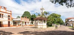
 Street in Soure, 2015 | |
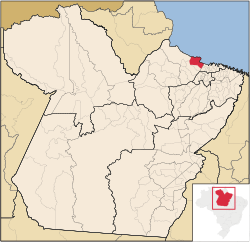
 Location in the State of Pará | |
| الإحداثيات: 00°43′01″S 48°31′22″W / 0.71694°S 48.52278°W | |
| البلد | |
| الإقليم | الشمالي |
| الولاية | |
| المساحة | |
| • الإجمالي | 3٬512٫863 كم² (1٬356٫324 ميل²) |
| المنسوب | 10 m (30 ft) |
| التعداد (2020 [1]) | |
| • الإجمالي | 25٬565 |
| • الكثافة | 6٫2/km2 (16/sq mi) |
| منطقة التوقيت | UTC−3 (BRT) |
| Postal Code | 68870-000 |
سوري Soure هي بلدية برازيلية في ولاية پارا الشمالية، في جزيرة ماراجو، الواقعة في مصب نهر الأمازون. في عام 2020 قـُدِر عدد سكانها بنحو 25,565 نسمة. مساحة البلدية هي 3,512.863 كم². المدينة هي جزء من mesoregion ماراجو وجزء من microregion of آراري.
تنحصر البلدية ضمن أرخبيل ماراجو، محمية بيئية البالغ مساحتها 59985 كم²، وهي وحدة استخدام مستدام للحفاظ على البيئة تأسست في 1989 لحماية بيئة منطقة الدلتا.[2] وتضم سوري، محمية الاستخلاص البحري البالغ مساحتها 27،464 هكتار (67،870 acre)، والمنشأة في 2001 لحماية أشجار القرم الساحلية إلى الشمال من مقر البلدية وبطول الجزء الشمالي من نهر پاراكاواري.[3]
أشخاص بارزون من سوري، پارا
- Ildemar Alcântara, Brazilian mixed martial artist, former UFC fighter and younger brother of Iuri Alcântara.
- Iuri Alcântara, Brazilian mixed martial artist, UFC fighter and older brother of Ildemar Alcântara.
- Deiveson Figueiredo, Brazilian mixed martial artist, UFC fighter, former two-time UFC Flyweight Champion.
- Zélia Amador, first black woman to be a vice-rector of a Brazilian university. Black rights activist.
المناخ
Soure has a tropical monsoon climate (Köppen: Am), with different amounts of precipitation depending on the season.[4][5]
| بيانات المناخ لـ سوري (1981–2010) | |||||||||||||
|---|---|---|---|---|---|---|---|---|---|---|---|---|---|
| الشهر | ينا | فب | مار | أبر | ماي | يون | يول | أغس | سبت | أكت | نوف | ديس | السنة |
| متوسط القصوى اليومية °س (°ف) | 30.3 (86.5) |
29.9 (85.8) |
29.9 (85.8) |
30.3 (86.5) |
31.0 (87.8) |
31.4 (88.5) |
31.3 (88.3) |
31.3 (88.3) |
31.6 (88.9) |
31.9 (89.4) |
32.0 (89.6) |
31.5 (88.7) |
31.0 (87.8) |
| المتوسط اليومي °س (°ف) | 27.0 (80.6) |
26.6 (79.9) |
26.5 (79.7) |
26.8 (80.2) |
27.3 (81.1) |
27.5 (81.5) |
27.5 (81.5) |
27.9 (82.2) |
28.3 (82.9) |
28.5 (83.3) |
28.6 (83.5) |
28.1 (82.6) |
27.6 (81.7) |
| متوسط الدنيا اليومية °س (°ف) | 24.3 (75.7) |
23.9 (75.0) |
23.9 (75.0) |
24.0 (75.2) |
24.4 (75.9) |
24.5 (76.1) |
24.5 (76.1) |
25.0 (77.0) |
25.6 (78.1) |
25.8 (78.4) |
25.9 (78.6) |
25.5 (77.9) |
24.8 (76.6) |
| متوسط تساقط الأمطار mm (inches) | 456.8 (17.98) |
537.6 (21.17) |
647.2 (25.48) |
561.5 (22.11) |
319.3 (12.57) |
185.8 (7.31) |
138.6 (5.46) |
79.3 (3.12) |
15.9 (0.63) |
14.6 (0.57) |
28.5 (1.12) |
150.5 (5.93) |
3٬135٫6 (123.45) |
| Average precipitation days (≥ 1.0 mm) | 19 | 22 | 25 | 24 | 20 | 16 | 14 | 8 | 2 | 2 | 2 | 7 | 161 |
| متوسط الرطوبة النسبية (%) | 83.9 | 86.8 | 87.4 | 87.5 | 84.9 | 81.8 | 80.4 | 78.0 | 74.9 | 73.9 | 74.5 | 77.9 | 81.0 |
| Mean monthly ساعات سطوع الشمس | 143.3 | 98.2 | 93.3 | 107.4 | 163.2 | 222.4 | 255.2 | 277.0 | 269.0 | 273.7 | 252.5 | 219.0 | 2٬374٫2 |
| Source 1: Instituto Nacional de Meteorologia[6] | |||||||||||||
| Source 2: NOAA[5] | |||||||||||||
المراجع
- ^ IBGE 2020
- ^ (in Portuguese)APA Arquipélago do Marajó, ISA: Instituto Socioambiental, https://uc.socioambiental.org/uc/951, retrieved on 2016-06-27
- ^ (in Portuguese)RESEX Marinha de Soure, ISA: Instituto Socioambiental, https://uc.socioambiental.org/uc/4370, retrieved on 2016-06-29
- ^ Hunter, Allice (2018-11-21), English: Köppen climate types of Pará, Brazil., https://commons.wikimedia.org/wiki/File:Par%C3%A1_K%C3%B6ppen.svg, retrieved on 2019-03-27
- ^ أ ب "Soure (82141) - WMO Weather Station". NOAA. Retrieved March 27, 2019.
- ^ "Normais Climatológicas Do Brasil 1981–2010" (in Portuguese). Instituto Nacional de Meteorologia. Retrieved 21 May 2024.
{{cite web}}: CS1 maint: unrecognized language (link)
?

