رامجرد
Ramjerd
فارسية: رامجرد | |
|---|---|
City | |
| الإحداثيات: 30°04′29″N 52°35′29″E / 30.07472°N 52.59139°E[1] | |
| البلد | إيران |
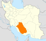
| المحافظة | فارس |
| المقاطعة | مرودشت |
| البخش | درودزن |
| التعداد (2016)[2] | |
| • الإجمالي | 2٬550 |
| منطقة التوقيت | UTC+3:30 (IRST) |
رامجرد (فارسية: رامجرد ؛ Ramjerd)[أ] هي مدينة في، وعاصمة، Dorudzan District of Marvdasht County, Fars province, Iran.[4] It also serves as the administrative center for Ramjerd-e Do Rural District.[5]
Demographics
Population
At the time of the 2006 National Census, the population was 2,033 in 446 households, when it was the village of Kushkak in Ramjerd-e Do Rural District.[6] The following census in 2011 counted 2,260 people in 566 households,[7] by which time the village had been elevated to the status of a city and renamed Ramjerd. The 2016 census measured the population of the city as 2,550 people in 713 households.[2]
See also
Notes
References
- ^ OpenStreetMap contributors (26 September 2023). "Ramjerd, Marvdasht County" (Map). OpenStreetMap (in الفارسية). Retrieved 26 September 2023.
- ^ أ ب "Census of the Islamic Republic of Iran, 1395 (2016)". AMAR (in الفارسية). The Statistical Center of Iran. p. 07. Archived from the original (Excel) on 6 April 2022. Retrieved 19 December 2022.
- ^ رامجرد can be found at GEOnet Names Server, at this link, by opening the Advanced Search box, entering "-3072600" in the "Unique Feature Id" form, and clicking on "Search Database".
- ^ Habibi, Hassan (29 March 1370). "Creation and establishment of rural districts and divisions in Fars province". Lamtakam (in الفارسية). Ministry of Interior, Council of Ministers. Archived from the original on 9 December 2023. Retrieved 9 December 2023.
- ^ Mousavi, Mirhossein. "Creation and formation of 17 rural districts including villages, farms and places in a part of Marvdasht County under Fars province". Research Center, the System of Laws of the Islamic Council of Farabi Library (in الفارسية). Ministry of Interior, Council of Ministers. Archived from the original on 2 June 2014. Retrieved 7 December 2023.
- ^ "Census of the Islamic Republic of Iran, 1385 (2006)". AMAR (in الفارسية). The Statistical Center of Iran. p. 07. Archived from the original (Excel) on 20 September 2011. Retrieved 25 September 2022.
- ^ "Census of the Islamic Republic of Iran, 1390 (2011)". Syracuse University (in الفارسية). The Statistical Center of Iran. p. 07. Archived from the original (Excel) on 16 January 2023. Retrieved 19 December 2022.
تصنيفات:
- Pages using gadget WikiMiniAtlas
- CS1 الفارسية-language sources (fa)
- Short description is different from Wikidata
- Articles containing فارسية-language text
- Coordinates on Wikidata
- Portal-inline template with redlinked portals
- Pages with empty portal template
- Cities in Fars Province
- Populated places in Marvdasht County


