رأس ابن هاني
| ||||||||||||||||||||||||||||||||
| ||||||||||||||||||||||||||||||||
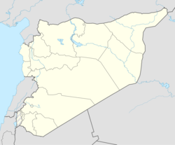
رأس ابن هاني هي أكثر رؤوس الساحل السوري بروزاً على شاطيء اللاذقية / سورية . يبعد عن مدينة اللاذقية 10 كم شمالا.
وفي المنطقة الكثير من المنشآت السياحية الكبيرة مثل ، منتجع الشاطيء الازرق والفنادق الدولية مثل فندق الميرديان والشاليهات والمسابح البحرية والقرى السياحية والمطاعم اضافة لقرية صيادين ومعهد للابحاث البحرية ،
في المنطقة اثار تاريخية هامة وهي مدينة اوغاريت التاريخية وهي مدينة ملكية التي قدمت للبشرية أول واقدم ابجدية في التاريخ ابجدية اوغاريت حيث تم العثور على قصرين و منشأة للصناعة للنعدين فيها قالب الصب الوحيد في العالم على شكل جلد الثور اضافة لنحصينات هيلينستية ومباني مميزة .
تتميز ابن هاني بجمال طبيعتها البحرية وتداخل اليابسة مع البحر واطلالة الجبال الساحلية الرائعة مما يعطي المنطقة المزيد من التآلق والروعة وتشتهر بنشاطها السياحي ، وتزدحم بالسياح والمصطافين طوال فترة الصيف .
تاريخ
This coastal site lies a two-hour walk from the site of Bronze Age Ugarit, and survived in modest fashion Ugarit's collapse at the end of the Bronze Age: "Ugarit's inhabitants dispersed, but no crisis could neutralize their invaluable asset, the coast's best natural harbour on the promontory of Ras ibn Hani; it became known from its low white cliff as the 'White Harbour' in later Greek coastal guidebooks, a name which persists in modern Arabic as Minet el-Beida", observes Robin Lane Fox,[1] who identified Ras Ibn Hani as the site later Greeks knew as Betyllion,[2] possibly a Hellenized version, he suggests, of the Semitic bait-El or "house of El, a name which, if that is the derivation, "confirms that Canaanite-Phoenician culture never entirely died at the site".
Robin Lane Fox notes[1] that the Roman emperor Trajan landed at this spot to join his troops in Syria for the fateful Mesopotamian campaigns of 114–117.
انظر أيضاً
المراجع
- ^ أ ب Fox, Travelling Heroes in the Epic Age of Homer, 2008:91.
- ^ Fox gives his source as John Malalas,'s Chronicon (11.3) written in the 6th century, which has the form Bytyllion, which is also the form reported in Barrington Atlas of the Greek and Roman World (Princeton) 2000.
ببليوگرافيا
- Cohen, Getzel M. (2006). The Hellenistic settlements in Syria, the Red Sea Basin, and North Africa. University of California Press. ISBN 978-0-520-24148-0.


