درع غيانا
درع گويانا
Guiana Shield | |
|---|---|
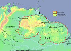 Political map of the Guiana Shield | |
| الإحداثيات: 5°08′36″N 60°45′45″W / 5.14333°N 60.76250°W | |
| المنطقة | أمريكا الجنوبية |
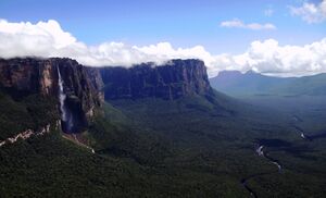
درع گويانا/غيانا Guiana Shield[1] (فرنسية: Plateau des Guyanes, Bouclier guyanais; هولندية: Hoogland van Guyana, Guianaschild; برتغالية: Planalto das Guianas, Escudo das Guianas؛ إسپانية: Escudo guayanés) هو أحد ثلاث كراتونات في صفيحة أمريكا الجنوبية. وهي تكوين جيولوجي قبل الكامبري عمره 1.7 مليار سنة، في شمال شرق أمريكا الجنوبية ويشكل جزءاً من ساحلها الشمالي.[2] المستويات الأعلى على الدرع تسمى مرتفعات گويانا، حيث توجد جبال مثل الموائد وتُدعى تيپوي. مرتفعات جويانا هي أيضاً منبع بعض أشهر شلالات العالم، مثل شلالات آنجل وKaieteur Falls و Cuquenan Falls.
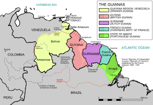
The Guiana Shield underlies Guyana (previously British Guiana), Suriname (previously Dutch Guiana), and French Guiana (or Guyane), much of southern Venezuela, as well as parts of Colombia and Brazil. The rocks of the Guiana Shield consist of metasediments and metavolcanics (greenstones) overlain by sub-horizontal layers of sandstones, quartzites, shales and conglomerates intruded by sills of younger mafic intrusives such as gabbros.[3]
وتعرف أيضا كمرتفعات گويانا أو درع گويانا الصخري، وهي إحدى مناطق أمريكا الجنوبية. تطل على المحيط الأطلسي والبحر الكاريبي. تكوين المنطقة الجيولوجي يحوي العديد من الجبال المسطحة التي تسمى تبوي التي تعد موطنا لأكثر شلالات العالم ارتفاعا كشلالات إنجل وشلالات كيوكيونان. تمتد المنطقة من وسط ڤنزويلا شمالا حتى شمال البرازيل جنوبا وشرقا حتى گويانا الفرنسية مارة بگويانا وسورينام.
الجيولوجيا
The oldest rocks in the shield consist of Archean Imataca Complex, composed of a quartz-feldspar gneiss and subordinate mafic gneiss. The Guri Fault marks the southern boundary of the complex. South of that fault are Early Proterozoic rocks consisting of the metavolcanic Pastora Supergroup and the granitic plutonic Supamo Complex. The Cuchivero Group consists of ash flow tuff and granitic plutonic rocks. The Early to Middle Proterozoic Roraima Group consists of continental clastic sedimentary rocks. These Precambrian sediments include quartz sandstones, quartzites, and conglomerates presumed to be 1.8 to 1.4 Ga in age.[4][5]
شكل الأرض
There are three upland areas of the Guiana Shield:
- The Guiana Highlands proper are in Venezuela east of the Orinoco and extend across much of west-central Guyana and into the northern Roraima state in Brazil.
- The Tumucumaque Uplands which are a series of central massifs in an arc from the Wilhelmina Mountains of south-central Suriname, along the southern boundary of Suriname and Guyana, forming the Acarai Mountains of Roraima state and the Tumuc-Humac Mountains of Pará and Amapá states of Brazil. From this arc, the southern uplands slope gently downwards towards the Amazon River and the northern uplands slope gently downwards toward the Atlantic.
- The Chiribiquete Plateau is a sandstone topped plateau with an elevation of 900 m (2،953 ft) that forms the western edge of the shield. The plateau is separated from the eastern Andes by the thick Neogene sediments of the Sub-Andean Trough that runs along the northern and western rim of the Guiana Shield.
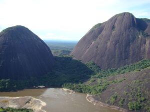
The north-central part of the Guiana Highlands is dominated by high flat-topped peaks called tepuis, of the Roraima supergroup and Quasi-Roraima formation, and the rounded granite peaks of the Parguaza and Imataca complexes to the north and southwestern edges of the area. The highest point in the shield is Pico da Neblina in Brazil at 2،995 متر (9،826 ft).[6] Pico da Neblina is the highest summit of the larger Neblina massif, a highly eroded sandstone plateau that straddles the Venezuela-Brazil border and that has lost the typical tabletop shape of the other tepuis in the region.[بحاجة لمصدر]
البيئة
The Guiana Shield is one of the regions of highest biodiversity in the world, and has many endemic species. The region houses over 3000 vertebrate species: 1168 fresh water fish, 269 amphibians (54% endemics), 295 reptiles (29%), 1004 birds (7.7%), and 282 mammals (11%).[7][8][9] Diversity of invertebrates remains largely undocumented, but there are several species of endemic butterflies and dung beetles.[10][11]
Plant life is equally rich and 13,367 species of vascular plants have been found, approximately 40% of which is considered endemic.[12] The shield is overlain by the largest expanse of tropical forest on any Precambrian shield area in the world.[13] Guianan rain forest is similar in nature to Amazonian rain forest and known protected areas include the Iwokrama Forest of central Guyana, Kaieteur, Kanuku National Park of southern Guyana, the UNESCO World Heritage Site Central Suriname Nature Reserve of Suriname, the Guiana Amazonian Park in French Guiana and the Tumucumaque National Park in the Amapá State of Brazil. In Venezuela the forests are protected by Canaima, Parima-Tapirapeco and Serranía de la Neblina national parks. In 2014, the Government of Colombia designated a 250 hectare area of the Guiana Shield, as a Ramsar Wetland, thus becoming a protected area of international importance in accordance to the Ramsar Convention.[14]
According to recent researches, although ecosystems of the Guayana Highlands remain vibrant, emerging issues (including "a well-known invasive plant elsewhere" Poa annua and "one of the most aggressive weeds" Polypogon elongatus) and infectious faecal bacteria Helicobacter pylori have been documented.[15]
انظر أيضاً
- Gran Sabana
- Tepui
- Canadian Shield
- Caribbean South America
- Monte Roraima
- Pico da Neblina
- Great American Interchange
- Geography of South America
المراجع
- ^ المصطلح گويانا أو الغيانات Guianas كثيراً ما يُستخدم كإسم جماعي لكل من گويانا, سورينام وگويانا الفرنسية بل وأحياناً تضم أجزاء من كولومبيا و ڤنزويلا والبرازيل (بما في ذلك معظم ولاية رورايما) which are on the Guiana Shield.
- ^ Hammond, David S. (ed.) (2005) Tropical Forests of the Guiana Shield CABI Publishing, Wallingford, UK, ISBN
- ^ Gibbs, A.K. and Barron,C.N. (eds) (1993) The Geology of the Guiana Shield Oxford University Press, Oxford, UK, ISBN
- ^ Geology and Mineral Resource Assessment of the Venezuelan Guayana Shield, USGS Bulletin 2062. US Government Printing Office. 1993. pp. 10–15.
- ^ Wray, Robert (2010). Migon, Piotr (ed.). The Gran Sabana: The World's Finest Quartzite Karst?, in Geomorphological Landscapes of the World. Springer. pp. 80–81. ISBN 9789048130542.
- ^ "Geociências: IBGE revê as altitudes de site Pontos culminates" [Geosciences: IBGE revises the altitude of seven high points] (Press release) (in البرتغالية). Brasília: Brazilian Institute of Geography and Statistics (IBGE). 2016-02-29. Retrieved 2016-03-02.
- ^ Hollowell, T.; Reynolds, R.P. (2005). "Checklist of the Terrestrial Vertebrates of the Guiana Shield" (PDF). Bulletin of the Biological Society of Washington. 13.
- ^ Stachowicz, Izabela; Ferrer Paris, José Rafael; Quiroga-Carmona, Marcial; Moran, Lisandro; Lozano, Cecilia (2020). "Baseline for monitoring and habitat use of medium to large non-volant mammals in Gran Sabana, Venezuela". Therya. 11 (2): 169–179. doi:10.12933/therya-20-891.
- ^ Vari, R.P.; Ferraris Jr., C.J.; Radosavljevic, A.; Funk, V.A. (2009). "Checklist of the freshwater fishes of the Guiana Shield" (PDF). Bulletin of the Biological Society of Washington. 17.
- ^ Ferrer-Paris, José R; Lozano, Cecilia; Cardozo-Urdaneta, Arlene; Thomas Cabianca, Arianna (2016). "Indicative response of Oxysternon festivum Linné (Coleoptera: Scarabaidae) to vegetation condition in the basin of the Orinoco river, Venezuela". Journal of Insect Conservation. 20 (3): 527–538. doi:10.1007/s10841-016-9886-6. S2CID 17263106.
- ^ Costa, Mauro; Viloria, Ángel L.; Hubber, Otto; Attal, Stéphane; Orellana, Andrés (2013). "Lepidoptera del Pantepui. Parte I: Endemismo y caracterización biogeográfica". Entomotropica. 28 (3): 193–217. Archived from the original on 27 August 2016. Retrieved 25 June 2016.
- ^ Funk, V.; Hollowell, T.; Berry, P.; Kelloff, C.; Alexander, S.N. (2007). "Checklist of the Plants of the Guiana Shield (Venezuela: Amazonas, Bolivar, Delta Amacuro; Guyana, Surinam, French Guiana)" (PDF). Contributions from the United States National Herbarium. 55.
- ^ Hammond, David S. (ed.) (2005) Tropical Forests of the Guiana Shield CABI Publishing, Wallingford, UK, ISBN
- ^ "Colombia | Ramsar".
- ^ Rull, V.; Vegas-Vilarrúbia, T.; Safont, E. (2016). "The Lost World's pristinity at risk" (PDF). Diversity and Distributions. 22 (10): 995–999. doi:10.1111/ddi.12469. hdl:10261/137349. S2CID 23002053.
وصلات خارجية
 Media related to Guiana Shield at Wikimedia Commons
 وسائط متعلقة بـGuiana Highlands من مشاع المعرفة.
 Media related to Tepuis at Wikimedia Commons
- Pages using gadget WikiMiniAtlas
- CS1 البرتغالية-language sources (pt)
- Short description is different from Wikidata
- Coordinates on Wikidata
- Pages using infobox settlement with missing country
- Pages using infobox settlement with no map
- Articles containing فرنسية-language text
- Pages using Lang-xx templates
- Articles containing هولندية-language text
- Articles containing برتغالية-language text
- Articles containing إسپانية-language text
- Articles with unsourced statements from August 2015
- التاريخ الطبيعي لأمريكا الجنوبية
- مناطق مقسمة
- كراتونات
- جغرافيا گويانا
- المناطق الجغرافية في ڤنزويلا
- مناطق أمريكا الجنوبية
- أقاليم فيزيوغرافية
- بذرة جغرافيا أمريكا الجنوبية
