جغرافيا إسواتيني
جغرافيا سوازيلاند
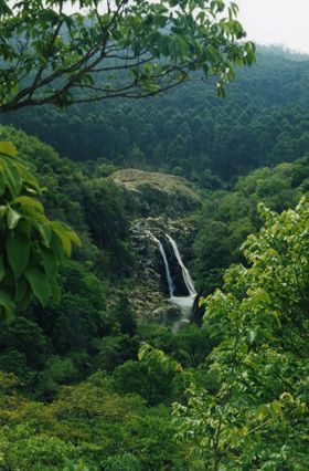
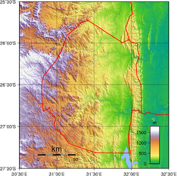
ترتفع الجبال على طول الحدود الغربية لسوازيلاند إلى حوالي 1,370م فوق سطح البحر وتغطي غابات الصنوبر الواسعة جانبًا كبيرًا من الأراضي. ويبلغ متوسط درجة الحرارة 16°م وتتراوح كمية المطر ما بين 114 سم و191 سم سنويًا. وإلى الشرق من الجبال توجد مرتفعات متعرجة داخلية تغطيها الأعشاب. يعيش في هذه المنطقة معظم السكان في البلاد. يبلغ متوسط درجة الحرارة 19°م. وتتراوح كمية الأمطار السنوية ما بين 76 سم و114 سم. أما في أقصى الشرق فيستوي السطح أكثر فأكثر على هيئة سهل منخفض تغطيه الحشائش والشجيرات الخفيفة ويبلغ متوسط درجة الحرارة 22°م وتصل كمية المطر السنوي إلى 50 سم فقط. وعلى طول الحدود الشرقية ترتفع جبال لمبوبو الشاهقة الضيقة.
تُعد سوازيلاند من أفضل المناطق مياهًا في الجنوب الإفريقي، إذ تجري عبر البلاد في اتجاه الشرق أربعة أنهار رئيسية وهي إنجوافوما، وأمبلوزي، وكوماتي، وأوسوتو الكبير. وتوفر هذه الأنهار المياه المطلوبة لري المحاصيل وتشغيل محطات توليد القدرة الكهرومائية.
. . . . . . . . . . . . . . . . . . . . . . . . . . . . . . . . . . . . . . . . . . . . . . . . . . . . . . . . . . . . . . . . . . . . . . . . . . . . . . . . . . . . . . . . . . . . . . . . . . . . . . . . . . . . . . . . . . . . . . . . . . . . . . . . . . . . . . . . . . . . . . . . . . . . . . . . . . . . . . . . . . . . . . . .
المناخ
The average temperatures at Mbabane, according to seasons:
| Spring | September – October | 18 °C (64.4 °F) |
| Summer | November – March | 20 °C (68 °F) |
| Autumn | April – May | 17 °C (62.6 °F) |
| Winter | June – August | 13 °C (55.4 °F) |
الجغرافيا الطبيعية
The terrain largely consists of mountains and hills, with some moderately sloping plains. The lowest point is the Great Usutu River, at 21 metres, and the highest is Emlembe, at 1,862 m.
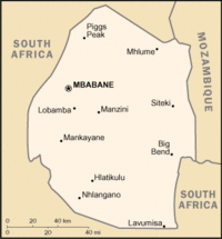
As a landlocked country, Swaziland has neither coastline nor maritime claims. In terms of land boundaries, Swaziland borders Mozambique for 105 kilometres, and South Africa for 430, giving a total land boundary length of 535 km.
الثروات الطبيعية
Swaziland possesses the following natural resources: asbestos, coal, clay, cassiterite, hydropower, forests, small gold and diamond deposits, quarry stone, and talc.
670 km² of the country's land is irrigated. The following table describes land use in Swaziland.
| Use | Percentage of Area |
|---|---|
| arable land | 9.77 |
| permanent crops | 0.7 |
| other | 89.53 |
النقاط القصوى
This is a list of the extreme points of Swaziland, the points that are farther north, south, east or west than any other location.
- Northernmost point - unnamed location of the border with South Africa immediately north of the village of Horo, Hhohho District
- Easternmost point - the tripoint with South Africa and Mozambique, Lubombo District
- Southernmost point - unnamed location on the border with South Africa, Shiselweni District
- Westernmost point - a longitudinal segment of the border with South Africa, Manzini District (not a single point)
وصلات خارجية
- European Digital Archive on the Soil Maps of the world - soil maps of Swaziland


