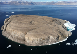
جزيرة هانز
| جزيرة متنازع عليها Native name: Tartupaluk, ᑕᕐᑐᐸᓗᒃ أسماء أخرى: Hans Ø, Île Hans | |
|---|---|
 Hans Island from the east (Greenland) side | |
| الجغرافيا | |
 خريطة جزء من قنال كندي، وفيه الجزيرة المتنازَع عليها. | |
| الموقع | قنال كندي في مضيق نارس |
| الإحداثيات | 80°49′41″N 66°27′35″W / 80.82806°N 66.45972°W |
| المساحة | 1.3 كم² |
| الطول | 1،290 m (0.80 mi) |
| العرض | 1،199 m (0.745 mi) |
| يطالب بها | |
| كندا | |
| الدنمارك | |
| الديمغرافيا | |
| التعداد | Uninhabited |
جزيرة هانز (إنگليزية: Hans Island؛ بالگرينلاندية: Tartupaluk؛ Inuktitut: ᑕᕐᑐᐸᓗᒃ; فرنسية: Île Hans؛ دنماركية: Hans Ø) هي small, uninhabited barren knoll measuring 1.3 km2 (0.5 sq mi), 1،290 متر (0.80 mi) long and 1،199 متر (0.745 mi) wide, وتقع في وسط قنال كندي في مضيق نارس—المضيق الذي يفصل جزيرة إلسمير عن شمال گرينلاند ويربط خليج بافن بـبحر لنكون. Hans Island is the smallest of three islands located in Kennedy Channel; the others are Franklin Island and Crozier Island. The strait is 35 كيلومتر (22 mi) wide here, placing the island within the territorial waters of both Canada and Denmark. A theoretical line in the middle of the strait goes through the island.
The island has likely been part of Inuit hunting grounds since the 14th century.[1] It is claimed by Canada, and by Denmark on behalf of the Greenland self-government.[2] In accordance with the home rule treaty, Denmark handles certain foreign affairs, such as border disputes, on behalf of the entire commonwealth. The nearest populated places are Alert, Canada (198 km/123 mi distance), Siorapaluk, Greenland (349 km/217 mi distance) and Qaanaaq, Greenland (379 km/235 mi distance).
انظر أيضاً
الهامش
- ^ "Whose Hans?". Canadian Geographic.
- ^ McKernan, Bethan (13 November 2015). "Canada and Denmark are locked in an adorable war". i100.co.uk. Retrieved 14 November 2015.
المصادر
- United Nations: Delimitation Treaties. Agreement between the Government of the Kingdom of Denmark and the Government of Canada relating to the Delimitation of the Continental Shelf between Greenland and Canada, December 17, 1973,
- U.S. Department of State: Bureau of Intelligence and Research Limits in the Seas No. 72 Continental shelf Boundary: Canada – Greenland, Issued by the Geographer, August 4, 1976.
- Hans Island rightfully belongs to Greenland, Denmark – Kenn Harper, Article, Nunatsiaq News, April 9, 2004.
- Agreement between the Government of Canada and the Kingdom of Denmark for Cooperation relating to the Marine Environment, August 26, 1983.
- Narrative of the North Polar expedition : U.S Ship Polaris, Captain Charles Francis Hall commanding, edited under the direction of G. M. Robeson by C. H. Davis. Washington, G. P. O., 1876.
وصلات خارجية
- Hans Island in the Atlas of Canada – Toporama; Natural Resources Canada
- Hans Island: A border dispute between Denmark and Canada – Background, maps, timeline about the Hans Island dispute.
- NPR's Morning Edition, Friday, Aug 12, 2005 – Summary of the dispute.
- Newsletter No.3 HDMS Triton – about the August 1, 2003 landing on the island.
- CASR – article on the dispute by the Canadian American Strategic Review.
- Caryophyllaceae of the Canadian Arctic Archipelago
- Canadian Archipelago Throughflow Study
- Crisis in the Arctic!
- Canadian perspective, March 29, 2004 (updated)
- The Globe and Mail: Denmark won't provoke 'flag war' over Hans Island
- Pages using gadget WikiMiniAtlas
- Articles containing إنگليزية-language text
- Pages using Lang-xx templates
- Articles containing فرنسية-language text
- Articles containing دنماركية-language text
- Canada–Greenland border
- جزر متنازع عليها
- Queen Elizabeth Islands
- Territorial disputes of Canada
- Territorial disputes of Denmark
- Uninhabited islands of Greenland
- Uninhabited islands of Qikiqtaaluk Region