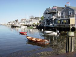
نانتكت
بلدة ومقاطعة نانتكت، مساتشوستس | |
|---|---|
 نانتكت | |
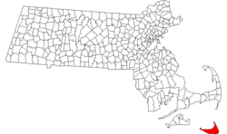
 موقع جزيرة ومقاطعة نانتكت في مساتشوستس | |
| الإحداثيات: 41°17′N 70°5′W / 41.283°N 70.083°W | |
| البلد | الولايات المتحدة |
| الولاية | مساتشوستس |
| استُوطِنت | 1641 |
| أشهرت | 1671 |
| الحكومة | |
| • النوع | لقاء مفتوح للبلدة |
| المساحة | |
| • الإجمالي | 272٫6 كم² (105٫3 ميل²) |
| • البر | 123٫8 كم² (47٫8 ميل²) |
| • الماء | 148٫8 كم² (57٫5 ميل²) |
| المنسوب | 9 m (30 ft) |
| التعداد (2010) | |
| • الإجمالي | 10٬172 |
| • الكثافة | 82٫2/km2 (212٫8/sq mi) |
| منطقة التوقيت | UTC-5 (Eastern) |
| • الصيف (التوقيت الصيفي) | UTC-4 (Eastern) |
| ZIP codes | 02554, 02564, 02584 |
| مفتاح الهاتف | 508 Exchanges: 228, 271, 325, 825 |
| FIPS code | 25-43790 |
| GNIS feature ID | 0619376 |
| الموقع الإلكتروني | www.nantucket-ma.gov |
نانتكت Nantucket /ˌnænˈtʌk[invalid input: 'ɨ']t/ هي جزيرة على بعد 48 كم جنوب كيپ كد، مساتشوستس، في الولايات المتحدة. مع الجزيرتين الصغيرتين تكرنك ومسكگت، تشكل بلدة نانتكت، مساتشوستس، مقاطعة نانتكت المطابقة. جزء من البلدة رُسـِّمت نانتكت (مكان تعداد). منطقة سرفسايد في نانتكت هي أقصى المستوطنات جنوباً في مساتشوستس.
الاسم، نانتكت، مأخوذ من أسماء ألگونكوين مشابهة للجزيرة، ربما تعني "الأرض أو الجزيرة البعيدة".
نانتكت هي مقصد سياحي ومستعمرة صيفية. إذ يزداد تعداد الجزيرة من حوالي 10,000 إلى 50,000 في شهور الصيف، بسبب السواح والسكان الموسميين.[1] في 2008، ذكرت مجلة فوربس نانتكت لكونها ضمن الأماكن ذات أعلى قيمة للبيوت في الولايات المتحدة.[2]
وتذكر مصلحة المنتزهات الوطنية نانتكت، المنطقة التاريخية، التي تضم كامل جزيرة نانتكت، لكونها "أفضل مثال معماري وبيئي باقي لبلدة مرفأ بحري بنيو إنگلاند من أواخر القرن 18 وأوائل القرن 19".[3]
التاريخ
أصل الاسم
نانتكت تأخذ اسمها على الأغلب من كلمة في لغة وامپانواگ، تـُكتب بطرق مختلفة كالتالي natocke, nantaticu, nantican, nautica أو natockete، التي هي جزء من تراث وامپانواگ عن خلق جزيرتي مارثاز ڤنيارد ونانتكت.[4] معنى الكلمة غير أكيد، إلا أنه قد يعني "في وسط المياه"، أو "الجزيرة البعيدة". وامپانواگ هي احدى لغات الألگونكوين الشرقية في جنوب نيو إنگلاند.[5]
كنية نانتكت، "سيدة البحر الرمادية الصغيرة The Little Grey Lady of the Sea"، تشير إلى الجزيرة كما تبدو من المحيط حين يلفها الغمام.[6][7]
الجيولوجيا والجغرافيا

تشكلت نانتكت من أقصى مدى لـصفحة الجليد اللورنتية أثناء تجلد وسكنسن الأخير، وتواصل التشكل بالارتفاع اللاحق في مستوى البحر. الرصيف المنخفض عبر القطاع الشمالي للجزيرة وترسب كـركام جليدي أثناء فترة من الركود الجليدي، وهي الفترة التي تتابع فيها وصول till مع ذوبان المثلجة عند جبهة متوقفة. الجزء الجنوبي من الجزيرة هو سهل طرح البحر، يميل مبتعداً عن قوس الركام وتشكل هامشه بأفعال النخل والنقل التي قام بها انجراف لونگشور. وقد أصبحت نانتكت جزيرة حين عادت مستويات البحر المتزايدة لغمر خليج بزردز منذ نحو 5,000–6,000 سنة مضت.[8]
| بيانات المناخ لـ نانتكت (نانتكت، المطار التذكاري) | |||||||||||||
|---|---|---|---|---|---|---|---|---|---|---|---|---|---|
| الشهر | ينا | فب | مار | أبر | ماي | يون | يول | أغس | سبت | أكت | نوف | ديس | السنة |
| متوسط القصوى اليومية °ف (°س) | 37.8 (3.2) |
39.4 (4.1) |
44.2 (6.8) |
51.9 (11.1) |
60.1 (15.6) |
67.9 (19.9) |
74.9 (23.8) |
75.0 (23.9) |
70.2 (21.2) |
60.7 (15.9) |
52.7 (11.5) |
44.1 (6.7) |
56.6 (13.7) |
| المتوسط اليومي °ف (°س) | 31.4 (−0.3) |
33.2 (0.7) |
37.8 (3.2) |
45.2 (7.3) |
53.4 (11.9) |
61.9 (16.6) |
68.6 (20.3) |
68.6 (20.3) |
63.6 (17.6) |
54.3 (12.4) |
46.4 (8.0) |
37.7 (3.2) |
50.2 (10.1) |
| متوسط الدنيا اليومية °ف (°س) | 24.9 (−3.9) |
27.0 (−2.8) |
31.4 (−0.3) |
38.6 (3.7) |
46.6 (8.1) |
55.8 (13.2) |
62.3 (16.8) |
62.3 (16.8) |
57.1 (13.9) |
47.8 (8.8) |
40.2 (4.6) |
31.2 (−0.4) |
43.8 (6.6) |
| متوسط تساقط الأمطار inches (mm) | 2.86 (73) |
2.16 (55) |
3.57 (91) |
3.51 (89) |
3.16 (80) |
3.02 (77) |
2.38 (60) |
2.91 (74) |
3.66 (93) |
3.80 (97) |
3.49 (89) |
3.46 (88) |
37.97 (964) |
| Average precipitation days (≥ 0.01 in) | 11.3 | 9.1 | 10.2 | 11.8 | 10.6 | 12.4 | 13.9 | 14.5 | 13.3 | 12.6 | 11.6 | 11.8 | 143.1 |
| Source: NOAA[9] | |||||||||||||
الديمغرافيا
| السنة | تعداد | ±% |
|---|---|---|
| 1850 | 8٬452 | — |
| 1860 | 6٬094 | −27.9% |
| 1870 | 4٬123 | −32.3% |
| 1880 | 3٬727 | −9.6% |
| 1890 | 3٬268 | −12.3% |
| 1900 | 3٬006 | −8.0% |
| 1910 | 2٬962 | −1.5% |
| 1920 | 2٬797 | −5.6% |
| 1930 | 3٬678 | +31.5% |
| 1940 | 3٬401 | −7.5% |
| 1950 | 3٬484 | +2.4% |
| 1960 | 3٬559 | +2.2% |
| 1970 | 3٬774 | +6.0% |
| 1980 | 5٬087 | +34.8% |
| 1990 | 6٬012 | +18.2% |
| 2000 | 9٬520 | +58.3% |
| 2010 | 10٬172 | +6.8% |
المصدر: سجلات تعداد الولايات المتحدة وبيانات برنامج تقديرات السكان.[10][11][12][13][14][15][16][17][18][19] | ||
المواصلات

From 1900 to 1918, Nantucket was one of few jurisdictions in the United States that banned automobiles.[20]
Nantucket Range Lights في نقطة برانت
في الخيال الشعبي
- رواية موبي ديك تدور حول صيادي حيتان من نانتكت.
الهامش
- ^ "Town and County of Nantucket - About Nantucket". nantucket-ma.gov. 2012 [last update]. Retrieved September 4, 2012.
{{cite web}}: Check date values in:|year=(help) - ^ Woolsey, Matt (7 October 2008), "America's Most Expensive ZIP Codes", Forbes.com, http://www.forbes.com/2008/09/28/zip-expensive-hundred-forbeslife-cx_richzipcodes08_mw_1007realestate.html, retrieved on 2012-12-31
- ^
Staff. "Nantucket Historic District". Maritime History of Massachusetts. National Park Service. Retrieved 2013-04-08.
{{cite web}}: Cite has empty unknown parameter:|coauthors=(help) - ^ Laverte, Suzanne; Orr, Tamra (2009). Massachusetts. Tarrytown, New York: Marshall Cavendish. p. 38. ISBN 978-0-7614-3005-6.
- ^ Huden, John C. (1962). Indian Place Names of New England. New York: Museum of the American Indian. Cited in: Bright, William (2004). Native American Place Names in the United States. Norman: University of Oklahoma Press, pg. 312
- ^ Morris, Paul C. (1996-07-01). Maritime Nantucket: A Pictoral History of the "Little Grey Lady of the Sea". Lower Cape Publishers. p. 272.
- ^
Editors (1937-08-09). "60,000 Summer visitors replace whalers on salty Martha's Vineyard & Nantucket". Life Magazine: 34–39. Retrieved 2013-04-08.
{{cite journal}}:|last=has generic name (help); Cite has empty unknown parameter:|coauthors=(help) - ^ أحدث مسح لجيولوجيا كيپ كد والجزر، متاح للقارئ العام، هو كتاب Robert N. Oldale, Cape Cod, Martha's Vineyard & Nantucket: The Geologic Story, 2001.
- ^ "NOWData - NOAA Online Weather Data". National Oceanic and Atmospheric Administration. Retrieved 2012-07-13.
- ^ "TOTAL POPULATION (P1), 2010 Census Summary File 1, All County Subdivisions within Massachusetts". United States Census Bureau. Retrieved September 13, 2011.
- ^ "Massachusetts by Place and County Subdivision - GCT-T1. Population Estimates". United States Census Bureau. Retrieved July 12, 2011.
- ^ "1990 Census of Population, General Population Characteristics: Massachusetts" (PDF). US Census Bureau. 1990. Table 76: General Characteristics of Persons, Households, and Families: 1990. 1990 CP-1-23. Retrieved July 12, 2011.
{{cite web}}: Unknown parameter|month=ignored (help) - ^ "1980 Census of the Population, Number of Inhabitants: Massachusetts" (PDF). US Census Bureau. 1981. Table 4. Populations of County Subdivisions: 1960 to 1980. PC80-1-A23. Retrieved July 12, 2011.
{{cite web}}: Unknown parameter|month=ignored (help) - ^ "1950 Census of Population" (PDF). Bureau of the Census. 1952. Section 6, Pages 21-10 and 21-11, Massachusetts Table 6. Population of Counties by Minor Civil Divisions: 1930 to 1950. Retrieved July 12, 2011.
- ^ "1920 Census of Population" (PDF). Bureau of the Census. Number of Inhabitants, by Counties and Minor Civil Divisions. Pages 21-5 through 21-7. Massachusetts Table 2. Population of Counties by Minor Civil Divisions: 1920, 1910, and 1920. Retrieved July 12, 2011.
- ^ "1890 Census of the Population" (PDF). Department of the Interior, Census Office. Pages 179 through 182. Massachusetts Table 5. Population of States and Territories by Minor Civil Divisions: 1880 and 1890. Retrieved July 12, 2011.
- ^ "1870 Census of the Population" (PDF). Department of the Interior, Census Office. 1872. Pages 217 through 220. Table IX. Population of Minor Civil Divisions, &c. Massachusetts. Retrieved July 12, 2011.
- ^ "1860 Census" (PDF). Department of the Interior, Census Office. 1864. Pages 220 through 226. State of Massachusetts Table No. 3. Populations of Cities, Towns, &c. Retrieved July 12, 2011.
- ^ "1850 Census" (PDF). Department of the Interior, Census Office. 1854. Pages 338 through 393. Populations of Cities, Towns, &c. Retrieved July 12, 2011.
- ^ Nantucket Historical Association
وصلات خارجية
- CS1 errors: generic name
- CS1 errors: unsupported parameter
- Short description is different from Wikidata
- Pages using gadget WikiMiniAtlas
- صفحات تستخدم جدول مستوطنة بقائمة محتملة لمفاتيح الهاتف
- Pages using infobox settlement with unknown parameters
- Ill-formatted IPAc-en transclusions
- Articles with hatnote templates targeting a nonexistent page
- كيپ كد والجزر
- نانتكت، مساتشوستس
- مقار مقاطعات مساتشوستس
- مقاطعات مساتشوستس
- أماكن ساحلية مأهولة في مساتشوستس
- جزر مساتشوستس
- أماكن مأهولة تأسست في 1641
- موانئ ساحل الأطلسي للولايات المتحدة
- تضاريس مقاطعة نانتكت، مساتشوستس
- تأسيسات 1641 في المستعمرات الثلاثةعشر


