جزيرة كوتلني
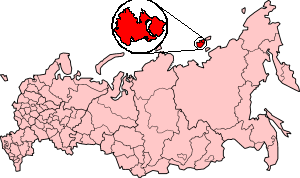
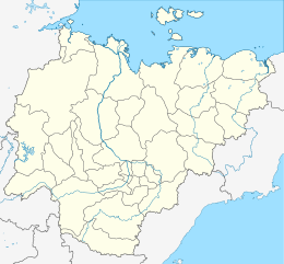
 Location of Kotelny Island in the Russian Federation | |
| الجغرافيا | |
|---|---|
| الموقع | East Siberian Sea |
| الإحداثيات | 75°20′N 141°00′E / 75.333°N 141.000°E |
| الأرخبيل | New Siberian Islands |
| إجمالي الجزر | 7 |
| الجزر الرئيسية | 3 |
| المساحة | 23،165 km2 (8،944 sq mi) |
| أعلى منسوب | 361 m (1٬184 ft) |
| أعلى نقطة | Malakatyn-Tas |
| الإدارة | |
Russia | |
| Republic | Yakutia |
| السكان | |
| التعداد | 2 (2017) |
| الكثافة السكانية | 0٫000086 /km2 (0٫000223 /sq mi) |
| الجماعات العرقية | None |
جزيرة كوتلني (روسية: Остров Котельный, النطق Ostrov Kotelny؛ بالياقوتية: Олгуйдаах Aрыы؛ إنگليزية: Kotelny Island) هي جزء من المجموعة الفرعية جزر آنژو ضمن الجزر السيبيرية الجديدة الواقعة بين بحر لاپتيڤ و بحر شرق سيبريا في المحيط القطبي الشمالي الروسي. وتتبع ادارياً وبلدياً Bulunsky District.
Kotelny, Faddeyevsky and Bunge Land are usually named as separate islands on most 20th century maps, although sometimes on the newest maps the name "Kotelny" is applied to the whole island. A flat, low-lying, plain connecting both is known as Bunge Land (روسية: Земля Бунге).
The total area of Kotelny Island is 23,165 km2.[1] Kotelny is one of the 50 largest islands in the world.[2] These merged islands are a practically uninhabited territory belonging to Yakutia of the Russian Federation.
التاريخ
The island was officially discovered by a Russian merchant and hunter, Ivan Lyakhov, with the merchant Protod’yakonov, in 1773. In 1770, Ivan Lyakhov noticed reindeer tracks heading seaward across the sea ice. In 1773, he and Protod’yakonov discovered the Lyakhovsky Islands by boat using the bearing of these tracks. Continuing from the Lyakhovsky Islands, they discovered Kotelny Island and named it "Kettle Island" after a copper kettle, which they found while exploring it. The person(s), who visited Kotelny Island and left the copper kettle, is unknown.[3] Formerly this island had been known as "Thaddeus Island" or "Thaddeus Islands" in some maps.
الجزر المجاورة
الجيولوجيا
المناخ
Kotelny Island has a harsh arctic climate, with temperatures only reaching above freezing briefly in the short summer months.
| بيانات المناخ لـ جزيرة كوتلني | |||||||||||||
|---|---|---|---|---|---|---|---|---|---|---|---|---|---|
| الشهر | ينا | فب | مار | أبر | ماي | يون | يول | أغس | سبت | أكت | نوف | ديس | السنة |
| القصوى القياسية °س (°ف) | −7.2 (19.0) |
−3.3 (26.1) |
−4.8 (23.4) |
1.2 (34.2) |
6.2 (43.2) |
22.4 (72.3) |
25.1 (77.2) |
20.2 (68.4) |
11.8 (53.2) |
1.8 (35.2) |
−2.5 (27.5) |
−3.1 (26.4) |
25.1 (77.2) |
| متوسط القصوى اليومية °س (°ف) | −26.1 (−15.0) |
−26.4 (−15.5) |
−24.2 (−11.6) |
−16.9 (1.6) |
−6.2 (20.8) |
1.4 (34.5) |
5.7 (42.3) |
4.3 (39.7) |
0.3 (32.5) |
−8.1 (17.4) |
−18.2 (−0.8) |
−23.8 (−10.8) |
−11.5 (11.3) |
| المتوسط اليومي °س (°ف) | −29.3 (−20.7) |
−29.7 (−21.5) |
−27.5 (−17.5) |
−20.3 (−4.5) |
−8.6 (16.5) |
−0.4 (31.3) |
2.9 (37.2) |
2.1 (35.8) |
−1.2 (29.8) |
−10.7 (12.7) |
−21.5 (−6.7) |
−27.0 (−16.6) |
−14.3 (6.3) |
| متوسط الدنيا اليومية °س (°ف) | −32.6 (−26.7) |
−32.9 (−27.2) |
−30.9 (−23.6) |
−24.2 (−11.6) |
−11.4 (11.5) |
−2.1 (28.2) |
0.6 (33.1) |
0.2 (32.4) |
−3.0 (26.6) |
−13.7 (7.3) |
−24.8 (−12.6) |
−30.3 (−22.5) |
−17.1 (1.2) |
| الصغرى القياسية °س (°ف) | −44.9 (−48.8) |
−49.9 (−57.8) |
−46.1 (−51.0) |
−46.2 (−51.2) |
−28.6 (−19.5) |
−14.9 (5.2) |
−6.0 (21.2) |
−9.2 (15.4) |
−18.6 (−1.5) |
−40.2 (−40.4) |
−40.2 (−40.4) |
−45.0 (−49.0) |
−49.9 (−57.8) |
| متوسط تساقط الأمطار mm (inches) | 7 (0.3) |
5 (0.2) |
6 (0.2) |
8 (0.3) |
9 (0.4) |
17 (0.7) |
26 (1.0) |
23 (0.9) |
23 (0.9) |
16 (0.6) |
7 (0.3) |
7 (0.3) |
154 (6.1) |
| Average rainy days | 0 | 0 | 0 | 0.1 | 1 | 8 | 15 | 15 | 9 | 0.4 | 0 | 0 | 49 |
| متوسط الرطوبة النسبية (%) | 82 | 82 | 82 | 83 | 87 | 90 | 90 | 91 | 90 | 88 | 84 | 82 | 86 |
| Mean monthly ساعات سطوع الشمس | 0 | 7 | 147 | 283 | 197 | 178 | 168 | 100 | 44 | 14 | 0 | 0 | 1٬138 |
| Source 1: Pogoda.ru.net[4] | |||||||||||||
| Source 2: NOAA (sun 1961–1990)[5] | |||||||||||||
الأهمية الاستراتيجية
في الثقافة الشعبية
Part of the action of Jules Verne's novel César Cascabel (1890), takes place on Kotelny Island. There the European protagonists encounter 350–400 members of a "Finnish tribe" who make their living by whaling and sealing.[6]
انظر أيضاً
الهامش
- ^ Great Soviet Encyclopedia
- ^
 Kropotkin, Peter (1911). . In Chisholm, Hugh (ed.). دائرة المعارف البريطانية. Vol. 19 (eleventh ed.). Cambridge University Press. pp. 536–537.
 {{cite encyclopedia}}: Cite has empty unknown parameter:|coauthors=(help) - ^ خطأ استشهاد: وسم
<ref>غير صحيح؛ لا نص تم توفيره للمراجع المسماةMills1 - ^ "Weather and Climate-The Climate of Kotelny Island" (in الروسية). Weather and Climate (Погода и климат). Retrieved 27 February 2016.
- ^ "Kotel'nyj Island (Kotelny Island) Climate Normals 1961–1990". National Oceanic and Atmospheric Administration. Retrieved 27 February 2016.
- ^ Verne, Jules (1890). "Part 2, Chapter V: Liakhov Islands". Caesar Cascabel. trans. by A. Estoclet. New York: Cassell Publishing Company.
للاستزادة
- Andreev, A.A., and D.M. Peteet, 1999, Climate and Diet of Mammoths in the East Siberian Arctic . Science Briefs (August 1999). Goddard Institute for Space Studies, New York City. Last visited July 12, 2008.
- Anisimov, M.A., and V.E. Tumskoy, 2002, Environmental History of the Novosibirskie Islands for the last 12 ka. 32nd International Arctic Workshop, Program and Abstracts 2002. Institute of Arctic and Alpine Research, University of Colorado at Boulder, pp 23–25.
- Kuznetsova, T.V., L.D. Sulerzhitsky, Ch. Siegert, 2001, New data on the "Mammoth" fauna of the Laptev Shelf Land (East Siberian Arctic), 144 KB PDF file, The World of Elephants – International Congress, Rome 2001. Consiglio Nazionale delle Ricerche, Centro di Studio per il Quaternario e l'Evoluzione Ambientale, Università di Roma, Roma, Italy.
- Schirrmeister, L., H.-W. Hubberten, V. Rachold, and V.G. Grosse, 2005, Lost world – Late Quaternary environment of periglacial Arctic shelves and coastal lowlands in NE-Siberia. 2nd International Alfred Wegener Symposium Bremerhaven, October, 30 – November 2, 2005.
- Timmons, Jeanne, Scientists Find Mammoth Seemingly Butchered by Humans on Arctic Island. Gizmodo vom 11 December 2020
وصلات خارجية
- anonymous, nda, "Kotel'nyy & Faddeyevsky". Archived from the original on ديسمبر 23, 2010. Retrieved مارس 14, 2009.
{{cite web}}: CS1 maint: bot: original URL status unknown (link) aerial photograph of Kotelny/Faddeyevsky Island.[dead link] - anonymous, ndb, "New Siberian Islands". Archived from the original on ديسمبر 23, 2010. Retrieved مارس 14, 2009.
{{cite web}}: CS1 maint: bot: original URL status unknown (link) aerial photographs[dead link] of New Siberian Islands. - Locations
- Pages using gadget WikiMiniAtlas
- مقالات المعرفة المحتوية على معلومات من دائرة المعارف البريطانية طبعة 1911
- CS1 الروسية-language sources (ru)
- Short description is different from Wikidata
- Coordinates on Wikidata
- Articles containing روسية-language text
- Articles containing Yakut-language text
- Articles containing إنگليزية-language text
- Pages using Lang-xx templates
- Articles with hatnote templates targeting a nonexistent page
- CS1 maint: bot: original URL status unknown
- Articles with dead external links from March 2012
- جزر سيبيريا الجديدة
- Anzhu Islands
- قواعد بحرية روسية وسوڤيتية
- جزر جمهورية ساخا


