جزر خط الإستواء

Coordinates: 0°0′S 157°0′W / -0.000°N 157.000°W / -0.000; -157.000

0°0′S 157°0′W / -0.000°N 157.000°W / -0.000; -157.000

Line Islands

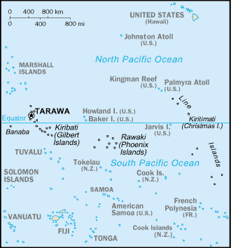
جزر خطُّ الاستواء Line Islands تتكون جزر خط الاستواء من 11 جزيرة مرجانية منخفضة معزولة، تقع في وسط المحيط الهادئ، على جانبي خط الاستواء، حيث تغطي مساحة 576كم². وتسمى أيضًا الجزر الاستوائية.

تسيطر الولايات المتحدة على ثلاث من تلك الجزر وهي: جارفس، وكنجمان ريف، وبالميرا. وتشكل الجزر الثماني الأخرى من مجموعة جزر خط الاستواء جزءًا من جزر كيريباتي، وهي جزر كارولين، وفلنت، وكريتيماتي (ويطلق عليها اسم جزيرة كريسماس أيضاً)، ومالدن وستاربَك، وتابيوران فانينج، وترينا (واشنطن)، وفوستوك. وتشمل جزر كيريباتي أيضًا بانابا، وجزر جيلبرت، وجزر فينيكس.

Atoll/الجزيرة/Reef Island المساحة
كم²
Lagoon
كم²
الإحداثيات Status

جزر خط الإستواء الشمالية (Fanning's Group)

Kingman Reef 0.03 60 6°24′N 162°24′W / 6.400°N 162.400°W / 6.400; -162.400 (Kingman Reef) U.S. unincorporated territory
Palmyra Atoll 6.56 15 5°52′N 162°6′W / 5.867°N 162.100°W / 5.867; -162.100 (Palmyra Atoll) U.S. incorporated territory
Teraina (Washington Island) 14.2 2* 4°43′N 160°24′W / 4.717°N 160.400°W / 4.717; -160.400 (Teraina) Kiribati Island Council
Tabuaeran (Fanning Island) 33.7 110 3°52′N 159°22′W / 3.867°N 159.367°W / 3.867; -159.367 (Tabuaeran) Kiribati Island Council
Kiritimati (Christmas Island) c.322 c.320 1°53′N 157°24′W / 1.883°N 157.400°W / 1.883; -157.400 (Kiritimati) Kiribati Island Council

جزر خط الإستواء الوسطى

Jarvis Island 4.45 - 0°22′S 160°03′W / 0.367°S 160.050°W / -0.367; -160.050 (Jarvis Island) U.S. unincorporated territory
Malden Island 39.3 13* 4°01′S 154°59′W / 4.017°S 154.983°W / -4.017; -154.983 (Malden Island) part of Kiribati
Filippo Reef - 1.5 5°30′S 151°50′W / 5.500°S 151.833°W / -5.500; -151.833 (Filippo Reef) outside EEZ
Starbuck Island 21 25 5°37′S 155°56′W / 5.617°S 155.933°W / -5.617; -155.933 (Starbuck Island) جزء من كيريباتي

جزر خط الإستواء الجنوبية

Caroline Island 3.76 2.5 9°57′S 150°13′W / 9.950°S 150.217°W / -9.950; -150.217 (Caroline Island) جزء من كيريباتي
Vostok Island 0.24 - 10°06′S 152°25′W / 10.100°S 152.417°W / -10.100; -152.417 (Vostok Island) جزء من كيريباتي
Flint Island 3 - 11°26′S 151°48′W / 11.433°S 151.800°W / -11.433; -151.800 (Flint Island) part of Kiribati
Line Islands 514,74 538

* The lagoon areas marked with an asterisk are contained within the island areas of the previous column because they are, unlike in the case of a typical atoll, inland waters completely sealed off from the sea.

Kr-map.png


. . . . . . . . . . . . . . . . . . . . . . . . . . . . . . . . . . . . . . . . . . . . . . . . . . . . . . . . . . . . . . . . . . . . . . . . . . . . . . . . . . . . . . . . . . . . . . . . . . . . . . . . . . . . . . . . . . . . . . . . . . . . . . . . . . . . . . . . . . . . . . . . . . . . . . . . . . . . . . . . . . . . . . . .

انظر أيضًا