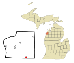
تومسونڤل، مشيگن
تومسونڤل، مشيگن Thompsonville, Michigan | |
|---|---|
 موقع تومسونڤل، مشيگن | |
| الإحداثيات: 44°31′13″N 85°56′30″W / 44.52028°N 85.94167°W | |
| البلد | الولايات المتحدة |
| الولاية | مشيگن |
| المقاطعة | بنزي |
| المساحة | |
| • الإجمالي | 2٫59 كم² (1٫00 ميل²) |
| • البر | 2٫59 كم² (1٫00 ميل²) |
| • الماء | 0 كم² (0 ميل²) |
| المنسوب | 242 m (794 ft) |
| التعداد | |
| • الإجمالي | 441 |
| • Estimate (2012[3]) | 438 |
| • الكثافة | 170٫3/km2 (441٫0/sq mi) |
| منطقة التوقيت | UTC-5 (Eastern (EST)) |
| • الصيف (التوقيت الصيفي) | UTC-4 (EDT) |
| ZIP code | 49683 |
| مفتاح الهاتف | 231 |
| FIPS code | 26-79600[4] |
| GNIS feature ID | 1614783[5] |
تومسونڤل Thompsonville هي بلدة في مقاطعة بنزي، مشيگن. وقت إحصاء سكان عام 2002، عدد السكان كان 457. البلدة تقع في جنوب المقاطعة على الحد بين بلدتي ولدون وكولفاكس.
الديمغرافيا
| ||||||||||||||||||||||||||||||||||||||||||||||||||||||||||||||||
المناخ
| Climate data for Thompsonville, Michigan | |||||||||||||
|---|---|---|---|---|---|---|---|---|---|---|---|---|---|
| Month | Jan | Feb | Mar | Apr | May | Jun | Jul | Aug | Sep | Oct | Nov | Dec | Year |
| Mean daily maximum °C (°F) | 22 (−6) |
24 (−4) |
34 (1) |
48 (9) |
62 (17) |
71 (22) |
77 (25) |
75 (24) |
66 (19) |
54 (12) |
39 (4) |
28 (−2) |
50 (10) |
| Mean daily minimum °C (°F) | 5 (−15) |
4 (−16) |
12 (−11) |
25 (−4) |
37 (3) |
44 (7) |
50 (10) |
49 (9) |
42 (6) |
33 (1) |
23 (−5) |
12 (−11) |
28 (−2) |
| Average precipitation mm (inches) | 3.5 (89) |
1.8 (46) |
2.2 (56) |
2.2 (56) |
2.8 (71) |
3.2 (81) |
3.2 (81) |
3.6 (91) |
3.8 (97) |
3.5 (89) |
3.0 (76) |
3.0 (76) |
35.8 (909) |
| Source: Weatherbase [8] | |||||||||||||
الهامش
- ^ خطأ استشهاد: وسم
<ref>غير صحيح؛ لا نص تم توفيره للمراجع المسماةGazetteer files - ^ خطأ استشهاد: وسم
<ref>غير صحيح؛ لا نص تم توفيره للمراجع المسماةFactFinder - ^ "Population Estimates". United States Census Bureau. Retrieved 2013-06-03.
- ^ "American FactFinder". United States Census Bureau. Retrieved 2008-01-31.
- ^ "US Board on Geographic Names". United States Geological Survey. 2007-10-25. Retrieved 2008-01-31.
- ^ "Annual Estimates of the Resident Population for Incorporated Places: April 1, 2010 to July 1, 2015". Retrieved July 2, 2016.
- ^ "Census of Population and Housing". Census.gov. Retrieved June 4, 2015.
- ^ "Weatherbase.com". Weatherbase. 2013. Retrieved on July 2, 2013.
الكلمات الدالة: