تشونن
Cheonan
천안시 | |
|---|---|
| الترجمة اللفظية بالـ Korean | |
| • Hangul | 천안시 |
| • Hanja | 天安市 |
| • Revised Romanization | Cheonan-si |
| • McCune-Reischauer | Ch'ŏnan-si |
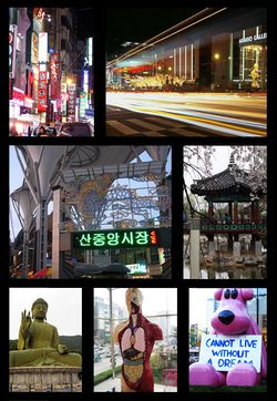
 Left to right: Shinbu lanes, Terminal, Namsan Public market, Samgeori Park, Taejeosan Bronze Buddha, Arario Gallery sculpture, Yawoori dream bear | |
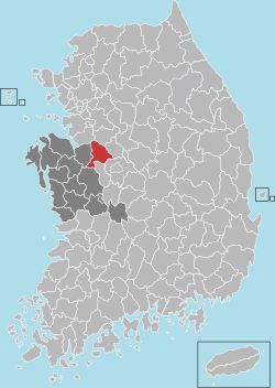
 Location in South Korea | |
| الإحداثيات: 36°49′00″N 127°10′00″E / 36.816667°N 127.166667°E | |
| Country | |
| Region | Hoseo |
| Administrative divisions | 2 gu, 16 legal dong, 4 eup, 8 myeon |
| المساحة | |
| • الإجمالي | 636٫25 كم² (245٫66 ميل²) |
| المنسوب | 22 m (72 ft) |
| التعداد (2011 Sep) | |
| • الإجمالي | 582٬753 |
| • الكثافة | 915٫9/km2 (2٬372/sq mi) |
| • Dialect | Chungcheong |
| الموقع الإلكتروني | www.cheonan.go.kr |
تشونـَن (Cheonan ؛ Cheonan-si، وأحياناً تُتهجى Chonan أو Ch'onan؛ النطق الكوري: [tɕʰʌ.nan] (![]() استمع)) هي مدينة تقع في الركن الشمالي الشرقي من مقاطعة South Chungcheong في كوريا الجنوبية، وتقع على بعد 83.6 كم جنوب العاصمة، سول.[1] The average temperature in the city is 12.5oC, with a recorded high of 34.2oC and a low of -13.4oC.[2]
استمع)) هي مدينة تقع في الركن الشمالي الشرقي من مقاطعة South Chungcheong في كوريا الجنوبية، وتقع على بعد 83.6 كم جنوب العاصمة، سول.[1] The average temperature in the city is 12.5oC, with a recorded high of 34.2oC and a low of -13.4oC.[2]
Cheonan has been called "the core city of [the] nation" [1] as it is the gateway to the area around the national capital region and western Chungcheong, as well as the main transportation hub for the national road (Hwy 1, 21), railways, and expressways (IC 1-Gyeongbu Expressway, 25-Honam Expressway). At the Korail station in the downtown center, the Gyeongbu Line crosses north to south, and the Janghang Line extends to the south-west. It is also part of Seoul Subway Line 1 and the KTX. [3] Land routes open in all directions, including north to Seoul, west to Asan, south to Gwangju and Daejeon, and east to Daegu and Busan.
الجغرافيا

المناخ
The climate of Cheonan is similar to that of neighboring Seoul, Suwon, or Daejeon, and is considered temperate Eastern margin with periods of monsoon. Cheonan experiences a four-season weather cycle, with moderately high summer temperatures and moderately low temperatures and snowfall in winter.
| Climate data for تشونن (1981–2010، القصوى 1971–الحاضر) | |||||||||||||
|---|---|---|---|---|---|---|---|---|---|---|---|---|---|
| Month | Jan | Feb | Mar | Apr | May | Jun | Jul | Aug | Sep | Oct | Nov | Dec | Year |
| Record high °C (°F) | 16.5 (61.7) |
20.6 (69.1) |
26.7 (80.1) |
31.2 (88.2) |
33.9 (93.0) |
34.8 (94.6) |
37.7 (99.9) |
36.7 (98.1) |
33.9 (93.0) |
28.4 (83.1) |
25.3 (77.5) |
18.2 (64.8) |
37.7 (99.9) |
| Mean daily maximum °C (°F) | 2.5 (36.5) |
5.3 (41.5) |
11.2 (52.2) |
18.6 (65.5) |
23.7 (74.7) |
27.2 (81.0) |
29.4 (84.9) |
30.1 (86.2) |
26.0 (78.8) |
20.3 (68.5) |
12.5 (54.5) |
5.4 (41.7) |
17.7 (63.9) |
| Daily mean °C (°F) | −2.9 (26.8) |
−0.4 (31.3) |
4.8 (40.6) |
11.5 (52.7) |
17.2 (63.0) |
21.5 (70.7) |
24.7 (76.5) |
25.1 (77.2) |
20.0 (68.0) |
13.3 (55.9) |
6.2 (43.2) |
−0.1 (31.8) |
11.8 (53.2) |
| Mean daily minimum °C (°F) | −7.9 (17.8) |
−5.6 (21.9) |
−1.0 (30.2) |
4.7 (40.5) |
11.2 (52.2) |
16.5 (61.7) |
20.9 (69.6) |
21.0 (69.8) |
15.0 (59.0) |
7.2 (45.0) |
0.8 (33.4) |
−4.9 (23.2) |
6.5 (43.7) |
| Record low °C (°F) | −23.9 (−11.0) |
−19.9 (−3.8) |
−10.4 (13.3) |
−5.2 (22.6) |
2.0 (35.6) |
6.9 (44.4) |
12.5 (54.5) |
12.1 (53.8) |
3.0 (37.4) |
−4.3 (24.3) |
−10.4 (13.3) |
−18.7 (−1.7) |
−23.9 (−11.0) |
| Average precipitation mm (inches) | 23.4 (0.92) |
26.4 (1.04) |
45.9 (1.81) |
61.4 (2.42) |
85.7 (3.37) |
133.1 (5.24) |
264.7 (10.42) |
298.3 (11.74) |
158.4 (6.24) |
53.1 (2.09) |
49.2 (1.94) |
26.8 (1.06) |
1٬226٫5 (48.29) |
| Average precipitation days (≥ 0.1 mm) | 8.3 | 6.7 | 7.9 | 7.6 | 7.7 | 8.6 | 13.9 | 13.6 | 8.6 | 6.2 | 8.7 | 9.5 | 107.3 |
| Average snowy days | 8.7 | 5.3 | 2.1 | 0.1 | 0.0 | 0.0 | 0.0 | 0.0 | 0.0 | 0.1 | 2.4 | 7.2 | 25.9 |
| Average relative humidity (%) | 72.1 | 68.3 | 65.7 | 62.1 | 65.9 | 72.4 | 79.4 | 78.7 | 76.5 | 73.0 | 73.2 | 72.8 | 71.7 |
| Mean monthly sunshine hours | 171.5 | 183.6 | 216.7 | 233.3 | 249.3 | 221.6 | 184.2 | 206.9 | 198.7 | 214.7 | 164.0 | 160.3 | 2٬412٫7 |
| Percent possible sunshine | 55.6 | 60.0 | 58.5 | 59.2 | 56.9 | 50.4 | 41.3 | 49.3 | 53.3 | 61.5 | 53.4 | 53.3 | 54.2 |
| Source: Korea Meteorological Administration[4][5][6] (percent sunshine and snowy days)[7] | |||||||||||||
الرموز
- شجرة المدينة: Weeping willow
- زهرة المدينة: Golden bell flower
- طائر المدينة: الحمامة
- حيوان المدينة: التنين
المدن الشقيقة
 بيڤرتون، أوريگون، الولايات المتحدة[8] منذ 1 مايو 1989
 شيجیاژوانگ، خىبـِيْ، الصين
المدن الصديقة
 بويوك چكمجه, اسطنبول، تركيا
 وندنگ، شاندونگ، الصين
انظر أيضاً
- قائمة المدن في كوريا الجنوبية
- جغرافيا كوريا الجنوبية
- Stele of Bongseon Honggyeongsa, a National Treasure located in Cheonan
الهامش
- ^ أ ب "General Information - Cheonan". City of Cheonan. Retrieved 4 February 2015.
- ^ http://stat.cheonan.go.kr/contents/cheonan_graph/index.asp?MenuMod=12[dead link]
- ^ http://info.korail.com/2007/eng/eng_index.jsp
- ^ "평년값(30년 평균) 자료 천안(232)" (in Korean). Korea Meteorological Administration. Retrieved May 24, 2011.
{{cite web}}: CS1 maint: unrecognized language (link) - ^ "기후자료극값(최대값) 7월 일최고기온 (℃) 최고순위 천안(232)" (in Korean). Korea Meteorological Administration. Retrieved February 20, 2017.
{{cite web}}: CS1 maint: unrecognized language (link) - ^ "기후자료극값(최대값) 1월 일최저기온 (℃) 최저순위 천안(232)" (in Korean). Korea Meteorological Administration. Retrieved February 20, 2017.
{{cite web}}: CS1 maint: unrecognized language (link) - ^ "Climatological Normals of Korea" (PDF). Korea Meteorological Administration. 2011. p. 499 and 649. Archived from the original (PDF) on 7 December 2016. Retrieved 20 February 2017.
- ^ Beaverton Sister Cities Foundation - Cheonan, Korea Archived يوليو 20, 2008 at the Wayback Machine
وصلات خارجية
 Cheonan travel guide from Wikivoyage
- City government website
- Cheonan resident-foreigner blog
