چانگآن
| تشانغآن | |||||||||||||||||||||||
|---|---|---|---|---|---|---|---|---|---|---|---|---|---|---|---|---|---|---|---|---|---|---|---|
| الصينية المبسطة | 长安 | ||||||||||||||||||||||
| الصينية التقليدية | 長安 | ||||||||||||||||||||||
| المعنى الحرفي | "السلام الدائم" | ||||||||||||||||||||||
| |||||||||||||||||||||||

چانگآن ([tʂʰɑ̌ŋ.án] (![]() استمع)؛ الصينية المبسطة: 长安; الصينية التقليدية: 長安؛ إنگليزية: Chang'an) هي عاصمة قديمة لأكثر من عشر أسر في التاريخ الصيني، وتُعرف الآن بإسم شيآن. چانگآن تعني "السلام الدائم" في الصينية الكلاسيكية. أثناء أسرة شين قصيرة العمر، ثم تغير اسم المدينة إلى "السلام الثابت" (الصينية: 常安; پنين: Cháng'ān)؛ ولكن بعد سقوطها في عام 23م، استعيد الاسم القديم. وبحلول عهد أسرة مينگ، تغير الاسم مرة أخرى إلى شيآن، وتعني "السلام الغربي"، واستمر هذا الاسم حتى اليوم.
استمع)؛ الصينية المبسطة: 长安; الصينية التقليدية: 長安؛ إنگليزية: Chang'an) هي عاصمة قديمة لأكثر من عشر أسر في التاريخ الصيني، وتُعرف الآن بإسم شيآن. چانگآن تعني "السلام الدائم" في الصينية الكلاسيكية. أثناء أسرة شين قصيرة العمر، ثم تغير اسم المدينة إلى "السلام الثابت" (الصينية: 常安; پنين: Cháng'ān)؛ ولكن بعد سقوطها في عام 23م، استعيد الاسم القديم. وبحلول عهد أسرة مينگ، تغير الاسم مرة أخرى إلى شيآن، وتعني "السلام الغربي"، واستمر هذا الاسم حتى اليوم.
چانگآن had been settled since the Neolithic times, during which the Yangshao Culture established in Banpo in the city's suburb. Also in the northern vicinity of the modern Xi'an, the tumulus ruler Qin Shi Huang of Qin dynasty held his imperial court, and constructed his massive mausoleum guarded by the famed Terracotta Army.
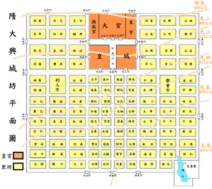
From its capital at Xianyang, the Qin dynasty ruled a larger area than either of the preceding dynasties. The imperial city of Chang'an during the Han dynasty was located in northwest of today's Xi'an. During the Tang dynasty, the area to be known as Chang'an included the area inside the Ming Xi'an fortification, plus some small areas to its east and west, and a major part of its southern suburbs. The Tang Chang'an hence, was 8 times the size of the Ming Xi'an, which was reconstructed upon the premise of the former imperial quarter of the Sui and Tang city. During its heyday, Chang'an was one of the largest and most populous cities in the world. Around AD 750, Chang'an was called a "million people's city" in Chinese records, while modern estimates put it at around 800,000–1,000,000 within city walls.[1][2] According to the census in 742 recorded in the New Book of Tang, 362,921 families with 1,960,188 persons were counted in Jingzhao Fu (京兆府), the metropolitan area including small cities in the vicinity.[3]
فترات سوي و تانگ
تقسيم المدينة
البرك والغدائر والقنوات

جنوب وسط چانگآن
غرب وسط چانگآن
شرق وسط چانگآن

القصر الغربي

انظر أيضاً
- Ancient Chinese urban planning
- العواصم التاريخية للصين
- List of cities in China
- Silk Road transmission of Buddhism
- Xi Ming Temple
- شيآن
- تاريخ شيآن
مراجع
الهامش
- ^ (a) Tertius Chandler, Four Thousand Years of Urban Growth: An Historical Census, Lewiston, New York: The Edwin Mellen Press, 1987. ISBN 0-88946-207-0. (b) George Modelski, World Cities: –3000 to 2000, Washington, D.C.: FAROS 2000, 2003. ISBN 0-9676230-1-4.
- ^ Haywood, John; Jotischky, Andrew; McGlynn, Sean (1998). Historical Atlas of the Medieval World, AD 600-1492. Barnes & Noble. pp. 3.20, 3.31. ISBN 978-0-7607-1976-3.
- ^ New Book of Tang, vol. 41 (Zhi vol. 27) Geography 1.
ببليوگرافيا
| هذه المقالة تحتوي على نصوص بالصينية. بدون دعم الإظهار المناسب, فقد ترى علامات استفهام ومربعات أو رموز أخرى بدلاً من الحروف الصينية. |
- Benn, Charles (2002). China's Golden Age: Everyday Life in the Tang Dynasty. Oxford: Oxford University Press. ISBN 0-19-517665-0.
- Ebrey, Walthall, Palais (2006). East Asia: A Cultural, Social, and Political History. Boston: Houghton Mifflin Company. ISBN 0-618-13384-4.
- Needham, Joseph (1986). Science and Civilization in China: Volume 4, Physics and Physical Technology, Part 2, Mechanical Engineering. Taipei: Caves Books Ltd.
- Ma, Dezhi. "Sui Daxing Tang Chang’an Cheng Yizhi" ("Archeological Site of Sui's Daxing and Tang's Chang'an". Encyclopedia of China (Archeology Edition), 1st ed.
- Rockhill (1899): The Land of the Lamas: Notes of a Journey Through China, Mongolia and Tibet. William Woodville Rockhill. Longmans, Green and Co., London. Reprint: Winsome Books, Delhi, 2005. ISBN 81-88043-34-6.
- Xue, Pingshuan. 五代宋元时期古都长安商业的兴衰演变.
- Wang, Chongshu. "Han Chang’an Cheng Yizhi" ("Archeological Site of Han's Chang'an"). Encyclopedia of China (Archeology Edition), 1st ed.
- cultural-china.com (2007), Excavation of Changan, http://history.cultural-china.com/en/183H6233H12083.html, retrieved on 2009
- China Features (November 19, 2006), Archaeologists dig deep to revive 2,200 year-old ancient capital, http://en.0437.gov.cn/dispArticle.Asp?ID=895, retrieved on 2009
- Ministry of Culture, P.R.Chin (2003), Site of Capital Chang'an of Hanl, http://www.chinaculture.org/gb/en_travel/2003-09/24/content_36839.htm, retrieved on 2009
- Schinz, Alfred (1996). The magic square: cities in ancient China. Edition Axel Menges. p. 428. ISBN 3-930698-02-1.
{{cite book}}: Cite has empty unknown parameter:|coauthors=(help) - Institute of Archaeology, Chinese Academy of Social Sciences (IA CASS) (2003), Underground Passages Reveal Power Struggle in Ancient Han Capital, http://www.kaogu.cn/en/detail.asp?ProductID=957, retrieved on 2009
للاستزادة
- Cotterell, Arthur (2007). "The Imperial Capitals of China - An Inside View of the Celestial Empire." Pimlico. ISBN 978-1-84595-009-5. 304 pages.
- Schafer, Edward H. "The Last Years of Ch’ang’an". Oriens Extremus X (1963):133-179.
- Sirén, O. "Tch’angngan au temps des Souei et des T’ang". Revue des Arts Asiatiques 4 (1927):46-104.
- Steinhardt, Nancy Shatzman (1999). Chinese Imperial City Planning. Honolulu: University of Hawaii Press.
- Xiong, Victor Cunrui (2000). Sui-Tang Chang’an: A Study in the Urban History of Medieval China. Ann Arbor: University of Michigan Center for Chinese Studies.
وصلات خارجية
| سبقه شيانيانگ |
عاصمة الصين 206 ق.م.-25 م |
تبعه لوويانگ |
- Pages using gadget WikiMiniAtlas
- Articles with hatnote templates targeting a nonexistent page
- Missing redirects
- Articles containing صينية-language text
- Transliteration template errors
- Articles containing simplified Chinese-language text
- Articles containing traditional Chinese-language text
- Articles containing إنگليزية-language text
- Pages using Lang-xx templates
- Articles containing Chinese-language text
- Coordinates on Wikidata
- Ancient Chinese capitals
- History of Xi'an
- أماكن مأهولة على طريق الحرير
- مواقع على طريق الحرير


