بكنگهامشاير
(تم التحويل من بكنگهامشاير)
بكنگهامشاير Buckinghamshire | |||||||||||||||||||||||||||||||||||||||||||||||||||||
|---|---|---|---|---|---|---|---|---|---|---|---|---|---|---|---|---|---|---|---|---|---|---|---|---|---|---|---|---|---|---|---|---|---|---|---|---|---|---|---|---|---|---|---|---|---|---|---|---|---|---|---|---|---|
| الشعار: Vestigia nulla retorsum ("No turning back/We do not retreat") | |||||||||||||||||||||||||||||||||||||||||||||||||||||
 | |||||||||||||||||||||||||||||||||||||||||||||||||||||
| الإحداثيات: 51°50′N 0°50′W / 51.833°N 0.833°W | |||||||||||||||||||||||||||||||||||||||||||||||||||||
| البلد | المملكة المتحدة | ||||||||||||||||||||||||||||||||||||||||||||||||||||
| المقاطعة | إنگلترة | ||||||||||||||||||||||||||||||||||||||||||||||||||||
| المنطقة | جنوب شرق إنگلترة | ||||||||||||||||||||||||||||||||||||||||||||||||||||
| التأسيس | Ancient | ||||||||||||||||||||||||||||||||||||||||||||||||||||
| منطقة التوقيت | UTC±00:00 (توقيت گرينتش المتوسط) | ||||||||||||||||||||||||||||||||||||||||||||||||||||
| • الصيف (التوقيت الصيفي) | UTC+01:00 (توقيت بريطانيا الصيفي) | ||||||||||||||||||||||||||||||||||||||||||||||||||||
| أعضاء البرلمان | List of MPs | ||||||||||||||||||||||||||||||||||||||||||||||||||||
| الشرطة | Thames Valley Police | ||||||||||||||||||||||||||||||||||||||||||||||||||||
| |||||||||||||||||||||||||||||||||||||||||||||||||||||
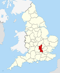
بكنگهامشاير (Buckinghamshire ؛ /ˈbʌkɪŋəmʃər/ أو /ˈbʌkɪŋəmʃɪər/, abbreviated Bucks; archaically the County of Buckingham) هي ceremonial county في جنوب شرق إنگلترة. ويحدها لندن الكبرى إلى الجنوب الشرقي، وبركشاير to the south, Oxfordshire to the west, Northamptonshire إلى الشمال، Bedfordshire إلى الشمال الشرقي و Hertfordshireإلى الشرق.
السكان
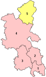
| District | البلدات الرئيسية | Population (2011)[1] | المساحة | الكثافة السكانية (2011) | التعداد المتوقع 2026 |
| Aylesbury Vale | Aylesbury, بكنگهام | 174,137 | 902.75 كم² | 193/كم² | 213,000 |
| Wycombe | High Wycombe, Marlow | 171,644 | 324.57 كم² | 529/km² | 255,000 |
| Chiltern | Amersham, Chesham | 92,635 | 196.35 km² | 472/km² | 89,000 |
| South Bucks | Beaconsfield, Burnham | 66,867 | 141.28 km² | 474/km² | 63,800 |
| TOTAL Non-Metropolitan | N/A | 505,283 | 1565 km² | 323/km² | 530,800 |
| Borough of Milton Keynes | Milton Keynes, Newport Pagnell | 248,821 | 308.63 km² | 806/km² | 323,146[2] |
| TOTAL Ceremonial | N/A | 754,104 | 1874 km² | 402/km² | 853,946 |
انظر أيضاً
- Lord Lieutenant of Buckinghamshire
- High Sheriff of Buckinghamshire
- Architecture of Aylesbury
- Bucks County, Pennsylvania
- Wendover Woods
- Centre for Buckinghamshire Studies—Archives, Record Office, Local History and Family History
- Safety Centre
الهامش
وصلات خارجية
- Buckinghamshire County Council
- Buckinghamshire County Museum and Roald Dahl Children's Gallery
- Buckinghamshire Libraries
- Buckinghamshire Tourist Guide
- Bucks County and District Councils Portal
- Photographic Archive of Buckinghamshire
- Images of Buckinghamshire at the English Heritage Archive
- Commuter Towns in Buckinghamshire

|
Bedfordshire | Northamptonshire | Northamptonshire | 
|
| Bedfordshire Hertfordshire |
Oxfordshire | |||
| Greater London | Berkshire | Oxfordshire |
الكلمات الدالة:


