برزخ تهوانتپك

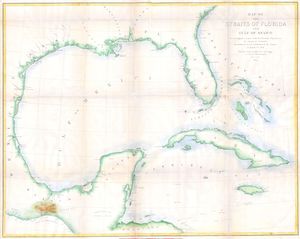
برزخ تهوانتپك (إنگليزية: Isthmus of Tehuantepec؛ النطق الإسپاني: [tewanteˈpek]) هو يرزخ في المكسيك. ويمثل أقصر مسافة بين خليج المكسيك والمحيط الهادي. وقبل افتتاح قناة پنما، فقد كانت طريق شحن رئيسي بُعرف ببساطة بإسم طريق تهوانتپك Tehuantepec Route. الاسم مأخوذ من بلدة سانتو دومنگو تهوانتپك in the state of Oaxaca؛ وتلك مشتقة من تعبير بلغة ناهواتل هو تكواني-تپك ("ربوة الفهود").
. . . . . . . . . . . . . . . . . . . . . . . . . . . . . . . . . . . . . . . . . . . . . . . . . . . . . . . . . . . . . . . . . . . . . . . . . . . . . . . . . . . . . . . . . . . . . . . . . . . . . . . . . . . . . . . . . . . . . . . . . . . . . . . . . . . . . . . . . . . . . . . . . . . . . . . . . . . . . . . . . . . . . . . .
الجغرافيا
يضم البرزخ جزء من المكسيك يقع بين خطي الطول 94 و 96 غرب، أو الأجزءا الجنوبية الشرقية من ڤراكروز و واخاكا، بما في ذلك أجزاء صغيرة من تشياپاس وتاباسكو. ولايات تاباسكو وتشياپاس يقعان شرق البرزخ، بينما ڤراكروز وواخاكا يقعان غربه.[1]
طريق تهوانتپك
منذ أيام هرنان كورتيز، كان برزخ تهوانتپك يُعتبر طريقاً مفضلاً، في البداية لقناة بين المحيطين، ومنذ القرن التاسع عشر لسكة حديدية بين المحيطين.[2] قربه من محور التجارة العالمية أعطاه بعض المزايا على طريق پنما. إلا أن برزخ پنما هو أضيق كثيراً، مما يجعله أقصر سفراً، حتى ولو أن القناة أبعد عن طرق التجارة.
معاهدة شراء گادسدن في 1853[3] تضمنت بنداً يسمح للولايات المتحدة أن تنقل البريد والسلع التجارية عبر برزخ تهوانتپك عبر plank road و سكة حديدية.[4] معاهدة مكلين-أوكامپو في 1859، التي وقـَّعها بنيتو خواريز إلا أن الكونگرس الأمريكي لم يصدق عليها أبداً، كانت ستعطي الولايات المتحدة حقوق العبور (الترانزيت) على نفس الطريق.
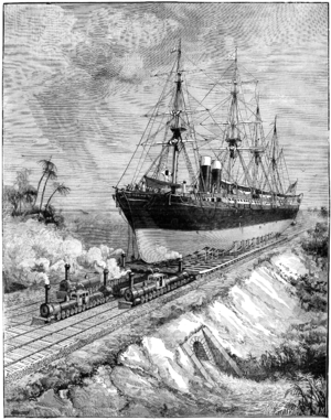
وحين أجبرت التكلفة الباهظة لإنشاء القناة المهندسين ورؤوس الأموال على التخلي عن عنها لكونها غير عملية، فإن جيمس إيدز James B. Eads اقترح إنشاء ship-railway رباعي السكك، وحظي المخطط بانتباه جاد لبعض الوقت.[5] ثم جاءت مشاريع لسكة حديدية عادية، ومنحت الحكومة المكسيكية العديد من الامتيازات لهذا الغرض من 1857 حتى 1882. وفي السنة الأخيرة، قررت الحكومة المكسيكية القيام بإنشاء سكة حديدية على نفقتها، ووقعت عقوداً مع مقاول مكسيكي بارز للقيام بالعمل. وفي 1888 تم فض العقد، بعد إكتمال 108 كيلومتر من الطريق.[6]
العقد التالي كان غير مجدٍ بسبب وفاة المقاول، والثالث فشل في إنهاء العمل ضمن الثمن المحدد (GB£2,700,000).[1] This was in 1893, and 60 km (37 mi) remained to be built. A fourth contract resulted in the completion of the 130-mile line from coast to coast in 1894.[7] But, it was found that the terminal ports were deficient in facilities and the railroad was too light for heavy traffic.[8]
The government then entered into a contract with the London firm of contractors of S. Pearson & Son, Ltd., who had constructed the drainage works of the valley of Mexico and the new port works of Veracruz, to rebuild the line and construct terminal ports في Coatzacoalcos على ساحل الخليج, and at سالينا كروز على جانب الهادي. The work was done for account of the Mexican government. Work began on 10 December 1899, and was finished to a point where its formal opening for traffic was possible in January 1907.[8]
السكة الحديدية يبلغ طولها 308 كيلومتر، بفرع طوله 29 كم بين خويلى وسان خوان إڤانگليستا. أقل عمق في الجـَزر في المينائين هو 10 متر. An extensive system of quays and railway tracks at both terminals affords ample facilities for the expeditious handling of heavy cargoes. The general offices and repair shops of the original Tehuantepec Railway were located at Rincón Antonio, at the entrance to the Chivela Pass. At Santa Lucrecia, 175 km (109 mi) from Salina Cruz, connection was made with the Veracruz & Pacific Railway, 343 km (213 mi) to Córdoba, Veracruz, and 500 km (310 mi) to Mexico City. Those connecting lines are now owned and operated by Ferrosur, a company that also operates along the Ferroistmo-owned Tuehantepec line.
انظر أيضاً
- شركة البواخر الأمريكية-الهاوائية
- Ferrocarril de Veracruz al Istmo
- إستمو دى تهوانتپك، واخاكا
- برزخ پنما هو موقع قناة پنما
- Mexican Federal Highway 185
- قناة نيكاراگوا
الهامش
- ^ أ ب
 Chisholm, Hugh, ed. (1911). "Tehuantepec". دائرة المعارف البريطانية. Vol. 26 (eleventh ed.). Cambridge University Press. p. 507.
 {{cite encyclopedia}}: Cite has empty unknown parameter:|coauthors=(help) - ^ Fred Wilbur Powell, The Railroads of Mexico; Stratford Co., Boston, Mass., 1921. p. 149.
- ^ "Gadsden Purchase Treaty : December 30, 1853", The Avalon Project
- ^ See "Tehuantepec Railroad--Sloo's Grant"; The New York Times, May 5, 1853, p. 4.
- ^ John H. Lienhard, "An Un-Panama Canal", Engines of Our Ingenuity No. 1777, citing J. E. Vollmar, Jr., "The Most Gigantic Railroad". Invention and Technology, Vol. 18, No. 4, Spring 2003, pg. 64.
- ^ U.K. Foreign Office, Mexico; Report on the Mexican Isthmus (Tehuantepec) Railway No. 658, Miscellaneous Series, Diplomatic and Consular Reports; April, 1907.
- ^ "The Tehuantepec Railroad; An Important Mexican Enterprise Completed"; The New York Times, November 22, 1894, p. 12.
- ^ أ ب Report on the Mexican Isthmus (Tehuantepec) Railway, p. 5.
وصلات خارجية
- The Tehuantepec Ship-Railway
- The Mexican Railways, with information on the current owners (concessions) of Mexican railways.
- Beach, Chandler B., ed. (1914). . . Chicago: F. E. Compton and Co.
- مقالات المعرفة المحتوية على معلومات من دائرة المعارف البريطانية طبعة 1911
- Pages using gadget WikiMiniAtlas
- Articles containing إنگليزية-language text
- Pages using Lang-xx templates
- Pages with empty portal template
- Wikipedia articles incorporating citation to the NSRW
- Wikipedia articles incorporating citation to the NSRW with an wstitle parameter
- Coordinates on Wikidata
- برازخ أمريكا الشمالية
- تضاريس المكسيك
- مناطق المكسيك
- جنوب المكسيك
- جغرافيا وسط أمريكا
- Landforms of Campeche
- Landforms of Oaxaca
- Landforms of Tabasco
- Landforms of Veracruz
- Sierra Madre de Chiapas
- Sierra Madre de Oaxaca
- Sierra Madre del Sur
- Portages
- قنوات مقترحة
- طرق تجارية


