المنطقة غير المشبعة بالماء


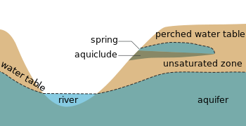
المنطقة غير المشبعة بالماء أو منطقة ڤادوز Vadose zone ، لهذه الطبقة أهمية كبيرة لعملية تغذية المياه الجوفية ، وتنقسم هذه الطبقة إلى ثلاث طبقات فرعية هي :
1-التربة (Soil Zone) : هي طبقة تمتد من سطح الأرض إلى عمق متر أو اثنين وهى طبقة تساعد في عملية نمو النباتات ، وتنمو بها الجذور وتحتوي على فراغات نتيجة تحلل الجور الميتة بالإضافة إلى احتوائها على الديدان والحيوانات. المسامية والنفاذية في هذه التربة أعلى من الطبقات الموجودة تحتها، والمياه في هذه المنطقة تتحرك إلى الأسفل نتيجة الترشيح أو إلى الأعلى نتيجة التبخر. بشكل مؤقت ونتيجة لعملية ترشيح كبيرة يمكن أن تمتلئ هذه المنقطة بالمياه تماما.
2-المنطقة المتوسطة (Intermediate Zone) : يختلف سمك هذه الطبقة من منطقة إلى أخرى اعتمادا على سمك طبقة التربة بالإضافة إلى العمق إلى منطقة الشعيرات المائية (Capillary Fringe) حيث يمكن أن يمتد سمكها من صفر إلى عشرات الأمتار اعتمادا على عمق المياه الجوفية. بشكل مؤقت المياه الداخلة تتحرك إلى الأسفل نتيجة الجاذبية.
3- منطقة الشعيرات المائية (Capillary fringe) : هي الطبقة التي تحتوي على تربة ذات خاصية شعرية وهى الطبقة السفلي من المنطقة غير المشبعة بالماء وتحدث نتيجة التجاذب بين الماء والصخور، حيث تتعلق جزيئات الماء كشريط على حبيبات التربة وترتفع في الفراغات ذات القطر الصغير في اتجاه معاكس للجاذبية الأرضية. تقع هذه الطبقة تحت ضغط سالب اقل من الضغط الجوي ، وتعتبر هذه الطبقة مشبعة بالماء.
. . . . . . . . . . . . . . . . . . . . . . . . . . . . . . . . . . . . . . . . . . . . . . . . . . . . . . . . . . . . . . . . . . . . . . . . . . . . . . . . . . . . . . . . . . . . . . . . . . . . . . . . . . . . . . . . . . . . . . . . . . . . . . . . . . . . . . . . . . . . . . . . . . . . . . . . . . . . . . . . . . . . . . . .
في الهيدرولوجيا

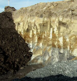
The vadose zone is the undersaturated portion of the subsurface that lies above the groundwater table. The soil and rock in the vadose zone are not fully saturated with water; that is, the pores within them contain air as well as water. The portion of the vadose zone that is inhabited by soil microorganism, fungi and plant roots may sometimes be called the soil carbon sponge.
In some places, the vadose zone is absent, as is common where there are lakes and marshes, and in some places, it is hundreds of meters thick, as is common in arid regions.[1]
Unlike the aquifers of the underlying water-saturated phreatic zone, the vadose zone is not a source of readily available water for human consumption. It is of great importance in providing water and nutrients that are vital to the soil carbon sponge and the biosphere. It is intensively used for the cultivation of plants, construction of buildings, and disposal of waste.[1]
The vadose zone is often the main factor controlling water movement from the land surface to the aquifer. Thus, it strongly affects the rate of aquifer recharge and is critical for the use and management of groundwater. Flow rates and chemical reactions in the vadose zone also control whether, where, and how fast contaminants enter groundwater supplies. Understanding of vadose-zone processes is therefore crucial in determining the amount and quality of groundwater that is available for human use.[1]
في علم المغارات

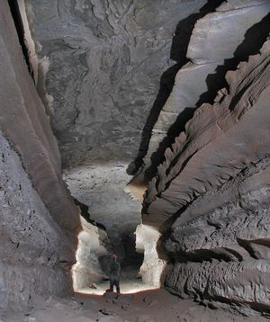
In speleology, cave passages formed in the vadose zone tend to be canyon-like in shape, as the water dissolves bedrock on the floor of the passage.[2] Passages created in completely water-filled conditions are called phreatic passages and tend to be circular in cross-section.[3]
انظر أيضاً
- Aquifer
- Capillary fringe
- Epiphreatic zone
- Groundwater
- Infiltration (hydrology)
- Phreatic zone
- Water retention curve
المراجع
للاستزادة
- "Unsaturated Zone". USGS. Retrieved 2014-05-01.
- "Aquifers". USGS. Retrieved 2014-05-01.
- "Unsaturated Zone Definitions Page". USGS. Retrieved 2006-07-01.
- "Unsaturated Zone Flow: Definitions and Details". USGS. Archived from the original on 2006-05-24. Retrieved 2006-07-01.
- Wilson, L.G.; Everett, Lorne G.; Cullen, Stephen J., eds. (1994). Handbook of Vadose Zone Characterization & Monitoring. CRC Press. ISBN 0873716108.
