وسط إيطاليا
Central Italy
Italia centrale | |
|---|---|
 | |
| Country | Italy |
| Regions | |
| المساحة | |
| • الإجمالي | 58٬052 كم² (22٬414 ميل²) |
| التعداد | |
| • Estimate (2016 est.) | 12٬067٬524 |
| Languages | |
| – Official language | Italian |
| – Other common languages | |
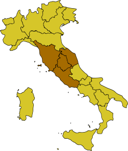
Central Italy (إيطالية: Italia centrale or just Centro) is one of the five official statistical regions of Italy used by the National Institute of Statistics (ISTAT), a first-level NUTS region, and a European Parliament constituency.
السكان
The resident population in central Italy amounts to 11,693,240 inhabitants.
المناطق
| Regione | Capoluogo | Abitanti[2] |
|---|---|---|
| قالب:IT-LAZ | 5٬707٬112 | |
| قالب:IT-MAR | 1٬480٬839 | |
| قالب:IT-TOS | 3٬651٬152 | |
| قالب:IT-UMB | 854٬137 |
The southernmost and easternmost parts of Lazio (Sora, Cassino, Gaeta, Cittaducale, Formia, and Amatrice districts) are often included in Southern Italy (the so-called Mezzogiorno) for cultural and historical reasons, since they were once part of the Kingdom of the Two Sicilies and southern Italian dialects are spoken.
As a geographical region, however, central Italy may also include the regions of Abruzzo and Molise,[3][4][5] which are otherwise considered part of Southern Italy for socio-cultural, linguistic and historical reasons.
أكبر البلديات تعداداً
Below is the list of the population residing in municipalities with more than 50,000 inhabitants.
المقاطعات
Politics
Marches, Tuscany, and Umbria, together with Emilia-Romagna, are considered to be the most left-leaning regions in Italy, and together are also referred to as the "Red Belt".[6][7][8][9] Lazio, except for Rome, is more politically conservative, a trait which it shares with both Northern and Southern Italy.[بحاجة لمصدر]
Economy
The gross domestic product (GDP) of the region was 380.9 billion euros in 2018, accounting for 21.6% of Italy's economic output. The GDP per capita adjusted for purchasing power was 31,500 euros, or 105% of the EU27 average the same year.[10]
See also
References
- ^ "Statistiche demografiche ISTAT". www.demo.istat.it. Archived from the original on 2017-11-27. Retrieved 2017-09-14.
- ^ أ ب خطأ استشهاد: وسم
<ref>غير صحيح؛ لا نص تم توفيره للمراجع المسماةabitanti - ^ Source: Touring Club Italiano (TCI), "Atlante stradale d'Italia". 1999–2000 TCI Atlas. ISBN 88-365-1115-5 (Northern Italy volume) – ISBN 88-365-1116-3 (Central Italy volume) – ISBN 88-365-1117-1 (Southern Italy volume)
- ^ Source: De Agostini, "Atlante Geografico Metodico". ISBN 88-415-6753-8
- ^ Source: Enciclopedia Italiana "Treccani"
- ^ "'Italians first': how the populist right became Italy's dominant force". The Guardian. 1 December 2018.
- ^ Roy Palmer Domenico (2002). The Regions of Italy: A Reference Guide to History and Culture. p. 313. ISBN 9780313307331.
- ^ "Italy's EU election results by region: Who won where?". The Local. 27 May 2019.
- ^ Publications, Europa Europa (2002). Western Europe 2003. p. 362. ISBN 9781857431520.
- ^ "Regional GDP per capita ranged from 30% to 263% of the EU average in 2018". Eurostat.
- Pages using gadget WikiMiniAtlas
- Short description is different from Wikidata
- Pages using infobox settlement with no coordinates
- Articles containing إيطالية-language text
- Pages using Lang-xx templates
- Articles with unsourced statements from October 2019
- Coordinates on Wikidata
- Geography of Italy
- أقاليم التصنيف الأول في الاتحاد الأوروپي


