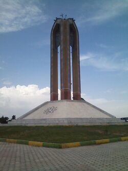
إسلام شهر
Eslamshahr
فارسية: اسلامشهر | |
|---|---|
City | |
 | |
| الإحداثيات: 35°32′19″N 51°13′22″E / 35.53861°N 51.22278°E[1] | |
| Country | Iran |
| Province | Tehran |
| County | Eslamshahr |
| District | Central |
| التعداد (2016)[2] | |
| • الإجمالي | 448٬129 |
| منطقة التوقيت | UTC+3:30 (IRST) |
| الموقع الإلكتروني | www |
Eslamshahr (فارسية: اسلامشهر)[أ] is a city in the Central District of Eslamshahr County, Tehran province, Iran, serving as capital of both the county and the district.[4]
Etymology
The name of Eslamshahr before the Islamic revolution in Iran was "Shadshahr" and in 1979 the government changed it to "Eslamshahr." The old historic name of Bahramabad is now applied only to the small northern suburbs of Eslamshahr, or the village of Bahramabad.
Demographics
Population
At the time of the 2006 National Census, the city's population was 357,171 in 91,293 households.[5] The following census in 2011 counted 389,102 people in 112,487 households.[6] The 2016 census measured the population of the city as 448,129 people in 137,638 households.[2]
The city has grown to be the most populous non-provincial capital city and the 19th overall most populous city of the country.[بحاجة لمصدر]
Geography
The city is located on the Saveh Road, which starts in the south of Tehran, and ends at Saveh City. Its neighborhoods are Vavan, Ghaemieh, Saeedieh, Mohamadieh, Mahdieh, Baghenarde, Saloor, Noori, Ghasemabad, Shirudi, Golha, Elahiye, Ahmadabad, Ghods, Baghqfeiz, Zarafshan, Moosiabad, Anbia and Mianabad.
Climate
Eslamshahr has a cold semi-arid climate (Köppen BSk). The highest recorded temperature was 43 °C (109 °F), recorded on July 10, 1990, while the lowest recorded temperature was −13 °C (9 °F), recorded on January 2, 1973.[7]
| أخفClimate data for Eslamshahr | |||||||||||||
|---|---|---|---|---|---|---|---|---|---|---|---|---|---|
| Month | Jan | Feb | Mar | Apr | May | Jun | Jul | Aug | Sep | Oct | Nov | Dec | Year |
| Record high °C (°F) | 19 (66) |
23 (73) |
29 (84) |
33 (91) |
38 (100) |
41 (106) |
43 (109) |
42 (108) |
39 (102) |
33 (91) |
27 (81) |
21 (70) |
43 (109) |
| Mean daily maximum °C (°F) | 8 (46) |
11 (52) |
16 (61) |
22 (72) |
28 (82) |
34 (93) |
37 (99) |
36 (97) |
32 (90) |
25 (77) |
16 (61) |
10 (50) |
23 (73) |
| Daily mean °C (°F) | 3 (37) |
6 (43) |
10 (50) |
17 (63) |
22 (72) |
27 (81) |
31 (88) |
30 (86) |
26 (79) |
17 (63) |
11 (52) |
5 (41) |
17 (63) |
| Mean daily minimum °C (°F) | 0 (32) |
2 (36) |
6 (43) |
12 (54) |
17 (63) |
21 (70) |
24 (75) |
24 (75) |
20 (68) |
14 (57) |
7 (45) |
2 (36) |
12 (55) |
| Record low °C (°F) | −13 (9) |
−10 (14) |
−9 (16) |
−1 (30) |
2 (36) |
9 (48) |
13 (55) |
13 (55) |
8 (46) |
2 (36) |
−7 (19) |
−11 (12) |
−13 (9) |
| Average precipitation mm (inches) | 29.8 (1.17) |
30.5 (1.20) |
37.3 (1.47) |
32.0 (1.26) |
9.2 (0.36) |
5.4 (0.21) |
7.1 (0.28) |
5.0 (0.20) |
1.0 (0.04) |
9.9 (0.39) |
26.4 (1.04) |
24.7 (0.97) |
218.3 (8.59) |
| Source 1: Voodoo Skies[7] | |||||||||||||
| Source 2: NOAA | |||||||||||||
Transportation
Eslamshahr is known for its handcrafted articles and its good weather. It also has Imam Khomeini International Airport within its city limits.
 وسائط متعلقة بـإسلام شهر من مشاع المعرفة.
Notes
References
- ^ OpenStreetMap contributors (19 سبتمبر 2024). "Eslamshahr, Eslamshahr County" (Map). OpenStreetMap (in الفارسية). Retrieved 19 سبتمبر 2024.
- ^ أ ب (in fa) (Excel)Census of the Islamic Republic of Iran, 1395 (2016): Tehran Province. The Statistical Center of Iran. Archived from the original. You must specify the date the archive was made using the
|archivedate=parameter. https://www.amar.org.ir/Portals/0/census/1395/results/abadi/CN95_HouseholdPopulationVillage_23.xlsx. Retrieved on 19 December 2022. - ^ إسلام شهر can be found at GEOnet Names Server, at this link, by opening the Advanced Search box, entering "9206100" in the "Unique Feature Id" form, and clicking on "Search Database".
- ^ Habibi, Hassan (c. 2023) (in fa). Creation and formation of several rural districts in Tehran province. Ministry of the Interior, Political-Defense Commission of the Government Council. Proposal 1.4.42.9864. Archived from the original. You must specify the date the archive was made using the
|archivedate=parameter. https://lamtakam.com/law/council_of_ministers/115360. Retrieved on 27 December 2023. - ^ (in fa) (Excel)Census of the Islamic Republic of Iran, 1385 (2006): Tehran Province. The Statistical Center of Iran. Archived from the original. You must specify the date the archive was made using the
|archivedate=parameter. http://www.amar.org.ir/DesktopModules/FTPManager/upload/upload2360/newjkh/newjkh/23.xls. Retrieved on 25 September 2022. - ^ (in fa) (Excel)Census of the Islamic Republic of Iran, 1390 (2011): Tehran Province. The Statistical Center of Iran. Archived from the original. You must specify the date the archive was made using the
|archivedate=parameter. https://irandataportal.syr.edu/wp-content/uploads/Tehran.xls. Retrieved on 19 December 2022. - ^ أ ب "Eslamshahr, Iran". Voodoo Skies. Retrieved 30 أغسطس 2013.
External links
- Official Website (in فارسية)
- Pages using gadget WikiMiniAtlas
- CS1 الفارسية-language sources (fa)
- Short description matches Wikidata
- Articles with hatnote templates targeting a nonexistent page
- Use dmy dates from March 2023
- Short description is different from Wikidata
- Articles containing فارسية-language text
- Coordinates on Wikidata
- مقالات ذات عبارات بحاجة لمصادر
- Portal-inline template with redlinked portals
- Pages with empty portal template
- Articles with فارسية-language sources (fa)
- Cities in Tehran province
- Populated places in Eslamshahr County

