أسد آباد، أفغانستان
أسد آباد
اسدآباد Chagha Saray | |
|---|---|
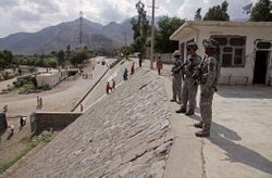
 جنود أمريكان في أسد آباد (أغسطس 2009) | |
| الكنية: آباد - US soldiers use it referencing Asadabad and nearby FOB | |
| الإحداثيات: 34°52′27″N 71°9′10″E / 34.87417°N 71.15278°E | |
| البلد | |
| الولاية | ولاية كنر |
| District | Asadabad District |
| الحكومة | |
| • النوع | جمهورية إسلامية |
| المنسوب | 827 m (2٬713 ft) |
| التعداد | |
| • الإجمالي | 48٬400 |
| منطقة التوقيت | + 4.30 |
أسد آباد (Pashto: اسدآباد) هي مدينة وعاصمة ولاية كونار في شرق أفغانستان على بعد 5 أميال من الحدود مع پاكستان. وهي أقدم مدينة في التاريخ حملت أسم أسد آباد رغم وجود حملت الاسم بعدها وإليها ينسب عدد من الاعلام في التاريخ الإسلامي. وتقع في وادي عند التقاء نهري پچ وكونار بين سلسلتي جبال تجريان بحذى الوادي من الشمال الشرقي إلى الجنوب الغربي.

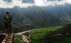
Asadabad is in a mountainous region of the Hindu Kush mountains about 13 km (eight miles) northwest of the Pakistani border and 80 km (50 miles) northeast of Jalalabad, Afghanistan. Asadabad deals with a moderate amount of trade goods. Nawa Pass, that lies about 16 km (10 miles) south of Asadabad, is the next major border crossing point north of the Khyber Pass for the region. The pass is under constant observation due to its relative ease to cross for commerce and its potential usage for smuggling and Taliban insurgents.[2]
التاريخ
The surrounding Kunar Province lies near the historic routes connecting Central Asia, India, and Iran, such as the Silk Road and the Grand Trunk Road through the Khyber Pass, as well as routes through the Hindu Kush mountains. Asadabad lies at the confluence of the two major rivers of the area, the Kunar and the Pech. The region would have come under the borders of various empires of the ages, including the Achaemenid Persians, the Greco-Bactrian Kingdom, etc. It was very close to the paths Alexander the Great passed by on his way from conquering Persia to invading India. Asadabad is also on the eastern boundary of what was Kafiristan - part of Afghanistan not converted to Islam until the 1890s.[3][4][5][6][7]
In the past, the area near Asadabad was called Chaga Serai, with various spellings (Chega Serai, Chagasaray, Chigur Serai, Chughansuraee).
Emperor Babur (late 15th century/early 16th century) claims to have taken over the town as part of his military campaigns in the area. He describes it very briefly in his book, Baburnama. He also mentions relations with the Kaffirs, whom he claims helped defend the town against him.[8]
In the late 19th century/early 20th century the capital of the region was moved from Pushoot/Pasat/Pasad to the present Asadabad location. Over the 20th century, various technical improvements were made such as roads, a shopping area, schools, a bridge, a gas station, etc.[9]
In the opening times of the Soviet Afghan war (1979-1988), Kunar province saw some of the first rebellions against the communist People's Democratic Party of Afghanistan. As punishment, PDPA troops with Soviet advisors massacred the males of the nearby village of Kerala, burying their bodies in a field near the Pech river.[3] Asadabad was later linked to a Soviet military base during the war, which included Spetsnaz.[10] Several Russian websites, like http://asadabad.ru, contain discussions and photos regarding this era.
The rebel Mujahideen later took over the town from the Soviets. Gulbuddin Hekmatyar's Hizb-e-Islami, one of the Peshawar Seven groups, had heavy influence in the area. Osama bin Laden also spent time in Asadabad.[11]
في 14 أغسطس 2021، واصلت حركة طالبان بوتائر متصاعدة زحفها العسكري الرامي إلى إحكام قبضتها على عموم أراضي أفغانستان. وأعلن المتحدث باسم طالبان، ذبيح الله مجاهد، اليوم السبت على حسابه في تويتر عن سيطرة الحركة على مدينة شرنة، مركز ولاية بكتيكا شرق البلاد، وكافة المرافق الحكومية فيها. كما أعلن مجاهد عن استيلاء طالبان أيضاً على مدينة أسد آباد، مركز ولاية كونر شرق البلاد، واستسلام حاكم الولاية وقائد الشرطة ورئيس الاستخبارات المحلية إلى المسلحين، بالإضافة إلى سيطرة الحركة على مناطق أخرى في الولاية.[12]
وأكدت وكالة نوفوستي الروسية صحة الأنباء عن سقوط أسد آباد نقلا عن مسؤول محلي. كما أفاد المتحدث باسم طالبان بأن مسلحي الحركة دخلوا مدينة غرديز، مركز ولاية بكتيا شرق البلاد، واستولوا على السجن المركزي هناك ويقتحمون حالياً مقر الاستخبارات.
بالإضافة إلى ذلك، أعلنت طالبان عن شنها هجوماً جديداً في مسعى للاستيلاء على مدينة مزار شريف الاستراتيجية، مركز ولاية بلخ في شمال البلاد، مؤكدة أنها تشن هجمات من الاتجاهات الأربعة على الأحزمة الدفاعية للمدينة. ولفتت طالبان إلى أن اشتباكات ضارية تدور في المنطقة، زاعمة إحرازها تقدماً ميدانياً مع تكبد القوات الحكومية خسائر فادحة.
وأعلنت طالبان أيضاً أن قواتها استكملت سيطرتها على ولاية بدخشان شمال شرقي البلاد، باستيلائها على مركز مديرية كران ومنجان. في الوقت نفسه، تتحدث تقارير إعلامية عن استسلام مجموعة القوات الحكومية التي كانت تتحصن في مطار قندهار جنوب البلاد إلى طالبان، وذلك بعد أيام من سقوط المدينة في قبضة المسلحين.
ونشرت الحركة على وسائلها الدعائية لقطات تظهر لحظة خروج حاكم قندهار، روح الله خانزادة، من المطار لتسليم نفسه إلى المسلحين.
في غضون ذلك، أكدت هدى أحمدي، المشرعة من ولاية لوكر الواقعة وسط البلاد جنوب شرقي العاصمة كابل، صحة الأنباء عن استيلاء "طالبان" على مركز الولاية مدينة بل علم واحتجازها جميع المسؤولين المحليين. وأوضحت المشرعة أن قوات "طالبان" تسيطر حاليا على عموم الولاية ووصلت إلى منطقة جهار آسياب الواقعة على بعد 11 كلم فقط عن كابل. وسيطرت "طالبان" في الفترة الأخيرة على مراكز 18 على الأقل من أصل الولايات الأفغانية الـ34.
المناخ
يظهر الجدول التالي التغييرات المناخية على مدار السنة لأسد آباد:
| أخفClimate data for أسد آباد | |||||||||||||
|---|---|---|---|---|---|---|---|---|---|---|---|---|---|
| Month | Jan | Feb | Mar | Apr | May | Jun | Jul | Aug | Sep | Oct | Nov | Dec | Year |
| Mean daily maximum °C (°F) | 12.7 (54.9) |
15.0 (59.0) |
19.7 (67.5) |
24.9 (76.8) |
31.3 (88.3) |
37.8 (100.0) |
37.7 (99.9) |
36.1 (97.0) |
33.5 (92.3) |
27.8 (82.0) |
21.0 (69.8) |
14.6 (58.3) |
26.0 (78.8) |
| Mean daily minimum °C (°F) | 1.3 (34.3) |
3.7 (38.7) |
7.9 (46.2) |
12.3 (54.1) |
17.2 (63.0) |
22.6 (72.7) |
24.8 (76.6) |
23.8 (74.8) |
19.7 (67.5) |
12.6 (54.7) |
6.1 (43.0) |
2.2 (36.0) |
12.8 (55.1) |
| Average precipitation mm (inches) | 44 (1.7) |
67 (2.6) |
111 (4.4) |
104 (4.1) |
45 (1.8) |
11 (0.4) |
28 (1.1) |
30 (1.2) |
17 (0.7) |
17 (0.7) |
18 (0.7) |
40 (1.6) |
532 (20.9) |
| Source: climate-data.org | |||||||||||||
أبرز سكانها
أسد أباد هي مسقط رأس المصلح جمال الدين الأفغاني، ولذلك فمبنى بلدية المدينة يحمل اسمه.
المدن الشقيقة
معرض صور
U.S. Ambassador Hans G. Klemm, Coordinating Director of Rule of Law and Law Enforcement, and Kunar Governor Fazlullah Wahidi walking through Asadabad in May 2011
U.S. Army Staff Sgt. Michael Cruz of Cortland, New York, conducts a patrol with Afghan National Security Forces (ANSF) through the streets of Asadabad in August 2009.
مصادر
- ^ "Asadabad (Afghanistan)". Silobreaker. June 14, 2009. Archived from the original on June 16, 2009.
- ^ United States Army Sergeant Moeller, Matthew C. Combined Joint Task Force 82 Public Affairs (November 2009). "Pakistan, Afghanistan, and the United States Agree: Cooperation is the Key to Success Along Border Pass" (PDF). The DISAM Journal. Archived from the original (PDF) on March 24, 2012. Retrieved July 22, 2017.
{{cite journal}}: CS1 maint: numeric names: authors list (link) - ^ أ ب Girardet, Edward (August 8, 2012). Killing the Cranes. Chelsea Green. ISBN 9781603583190 – via Google Books.
- ^ Edwards, David B. (2002). Before Taliban: Genealogies of the Afghan Jihad. University of California Press. Part II. ISBN 9780520926875 – via UC Press E-Books Collection, 1982-2004.
{{cite book}}:|website=ignored (help) - ^ Bearden, Milton; Risen, James (2004). The Main Enemy. Random House. ISBN 9780345472502 – via Google Books.
- ^ "The Journal of the Royal Geographical Society". 42. Royal Geographic Society. 1872: 190 – via Google Books.
{{cite journal}}: Cite journal requires|journal=(help) - ^ Burnes, Sir Alexander (1843). Cabool: A Personal Narrative of a Journey To, and Residence in that City, in the Years 1836, 7, and 8. J. Murray – via Google Books.
- ^ Beveridge, Annette Susannah (1922). The Babur-nama: Memoirs of Babur (in English). Luzac & Co. – via Internet Archive.
{{cite book}}: CS1 maint: unrecognized language (link) - ^ "Asadābād". iranicaonline.org. Encyclopædia Iranica. August 16, 2011. Retrieved July 22, 2017.
- ^ Adamec, Ludwig W. (November 10, 2011). Historical Dictionary of Afghanistan. Scarecrow Press. entry Spetsnaz on page 403. ISBN 9780810878150 – via Google Books.
- ^ Robertson, Phillip (September 6, 2002). "U.S. airstrike near Asadabad". Salon. Retrieved July 22, 2017.
- ^ ""طالبان" تقتحم مزار شريف وباتت على بعد 10 كلم من كابل". روسيا اليوم. 2021-08-14. Retrieved 2021-08-14.
- ^ de Benedetti, Chris (August 17, 2012). "Union City adds new 'sibling' to its list of sister cities". East Bay Times. Digital First Media. Retrieved July 22, 2017.
وصلات خارجية
- ASADĀBĀD - Encyclopedia Iranica
- Asadabad.ru, an entire Russian website devoted to the veterans of the 334th from the Soviet Afghan war
- Vlasenko Map i-42-12, a highly detailed old Russian map of the area


