ملف:Soo Locks-Sault-Ste Marie.png
لا توجد دقة أعلى متوفرة.
Soo_Locks-Sault-Ste_Marie.png (511 × 494 بكسل حجم الملف: 132 كيلوبايت، نوع MIME: image/png)
وصف قصير
| موضوعات | |
|---|---|
| قوائم حسب الولاية |
|
| قائمة الأراضي | |
| قوائم حسب الولايات المرتبطة | |
| أخرى | |
| ⧼wm-license-information-description⧽ |
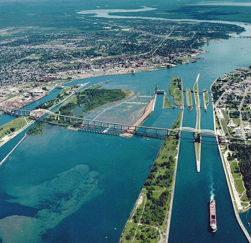
English: Aerial picture of the Soo Locks (downriver view) — in Michigan between Lake Superior and Lake Huron.
Français : Vue aérienne des Écluses du Sault sur la rivière Sainte-Marie, à la frontière américano-canadienne ; ces écluses permettent de franchir le Sault-Sainte-Marie et ainsi de joindre le lac Supérieur au lac Huron.
|
| ⧼wm-license-information-date⧽ | 8/15/1992 per this source |
| ⧼wm-license-information-source⧽ | http://www.lre.usace.army.mil/newsandevents/publications/publications/soolocks-saultste-marie/aerialpicture2/ |
| ⧼wm-license-information-author⧽ | U.S. Army Corps of Engineers soldier or employee |
| ⧼wm-license-information-other-versions⧽ |
ترخيص
قالب:PD-USGov-Military-Army-USACE قالب:Historic Places in Canada
تاريخ الملف
اضغط على زمن/تاريخ لرؤية الملف كما بدا في هذا الزمن.
| زمن/تاريخ | صورة مصغرة | الأبعاد | مستخدم | تعليق | |
|---|---|---|---|---|---|
| حالي | ★ مراجعة معتمدة 15:54، 22 نوفمبر 2023 | | 511 × 494 (132 كيلوبايت) | Pastakhov (نقاش | مساهمات) | Upload https://upload.wikimedia.org/wikipedia/commons/a/ac/Soo_Locks-Sault-Ste_Marie.png |
لا يمكنك استبدال هذا الملف.
وصلات
لا يوجد صفحات تصل لهذه الصورة.
معلومات الصورة (ميتا)
تصنيفات:
- Soo Locks
- Sault Ste. Marie International Bridge
- Sault Ste. Marie Canal
- Dams in Michigan
- Lake freighters
- Whitefish Island
- Hydraulic engineering
- Aerial photographs of Michigan
- Aerial photographs of Sault Ste. Marie, Ontario
- Sault Ste. Marie, Michigan
- August 1992 in Canada
- August 1992 in the United States
- 1992 in Ontario
- 1992 in Michigan
- 1992 aerial photographs of Canada
- 1992 aerial photographs of the United States