الملاحة بعيدة المدى
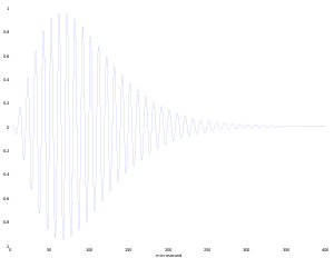
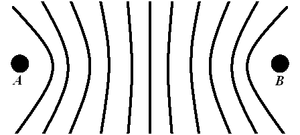
الملاحة البعيدة المدى وتُسمّى أيضًا لوران LORAN (LOng Range Aid to Navigation) هو نظام ملاحة راديوية أرضي يستخدم إرساليات راديوية ذات تردد منخفض تستعمل عدة إرساليات (multilateration) لتحديد موقع و/أو سرعة المستقبل. وهي نظام ملاحي راديوي يساعد السفن والطائرات على تحديد مواقعها. وترسل محطتان أو أكثر تعرفان باسم المحطة الرئيسية والمحطة التابعة الإشارات الراديوية باستمرار، وتستقبل السفينة أوالطائرة هذه الإشارات من خلال أجهزة خاصة. وتقوم هذه الأجهزة بقياس الفترة الزمنية بين النبضات التي تلتقطها من المحطات. ويحدد الفرق في الزمن بين الإشارات التي تلتقطها من محطتين، موقع السفينة أو الطائرة فوق نقطة ما على خط الموقع اللوراني فوق الخريطة. وتوضع علامة على الخريطة لتحديد موقع السفينة أو الطائرة طبقاً للفرق في الزمن بين الإشارات المرسلة من المحطتين.
وفي معظم الحالات، نجد محطة راديوية رئيسية واحدة يقابلها محطة راديوية تابعة من إحدى محطتي التوابع، حيث يسمح هذا الترتيب للملاح أن يقطع خطي موقع لوراني، ليحدد موقع سفينة أو طائرة وبذلك يحسِّن بدرجة كبيرة من دقة نظام الملاحة.
ويستخدم الملاحون نظامًا راديويًا يُعرف باسم لوران ـ سي يستطيع أن يرسل إشارات تقطع 1,600 كم أثناء النهار. وفي بعض الظروف، يصل مداها إلى أكثر من 4,800 كم أثناء الليل عندما تنتقل موجات الراديو منخفضة التردد إلى مسافات أبعد، وبذلك يمكن تحديد أي موقع داخل مدى حوالي نصف كيلومتر.
. . . . . . . . . . . . . . . . . . . . . . . . . . . . . . . . . . . . . . . . . . . . . . . . . . . . . . . . . . . . . . . . . . . . . . . . . . . . . . . . . . . . . . . . . . . . . . . . . . . . . . . . . . . . . . . . . . . . . . . . . . . . . . . . . . . . . . . . . . . . . . . . . . . . . . . . . . . . . . . . . . . . . . . .
Principle
LORAN method
LORAN chains (GRIs)
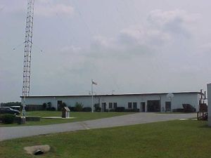
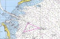
LORAN charts
Timing and Synchronization
Transmitters and antennas
انظر أيضاً: الملاحة؛ الشوران.
قائمة إرساليات LORAN-C
A list of LORAN-C transmitters. Stations with an antenna tower taller than 300 metres (984 feet) are shown in bold.
| المحطة | البلد | السلسلة | تعليق |
|---|---|---|---|
| Afif | Saudi Arabia | Saudi Arabia South (GRI 7030)/Saudi Arabia North (GRI 8830) | |
| Al Khamasin | Saudi Arabia | Saudi Arabia South (GRI 7030)/Saudi Arabia North (GRI 8830) | |
| Al Muwassam | Saudi Arabia | Saudi Arabia South (GRI 7030)/Saudi Arabia North (GRI 8830) | |
| Angissq | Greenland | shutdown on December 31, 1994 | used until July 27, 1964 a 411.48 metre tower |
| Anthorn | UK | Lessay (GRI 6731) | replacement for transmitter Rugby[1] |
| Ash Shayk | Saudi Arabia | Saudi Arabia South (GRI 7030)/Saudi Arabia North (GRI 8830) | |
| Attu, Alaska | United States | North Pacific (GRI 9990)/Russian-American (GRI 5980) | 52°49′44.134″N 173°10′49.528″E / 52.82892611°N 173.18042444°E |
| Balasore | India | Calcutta (GRI 5543) | |
| Barrigada | Guam | shut down | |
| Baudette, Minnesota | United States | North Central U.S. (GRI 8290)/Great Lakes (GRI 8970) | 48°36′49.947″N 94°33′17.915″W / 48.61387417°N 94.55497639°W |
| Berlevåg | Norway | Bø (GRI 7001) | |
| Billamora | India | Bombay (GRI 6042) | |
| Boise City, Oklahoma | United States | Great Lakes (GRI 8970)/South Central U.S. (GRI 9610) | 36°30′21″N 102°53′59″W / 36.50583°N 102.89972°W |
| Bø, Vesterålen | Norway | Bø (GRI 7001)/Eiði (GRI 9007) | |
| Cambridge Bay | Canada | shut down | free-standing lattice tower, used as NDB |
| Cape Race | Canada | Canadian East Coast (GRI 5930)/Newfoundland East Coast (GRI 7270) | used a 411.48 metre tall tower until February 2, 1993, uses now a 260.3 metre tall tower 46°46′32.286″N 53°10′27.606″W / 46.77563500°N 53.17433500°W |
| Caribou, Maine | United States | Canadian East Coast (GRI 5930) / Northeast U.S. (GRI 9960) | 46°48′27″N 67°55′37″W / 46.80750°N 67.92694°W |
| Carolina Beach, North Carolina | United States | Northeast US (GRI 9960)/ Southeast U.S. (GRI 7980) | 34°3′46″N 77°54′46″W / 34.06278°N 77.91278°W |
| Chongzuo | China | China South Sea (GRI 6780) | 22°32′35″N 107°13′22″E / 22.54306°N 107.22278°E |
| Comfort Cove | Canada | Newfoundland East Coast (GRI 7270) | 49°19′53.57″N 54°51′42.57″W / 49.3315472°N 54.8618250°W |
| Dana, Indiana | United States | Great Lakes (GRI 8970)/ Northeast US (GRI 9960) | 39°51′07.658″N 87°29′11.586″W / 39.85212722°N 87.48655167°W |
| Dhrangadhra | India | Bombay (GRI 6042) | 23°00′14″N 71°31′39″E / 23.00389°N 71.52750°E |
| Diamond Harbor | India | Calcutta (GRI 5543) | 22°10′18″N 88°12′25″E / 22.17167°N 88.20694°E |
| Eiði | Faroe Islands | Ejde (GRI 9007) | |
| Estartit | Spain | Mediterranean Sea (GRI 7990); shut down | |
| Fallon, Nevada | United States | U.S. West Coast (GRI 9940) | 39°33′06.740″N 118°49′55.816″W / 39.55187222°N 118.83217111°W |
| Fox Harbour | Canada | Labrador East Coast (GRI 7270)/ Canadian East Coast (GRI 5930) | 52°22′35.252″N 55°42′27.862″W / 52.37645889°N 55.70773944°W |
| George, Washington | United States | Canadian West Coast (GRI 5990)/ U.S. West Coast (GRI 9940) | 47°03′48.096″N 119°44′38.976″W / 47.06336000°N 119.74416000°W |
| Gesashi | Japan | East Asia (GRI 9930)/ North West Pacific (GRI 8930) | |
| Gillette, Wyoming | United States | South Central U.S. (GRI 9610)/ North Central U.S. (GRI 8290) | 44°00′11.305″N 105°37′23.895″W / 44.00314028°N 105.62330417°W |
| Grangeville, Louisiana | United States | South Central U.S. (GRI 9610)/ Southeast U.S. (GRI 7980) | 30°43′33.149″N 090°49′43.046″W / 30.72587472°N 90.82862389°W |
| Havre, Montana | United States | North Central U.S. (GRI 8290) | 48°44′38.589″N 109°58′53.613″W / 48.74405250°N 109.98155917°W |
| Hellissandur | Iceland | shut down on December 31, 1994 | 411.48 metre tall tower, now used for longwave broadcasting of RÚV on 189 kHz |
| Helong | China | China North Sea (GRI 7430) | |
| Hexian | China | China South Sea (GRI 6780) | |
| Jan Mayen | Norway | Bø (GRI 7001)/ Ejde (GRI 9007) | |
| Johnston Island | United States | shut-down | |
| Iwo Jima | Japan | shut down in September 1993, dismantled | used a 411.48 metre tall tower |
| Jupiter, Florida | United States | Southeast U.S. (GRI 7980) | 27°01′58.528″N 080°06′52.875″W / 27.03292444°N 80.11468750°W |
| Kargaburan | Turkey | Mediterranean Sea (GRI 7990); shut down | |
| Kwang Ju | South Korea | East Asia (GRI 9930) | 35°2′24″N 126°32′27″E / 35.04000°N 126.54083°E |
| Lampedusa | Italy | Mediterranean Sea (GRI 7990); shut down | |
| Las Cruces, New Mexico | United States | South Central U.S. (GRI 9610) | 32°4′18″N 106°52′4″W / 32.07167°N 106.86778°W |
| Lessay | France | Lessay (GRI 6731) / Sylt (GRI 7499) | |
| Loop Head | Ireland | was planned (GRI 6731 and 9007), but never operational | |
| Malone, Florida | United States | Great Lakes (GRI 8970) / Southeast U.S. (GRI 7980) | 30°59′38.870″N 085°10′08.751″W / 30.99413056°N 85.16909750°W |
| Minamitorishima | Japan | North West Pacific (GRI 8930) | used until 1985 a 411.48 metre tall tower |
| Nantucket, Massachusetts | United States | Canadian East Coast (GRI 5930) / Northeast U.S. (GRI 9960) | 41°15′12″N 69°58′39″W / 41.25333°N 69.97750°W |
| Narrow Cape, Alaska | United States | North Pacific (GRI 9990) / Gulf of Alaska (GRI 7960) | 57°26′20″N 152°22′11″W / 57.43889°N 152.36972°W |
| Niijima | Japan | North West Pacific (GRI 8930) / East Asia (GRI 9930) | 34°24′12″N 139°16′19″E / 34.40333°N 139.27194°E |
| Patpur | India | Calcutta (GRI 5543) | |
| Pohang | South Korea | North West Pacific (GRI 8930) / East Asia (GRI 9930) | 36°11′5″N 129°20′27″E / 36.18472°N 129.34083°E |
| Port Clarence, Alaska | United States | Gulf of Alaska (GRI 7960)/North Pacific (GRI 9990) | uses a 411.48 metre tall tower 65°14′40.372″N 166°53′11.996″W / 65.24454778°N 166.88666556°W |
| Port Hardy | Canada | Canadian West Coast (GRI 5990) | 50°36′29.830″N 127°21′28.489″W / 50.60828611°N 127.35791361°W |
| Rantum | Germany | Sylt (GRI 7499)/ Lessay (GRI 6731) | |
| Raymondville, Texas | United States | South Central U.S. (GRI 9610)/ Southeast U.S. (GRI 7980) | 26°31′55″N 97°50′0″W / 26.53194°N 97.83333°W |
| Raoping | China | China South Sea (GRI 6780)/ China East Sea (GRI 8930) | 23°43′26″N 116°53′45″E / 23.72389°N 116.89583°E |
| Rongcheng | China | China North Sea (GRI 7430)/ China East Sea (GRI 8930) | 37°3′52″N 122°19′26″E / 37.06444°N 122.32389°E |
| Rugby | UK | experimental (GRI 6731); shut down at the end of July 2007 | |
| Saint Paul, Alaska | United States | North Pacific (GRI 9990) | 57°09′12.350″N 170°15′06.245″W / 57.15343056°N 170.25173472°W |
| Salwa | Saudi Arabia | Saudi Arabia North (GRI 8830)/Saudi Arabia South (GRI 7030) | |
| Searchlight, Nevada | United States | U.S. West Coast (GRI 9940)/South Central U.S. (GRI 9610) | 35°19′18.305″N 114°48′16.881″W / 35.32175139°N 114.80468917°W |
| Sellia Marina | Italy | Mediterranean Sea (GRI 7990); shut down | 38°52′21″N 16°43′7″E / 38.87250°N 16.71861°E |
| Seneca, New York | United States | Great Lakes (GRI 8970)/Northeast U.S. (GRI 9960) | 42°42′51″N 76°49′33″W / 42.71417°N 76.82583°W |
| Shoal Cove, Alaska | United States | Canadian West Coast (GRI 5990)/Gulf of Alaska (GRI 7960) | 55°26′21″N 131°15′19″W / 55.43917°N 131.25528°W |
| Soustons | France | Lessay (GRI 6731) | 43°44′23″N 1°22′50″W / 43.73972°N 1.38056°W |
| Tok, Alaska | United States | Gulf of Alaska (GRI 7960) | 63°19′42.884″N 142°48′31.346″W / 63.32857889°N 142.80870722°W |
| Tokachibuto | Japan | Eastern Russia Chayka (GRI 7950)/ North West Pacific (GRI 8930) | 42°44′37″N 143°43′10″E / 42.74361°N 143.71944°E |
| Upolo Point, Hawaii | United States | shut-down | |
| Værlandet | Norway | Sylt (GRI 7499)/ Ejde (GRI 9007) | |
| Veraval | India | Bombay (GRI 6042) | 20°57′7″N 70°20′13″E / 20.95194°N 70.33694°E |
| Williams Lake | Canada | Canadian West Coast (GRI 5990) | 51°57′58.876″N 122°22′01.686″W / 51.96635444°N 122.36713500°W |
| Xuancheng | China | China North Sea (GRI 7430)/ China East Sea (GRI 8930) | |
| Yap | Micronesia | shut down in 1987, dismantled | used a 304.8 metre tall tower |
. . . . . . . . . . . . . . . . . . . . . . . . . . . . . . . . . . . . . . . . . . . . . . . . . . . . . . . . . . . . . . . . . . . . . . . . . . . . . . . . . . . . . . . . . . . . . . . . . . . . . . . . . . . . . . . . . . . . . . . . . . . . . . . . . . . . . . . . . . . . . . . . . . . . . . . . . . . . . . . . . . . . . . . .
انظر أيضاً
- CHAYKA, the Russian counterpart of LORAN
- Alpha, the Russian counterpart of the Omega Navigation System, still in use as of 2006.
- OMEGA, the Western counterpart of the Alpha Navigation System, no longer in use.
- Decca Navigator System, a British system that used phase difference instead of time difference.
- SHORAN
- Oboe (navigation)
- G-H (navigation)
- GEE (navigation)
- GPS
الهامش
- ^ "Electronic Position Fixing System" (PDF). Admiralty Notices to Mariners. United Kingdom Hydrographic Office (26/07). 2007-06-28. Retrieved 2008-01-19.
{{cite journal}}: Check date values in:|date=(help); Cite has empty unknown parameter:|coauthors=(help)
- Jennet Conant, Tuxedo Park: A Wall Street Tycoon and the Secret Palace of Science That Changed the Course of World War II (New York: Simon & Schuster, 2002, ISBN 0-684-87287-0) pp. 231-232.
- Department of Transportation and Department of Defense (2006-02). "2005 Federal Radionavigation Plan" (PDF). Retrieved 2006-02-26.
{{cite web}}: Check date values in:|year=(help); Cite has empty unknown parameter:|accessyear=(help)
وصلات خارجية
- The Case for LORAN- It is a good backup, and very accurate.
- United States Coast Guard's official site- how to use LORAN C
- 9th Pulse Modulation / LORAN Data Channel (LDC) - will provide information using pulse position modulation of the broadcast signal.
- United States National Institute of Standards and Technology Site- Using LORAN C for time-keeping.
- LORAN-C Transmitter (Rantum) in the Structurae database
- Hellissandur Transmission Tower in the Structurae database
- former LORAN-C transmitter mast, now used for longwave broadcasting
- LORAN-C facility antenna (Gillette, Wyoming) in the Structurae database
- LORAN-C facility antenna (Port Clarence, Alaska) in the Structurae database
- http://www.jproc.ca/hyperbolic/loran_a.html More in-depth discussion of the Loran-A system.
- http://www.jproc.ca/hyperbolic/loran_b_d.html Histories of Lorans-B, -D, and "-F".
- Integrated GPS/Loran Prototypes for Aviation Applications
- Loran-C Introduction: eLoran
- The Migration to Enhanced or eLoran
- The Case for eLoran at GPS World
- GNSS/eLoran for Timing and Frequency by Locus, Inc.
- Loran's Capability to Mitigate the Impact of a GPS Outage on GPS Position, Navigation, and Time Applications by Locus, Inc.
- New Potential of Low-Frequency Radionavigation in the 21st Century Ph.D. dissertation
- LORAN-C chains in service
- List of active LORAN-C transmitters
- SDR in action: The last LORAN-C receiver is a technical description of using a software-defined radio to decode LORAN-C signals.
- New UK eLORAN service provision news article News article re: UK leading the way in eLORAN service provision.
- eLORAN vs Loran-C at InsideGNSS - Short article describing the innovations in eLORAN.
- History of LORAN
