طية مقعرة Syncline

In structural geology, a syncline is a fold with younger layers closer to the center of the structure, whereas an anticline is the inverse of a syncline. A synclinorium (plural synclinoriums or synclinoria) is a large syncline with superimposed smaller folds.[1] Synclines are typically a downward fold (synform), termed a synformal syncline (i.e. a trough), but synclines that point upwards can be found when strata have been overturned and folded (an antiformal syncline).
السمات
On a geologic map, synclines are recognized as a sequence of rock layers, with the youngest at the fold's center or hinge and with a reverse sequence of the same rock layers on the opposite side of the hinge. If the fold pattern is circular or elongate, the structure is a basin. Folds typically form during crustal deformation as the result of compression that accompanies orogenic mountain building.
أمثلة بارزة
- Powder River Basin, Wyoming, US
- Sideling Hill roadcut along Interstate 68 in western Maryland, US, where the Rockwell Formation and overlying Purslane Sandstone are exposed
- Forêt de Saou syncline in Saou, France
- Southland Syncline in the southeastern corner of the South Island of New Zealand, including The Catlins and the Hokonui Hills
- Strathmore Syncline, Scotland
- Wilpena Pound, Flinders Ranges, South Australia
- Fort Valley, Shenandoah County, Virginia
- Hondo Syncline in the Picuris Mountains of New Mexico, an example of an overturned syncline[2]
- Afikpo syncline, Nigeria
معرص صور

Syncline exposed in Sideling Hill roadcut

Snow-dusted syncline in Provo Canyon, Utah

Road cut near Fort Davis, Texas showing a syncline
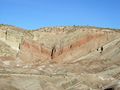
Rainbow Basin Syncline in the Barstow Formation near Barstow, California
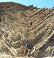
Syncline in the lower parking lot of Calico Ghost Town; the ductile folding is at the base and the brittle is above.

Synclinal fold in Silurian Wills Creek Formation or Bloomsburg Formation at Roundtop Hill (Maryland)

East wall of Bear Valley Strip Mine, near Shamokin, Pennsylvania

Syncline in Navajo Sandstone, Upheaval Dome, Canyonlands National Park, Utah

Satellite view of part of New Zealand's Southland Syncline, showing parallel folds running northwest–southeast

Wilpena Pound, a synclinal basin in the Flinders Ranges of South Australia


انظر أيضاً
المراجع
- ^ Synclinorium. (2008). In Encyclopædia Britannica. Retrieved May 03, 2008, from Encyclopædia Britannica Online: http://www.britannica.com/EBchecked/topic/578375/synclinorium
- ^ Bauer, Paul W.; Williams, Michael L. (August 1989). "Stratigraphic nomenclature ol proterozoic rocks, northern New Mexico-revisions, redefinitions, and formalization" (PDF). New Mexico Geology. 11 (3): 45–52. doi:10.58799/NMG-v11n3.45. Retrieved 15 April 2020.