خليج سودا
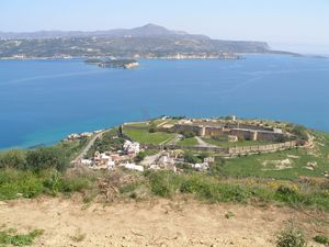
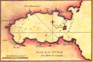
خليج سودا (باليونانية: Κόλπος Σούδας؛ Souda Bay) هو خليج وميناء طبيعي بالقرب من بلدة سودا على الساحل الشمالي الغربي لجزيرة كريت اليونانية. الخليج يبلغ طوله نحو 15 كم ويتراوح عرضه بين 2 - 4 كم، وميناء طبيعي عميق. وقد تشكل بين شبه جزيرة أكروتيري ورأس دراپانو، ويجري في اتجاه غرب إلى شرق. الخليج تحيط به التلال من الجانبين، ببرزخ منخفض نسبياً وضيق في الغرب بالقرب من خانيا.
بالقرب من بوغاز خليج سودا، بين أكروتيري وبلدة كاليڤس، توجد مجموعة من الجزر الصغيرة عليها تحصينات أقامتها جمهورية البندقية. أكبر جزيرة هي جزيرة سودا، التي أعطت اسمها للخليج.
Souda Bay is now a popular tourist destination although there are no formal public beaches designed in the area, due to the presence of the Crete Naval Base, a major naval installation of the Hellenic Navy and NATO في شرق المتوسط. Villages such as Megala Chorafia and Kalives afford fine views of the bay, and house-building, particularly for foreigners and tourist companies, is spreading along the bay.
التاريخ
القديم والوسيط
There have been port facilities on the bay since ancient times, previously serving the city of Aptera. Aptera was founded in the 7th Century BC and was an important city during the ancient and early Byzantine periods. وقد دمرتها إمارة كريت العربية في ع820. The nearest large ancient city was Kydonia, which flourished في العصر المينوي era on Crete; moreover, during a portion of the first millennium BC Kydonia held influence over Aptera.[1]
الحكم البندقي
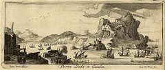
احتل البنادقة المنطقة في 1207. في 1571 an Ottoman military force landed at Souda and caused major destruction في منطقة خانيا. حصّن البنادقة جزيرة سودا بين 1570 و 1573, in order to protect the area from Ottoman raiders and pirates. إلا أن خليج سودا ظل موبوءاً بالقراصنة طوال القرون 15، 16 ، 17. تمكن البنادقة من الاحتفاظ بالجزر الاستراتيجية في خليج سودا حتى 1715، لما يزيد عن ثلاثين عاماً بعد سقوط كريت في يد العثمانيين.
الحكم المصري والعثماني
في 1822 هبط جيش مصري مكون من نحو 10,000 جندي بقيادة حسن پاشا في سودا لإخماد الثورة الكريتية 1821.
بعد الثورة الكريتية 1866–69، شيد العثمانيون حصوناً في أپتيرا (حصن أپتيرا) و كالامي (حصن عز الدين) وثكنات ومستشفى عسكري وقاعدة بحرية. كما بنوا بلدة سودا على رأس الخليج، لتصبح الميناء الجديد لبلدة خانيا القريبة. الحصن في كالامي مازال مستخدماً كسجن. القاعدة البحرية اِفتُتحت رسمياً في 1872، بحضور السلطان عبد العزيز.
دولة كريت (1898–1913)
In the period of the semi-independent Cretan State the area attracted international interest, as it offered port facilities to foreign naval vessels enforcing the Cretan autonomy. The first High Commissioner, Prince George of Greece, disembarked at Souda Bay on December 9, 1898. The church of Saint Nicholas was built during this period.
الاتحاد مع اليونان وحتى الحرب العالمية الثانية (1913–1940)
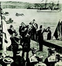
In 1913, events marking the union of Crete with Greece took place on Souda Island. On February 1 the metallic Ottoman flag, the last symbol of Ottoman rule, was removed and replaced by the Greek flag on May 1. Also the ruined chapel was rebuilt and dedicated to Saint George.
In 1916 the British liner SS Minnewaska, requisitioned by the British Army as a troops carrier, struck a mine and was beached at Souda Bay.
After 1923 the area was used as an Hellenic Army base, housing the artillery units of 5th Infantry Division.[2]
1940–1945
During World War II British and Commonwealth troops withdrew from mainland Greece in April 1941 and 25,000 men, mainly from New Zealand and Australia, disembarked at Souda Bay.
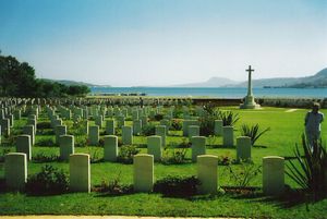
في مايو 1941، أثناء هجوم ألماني يُدعى "العملية مركور"، تراجع الحلفاء من منطقة سودا إلى سفاكيا in the south of the island. The Germans occupied the area until 1945. The Souda Bay Allied War Cemetery, the principal Allied war cemetery of the island, designed by architect Louis de Soissons, is located at Souda.
المنشآت العسكرية
Souda Bay is the location of three major military installations: the Hellenic Navy's Crete Naval Station,[3] which also houses the NATO Maritime Interidiction Operational Training Centre; the Hellenic Air Force's Souda Air Base on Akrotiri Peninsula, base of the 115th Combat Wing;[4] and the NATO Missile Firing Installation.[5]
جمع الطوابع والتاريخ البريدي
During Turkish rule an Ottoman post office operated in Souda until 1892.[6] The Cretan State post office opened officially in 1912, although a postal agent operated there previously, possibly since 1908.
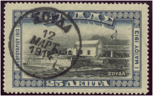
A special local stamp depicting Souda Island was issued on November 15, 1913 to commemorate the union with Greece and was sold only by Cretan post offices. This stamp, printed by Bradbury Wilkinson and Company in the United Kingdom, is commonly called the "Souda Issue".[7]
انظر أيضاً
الهامش
- ^ C. Michael Hogan, Cydonia, The Modern Antiquarian, Jan. 23, 2008
- ^ "Naval Dock Crete history" (in Greek). Retrieved 2008-04-26.
{{cite web}}: CS1 maint: unrecognized language (link) - ^ "Crete Naval Station" (in Greek). Hellenic Navy. Retrieved 2008-04-26.
{{cite web}}: CS1 maint: unrecognized language (link) - ^ "HAF 115 Combat Wing". Retrieved 2008-02-16.
- ^ "Nato Missile Fire Installation". Retrieved 12 September 2010. (إنگليزية) (باليونانية)
- ^ Constantinos Sitarenios, ed. (2009). Vlastos Foreign Post Offices. Vol. 4. Athens, Greece: Orestes Vlastos Ltd. p. 68.
- ^ Karamitsos, A. (2004). Hellas 2004: Stamp Catalog and Postal History, Volume II. Thessaloniki: A. Karamitsos. ISBN 960-87500-6-7.
