الجبال الملعونة
| Prokletije | |
|---|---|
| Проклетије | |
 مايا يزرتسا عن بعد في الجبال الملعونة | |
| أعلى نقطة | |
| القمة | مايا يزرتسا، ألبانيا |
| الارتفاع | 2،694 m (8،839 ft) |
| البروز | 1800 |
| الإحداثيات | 42°26′30″N 19°48′45″E / 42.44167°N 19.81250°E |
| الأبعاد | |
| الطول | 1000 NW-SE |
| التسمية | |
| الكنية | الألپ الألبانية Alpet Shqiptare |
| Bjeshkët e Nemuna Error {{native name checker}}: parameter value is malformed (help) | |
| الترجمة | الجبال الملعونة |
| النطق | پروكلتيـّة |
| الجغرافيا | |
| البلد | ألبانيا |
| السلسلة الأم | الألپ الدينارية |
| الجيولوجيا | |
| التجبل | طية من ارتطام الصفيحة الأفريقية بالصفيحة الأوراسية |
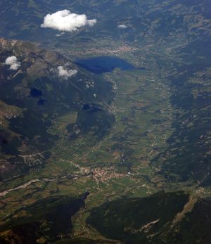
الجبال الملعونة أو پروكلتية (Prokletije ؛ سيريلية صربية: Проклетије؛ تـُنطق [prɔklɛ̌tijɛ]؛ ألبانية: Bjeshkët e Nemuna؛ وكلاهما تُترجمان إلى "الجبال الملعونة")، كما تُعرف بإسم الألپ الألبانية (Alpet Shqiptare) و الجبال اللعينة Accursed Mountains، هي سلسلة جبال في غرب شبه جزيرة البلقان، تمتد من شمال ألبانيا إلى كوسوڤو[أ] وشرق الجبل الأسود. قمتها في ألبانيا، Maja Jezercë بارتفاع 2,694 متر، هي أعلى نقطة، وثاني أعلى قمة في ألبانيا والأعلى في كل الألپ الدينارية.
Both the highest peak in Montenegro, Zla Kolata at 2،534 m (8،314 ft) (which is also partially in Albania) and the highest in Kosovo, Gjeravica at 2،656 m (8،714 ft), are here. The highest peak in Albania, however, is Mount Korab, part of the Korab range, at 2،764 m (9،068 ft) high and in the east of the country on the border with the جمهورية مقدونيا (making it Macedonia's highest point in addition).
The southernmost glaciers in Europe were recently discovered in the Albanian part of the range.[محل شك] The regional economy is based mainly on agriculture, emigrant remittances and tourism.
الاسم
Ptolemy mentioned Mons Bertiscus, which has been connected to Prokletije.[1]قالب:Vn
الموقع والتضاريس
The Prokletije mountains, the southernmost part of the Dinaric Alps, stretch more than 40 miles from Skadar Lake along the Montenegrin–Albanian border in the southwest to Kosovo in the northeast. These points are at 42°45' and 42°15' N in the Mediterranean zone of the western شبه جزيرة البلقان.[2][3] The southern boundary of the Prokletije is found at the river Drin and its tributary Valbona. In a broader sense the Prokletije also include the mountain ranges to Kosovska Mitrovica with the Hajla and Mokna massifs. Some authors, however, see the river Lim as the northern boundary of the Prokletije in geological terms.
الجيولوجيا


الأنهار والبحيرات
أعلى القمم
القمم فوق 2,600 متر
- مايا يزرتسا (2,694 متر؛ في ألبانيا)
- Đeravica/Gjeravica (2،656 m أو 8،714 ft؛ في كوسوڤو)
- Maja Grykat e Hapëta (2،625 m أو 8،612 ft؛ في ألبانيا)
القمم فوق 2,500 متر
- Maja e Radohimës (2،570 m أو 8،432 ft؛ في ألبانيا)
- Maja e Popljuces (2،569 m أو 8،428 ft؛ في ألبانيا)
- Maja Briaset (2،567 m أو 8،422 ft؛ في ألبانيا)
- Maja e Hekurave (2،561 m أو 8،402 ft؛ في ألبانيا)
- Rodi e Kollatës (2،556 m أو 8،386 ft؛ في ألبانيا)
- Maja e Shënikut (2،554 m أو 8،379 ft؛ في ألبانيا)
- Maja Tat (2،543 m أو 8،343 ft؛ في ألبانيا)
- Gusan (2،539 m أو 8،330 ft؛ في ألبانيا وكوسوڤو)
- Zla Kolata/Kollata e Keqe (2،534 m أو 8،314 ft؛ في ألبانيا & Montenegro)
- Marijaš/Marijash (2،533 m أو 8،310 ft؛ في كوسوڤو)
- Dobra Kolata/Kolata e Mirë (2،524 m أو 8،281 ft؛ في ألبانيا & Montenegro)
- Rosni Vrh/Maja e Rosit (2،524 m أو 8،281 ft; in Montenegro)
- Žuti kamen/Guri i Kuq (2،522 m أو 8،274 ft؛ في كوسوڤو)
- Maja Kokervhake (2،508 m أو 8،228 ft؛ في ألبانيا)
- Rops/Maja e Ropës (2،502 m أو 8،209 ft؛ في كوسوڤو)
القمم فوق 2,400 متر
- Maja Shkurt (2،499 m أو 8،199 ft؛ في ألبانيا)
- Maja e Malësores (2،490 m أو 8،169 ft؛ في ألبانيا)
- Karanfili (Veliki Vrh, Kremeni Vrh, Maja Gurt e Zjarmit) (2،490 m أو 8،169 ft; in Montenegro)[4]
- Maja e Ragamit (2،472 m أو 8،110 ft؛ في ألبانيا)
- Maja Bojs (2،461 m أو 8،074 ft؛ في ألبانيا)
- Koprivnik/Kopranik (2،460 m أو 8،071 ft; in Kosovo)
- Maja Vukoces (2،450 m أو 8،038 ft؛ في ألبانيا)
- Veternik (2،410 m أو 7،907 ft؛ في ألبانيا)
- شكلزن (2,407 متر؛ في ألبانيا)
- Maja e Thatë (2،406 m أو 7،894 ft؛ في ألبانيا)
- Pasji Peak (2،405 m أو 7،890 ft; in Kosovo & Montenegro)
- Maja Bogiçaj (2،404 m أو 7،887 ft؛ في ألبانيا وكوسوڤو)
- هايلا (2،403 m أو 7،884 ft؛ في كوسوڤو والجبل الأسود)
قمم تحت 2,400 متر
- رسولية (2،382 m أو 7،815 ft)
- Streoc (2،377 m أو 7،799 ft)
- Tromeđa (2،366 m أو 7،762 ft)
- Žljeb (2،365 m أو 7،759 ft)
- Maja e Kakisë (2،360 m أو 7،743 ft)
- Liqenat (2،341 m أو 7،680 ft)
- Rrasa e Zogut (2،305 m أو 7،562 ft)
- Hajla e Vëranocit (2،281 m أو 7،484 ft)
- Junik (2،280 m أو 7،480 ft)
- Maja e Elbunit (2،231 m أو 7،320 ft)
- Mali i Deçanit (2،200 m أو 7،218 ft)
- Maja Harapit (2،218 m أو 7،277 ft)
- Maja Trojan (2،190 m أو 7،185 ft)
- Pogled (2،155 m أو 7،070 ft)
- Maja Dramadol (2،120 m أو 6،955 ft)
- Beleg (2،102 m أو 6،896 ft)
- Maja e Ershellit (2،067 m أو 6،781 ft)
- Maja e Vjelakut (2،014 m أو 6،608 ft)
- Hajla e Shkrelit (2،011 m أو 6،598 ft)
- Maja e Madhe (2،011 m أو 6،598 ft)
- Maja e Grebenit (1،864 m أو 6،115 ft)
- Lice Mountain (1،799 m أو 5،902 ft)
- Maja e Veleçikut (1،725 m أو 5،659 ft)
المناخ
The Prokletije is on the whole the wettest area of Europe. In the village of Boga in the dry valley, precipitation is 3،033 ميليمتر (119.4 in) per year, and otherwise 2،000 إلى 2،500 ميليمتر (79 إلى 98 in) per year is normal.[3] At higher elevations snow is found even in summer, except in very dry years.[5] In winter some villages in the Albanian part of the Prokletije are completely cut off from the rest of the world for months due to the very heavy snow.[6]
التثلج
Today (as around 2015) on the shady northern slopes of the Prokletije, there are at least five active glaciers that probably formed during the late Holocene period, and some inactive glaciers between 1,980 and 2,420 meters high.[5][7][8] The trough valleys of Ropojani, Grbaja and Valbona were carved by miles of glaciers during the last Ice Age.
النبيت
Fauna
Large mammal species that have long been extinct in other regions are found here, such as the Eurasian brown bear, grey wolf, red fox, European wildcat, roe deer, fallow deer, red deer, wild boar and European otter.[6][9][10]
المنتزهات الوطنية
Settlement, economy and transport

انظر أيضاً
- Valbonë Valley National Park
- Theth National Park
- Bjeshkët e Nemuna National Park
- الألپ الدينارية
- Rugova Mountains
- Malësia
- Mokna
- Bogićevica
- Rugova Canyon
- Rugova (Region)
- Valbonë (river)
- Theth
- Shkrel
- Kelmend
- Žljeb mountain
- Shalë
- Lake Komani Ferry
- Tourism in Albania
- Tourism in Montenegro
- Tourism in Kosovo
ملاحظات
- ^ أ ب Kosovo is the subject of a territorial dispute between Serbia and the local Albanian majority. The Assembly of Kosovo declared its independence on 17 February 2008, a move that is recognised and the Republic of China (Taiwan), but not by Serbia, which claims it as part of its sovereign territory.
الهامش
- ^ John Lemprière; Lorenzo L. Da Ponte; John David Ogilby (1838). Bibliotheca Classica: Or, a Dictionary of All the Principal Names and Terms Relating to the Geography, Topography, History, Literature, and Mythology of the Antiquity and of the Ancients, with a Chronological Table. W.E. Dean.
- ^ Website des Montenegrinischen Tourismusministeriums
- ^ أ ب Akademia e Shkencave e RPSSH: Fjalor enciklopedik shqiptar, Tirana 1985 und Gjeografia fizike e Shqipërisë, Tirana 1990
- ^ http://www.summitpost.org/karanfili/154538
- ^ أ ب Milovan Milivojević, Ljubomir Menković and Jelena Ćalić (November 2008). "Pleistocene glacial relief of the central part of Mt. Prokletije (Albanian Alps)". Quaternary International. V. 190 (1, 1): 112–122. doi:10.1016/j.quaint.2008.04.006.
- ^ أ ب Michael Galaty. "Dr. Michael Galaty in Northern Albania". Millsaps College – News & Events. Retrieved 16 August 2008.
- ^ "Phil Hughes: Twenty-first Century Glaciers and Climate in the Prokletije Mountains, Albania". Arctic, Antarctic, and Alpine Research. 41 (4): 455–459. 2009. doi:10.1657/1938-4246-41.4.455.
- ^ خطأ استشهاد: وسم
<ref>غير صحيح؛ لا نص تم توفيره للمراجع المسماةmanu - ^ خطأ استشهاد: وسم
<ref>غير صحيح؛ لا نص تم توفيره للمراجع المسماةbradt - ^ Wolfgang Fremuth (Herausgeber): Albania - Guide to its Natural Treasures, Verlag Herwig Klemp, Tirana 2000, ISBN 3-931323-06-4
وصلات خارجية
أكاديمية
- Prokletije on BirdLife
- Peace parks of Prokletije
- Montenegrin Prokletije
- Prokletije at summitpost.org
- GTZ. Successful Cooperation – Sustainable Results: Examples from Europe, Caucasus and Central Asia, Berlin, 2010
Tourism
- Albanian Challenge project
- Journey to Valbona Blog in Albania
- Discovery Kelmend & Shkrel in Albania
- Komani Lake Ferry
- Prokletije National Park Travel Guide in Montenegro
- Organized Tours to the Albanian Alps
- Peaks of the Balkans Project
- Rugova Canyon Travel Guide in Kosovo
- Thethi Guide in Albania
مقالات إخبارية
- Ottery, James (26 May 2015). "Epic Walks: the Accursed Mountains, Albania". Telegraph.
- Neville, Tim (29 March 2013). "Hiking Beyond Borders in the Balkans". New York Times. Retrieved 31 March 2013.
- Knott, Jonathan (18 May 2012). "Walking in Albania's 'Accursed Mountains'". The Guardian. Retrieved 26 May 2012.
- Rue, Geraldine (20 March 2017). "Le charme des Balkans dans les Alpes albanaises #1". Le Monde. (French)
- Pages using gadget WikiMiniAtlas
- Native name checker template errors
- Pages using infobox mountain with unknown parameters
- Pages using infobox mountain with conflicting parameters
- Articles containing صربية-language text
- Articles containing ألبانية-language text
- Pages using Lang-xx templates
- مقالات ذات عبارات محل شك
- Pages using div col with unknown parameters
- Articles with hatnote templates targeting a nonexistent page
- سلاسل جبال اوروبا
- منتزهات وطنية في الجبل الأسود
- سلاسل جبال في ألبانيا
- سلاسل جبال في كوسوڤو
- جبال الجبل الأسود
- الجبال الملعونة
- Two-thousanders of Albania
- Two-thousanders of Kosovo
- Two-thousanders of Montenegro


