بركان پواس
| بركان پواس Poás Volcano | |
|---|---|
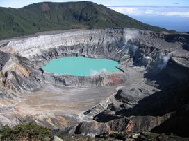 فوهة بركان پواس | |
| أعلى نقطة | |
| الارتفاع | 2,708 m (8,885 ft) |
| الإحداثيات | 10°12′N 84°12′W / 10.2°N 84.2°W |
| الجغرافيا | |
| الموقع | كوستاريكا |
| السلسلة الأم | Cordillera Central |
| الجيولوجيا | |
| نوع الجبل | Stratovolcano |
| آخر ثوران | 2010 |
| التسلق | |
| أسهل السبل | Hike |
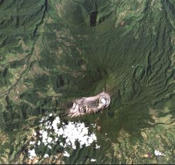
بركان پواس، بالإسپانية Volcán Poás، هو بركان طبقي نشط في منتزه بركان پواس الوطني بوسط كوستاريكا. ثار پواس 40 مرة منذ عام 1828، بما في ذلك أبريل 2017 حين أُخلي الزوار والسكان.[1] The volcano and surrounding park were closed for nearly 17 months, with a 2.5 kilometer safety perimeter established around the erupting crater.[2] As of September 1, 2018 the park has reopened with limited access only to the crater observation area and requires a reservation to be made on the National Park Website. Adjacent trails to Lake Botos as well as the museum at the visitor center remained closed. The volcano erupted briefly twice in September 2019.[3]
. . . . . . . . . . . . . . . . . . . . . . . . . . . . . . . . . . . . . . . . . . . . . . . . . . . . . . . . . . . . . . . . . . . . . . . . . . . . . . . . . . . . . . . . . . . . . . . . . . . . . . . . . . . . . . . . . . . . . . . . . . . . . . . . . . . . . . . . . . . . . . . . . . . . . . . . . . . . . . . . . . . . . . . .
بحيرات الفوهة
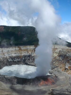
There are two crater lakes near the summit. The northern lake is known as the Laguna Caliente ("hot lagoon") and is located at a height of 2,300 m in a crater approximately 0.3 km wide and 30 m deep. It is one of the world's most acidic lakes. The acidity varies after rain and changes in volcanic activity, sometimes reaching a pH of almost 0. The bottom of this lake is covered with a layer of liquid sulfur.[4] Acidity, lake temperature fluctuations, and a complex, toxic sulfur and iron chemistry (conjectured to be like conditions on early Earth and Mars) limits aquatic life to specially-adapted Acidiphilium bacteria.[5] Above ground, acid gases create acid rain and acid fog, causing damage to surrounding ecosystems and often irritation of eyes and lungs.
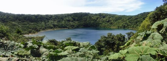
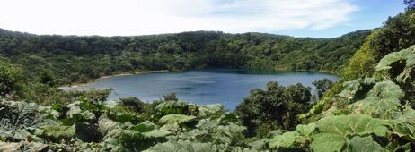
Lake Botos, the southern lake, fills an inactive crater, which last erupted in 7500 BC. It is cold and clear, and is surrounded by a cloud forest within the National Park boundaries.
تاريخ ثورات البركان
On May 17, 1953, an eruption occurred that started a cycle that lasted until 1956. At least two people were reported missing.[6]
Poás was near the epicenter of a 6.1-magnitude earthquake in January 2009 that killed at least forty people and affected Fraijanes, Vara Blanca, Cinchona (the most affected area), the capital San José, and the Central Valley region of Costa Rica.
There was also eruptive activity in 2009 involving minor phreatic eruptions and landslides within the northern active crater. Poás eruptions often include geyser-like ejections of crater-lake water.
On February 25, 2014, a webcam from the Volcanological and Seismological Observatory of Costa Rica (OVSICORI) captured the moment a dark cloud exploded about 1,000 feet in the air from a massive crater of the Poás Volcano. This volcano remains active today.[7][8] Poás is one of 9 volcanoes currently monitored by the Deep Earth Carbon Degassing Project. The project is collecting data on the carbon dioxide and sulfur dioxide emission rates from subaerial volcanoes.[9]
2017 Activity
On April 9, 2017, National Park officials placed restrictions on visitors at Poas due to an increased volume of toxic gases at the summit crater.[10] An explosion on April 12 caused park officials to close the popular park to visitors. The measure was termed "temporary."[11] Some nearby residents were also evacuated.[1]
On April 14, 2017, two eruptions at 07:39 and 07:57 created an over three kilometer ash and vapor column.[12] Further explosions occurred April 16.[13]
Following a substantial blast on April 22 that sent incandescent rocks over a large area which damaged park buildings and infrastructure, Costa Rica President Luis Guillermo Solis toured the surrounding towns the following two days. Business owners described the negative financial impacts the volcano park closure were causing, and Solis released a video in Spanish and English urging potential tourists to visit the nearby community shops and restaurants. He also promised emergency agencies would continue to make updated reports on the eruption.[14] As of September 1, 2018, the National Park has re-opened with limited access and revised regulations. Visitors are required to make an online reservation to enter the park and the number of visitors and time allowed at the crater is limited. Only the main crater observation area is open as of September 2018. Adjacent trails including the trail to the Lake Botos remain closed.
2019 Activity
- February 11, 2019: According to the Volcanological and Seismological Observatory of Costa Rica (OVSICORI), the eruption began at 1:50 a.m. Monday and sent a column of ash 200 meters above the crater.[15]
- September 30, 2019, 05:41: Eruption of ash and solid material, with a 2 kilometer column, in contrast of previous water vapor activities on September 23, 2019.[16]
Lake Botos is an inactive crater within Poás Volcano National Park
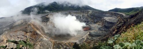
Fumarole activity at the Poás crater
IUGS geological heritage site
In respect of it being 'an iconic and type example of an arc shield-like massive stratovolcano and type example of an active crater lake complex', the International Union of Geological Sciences (IUGS) included 'The Poás volcano' in its assemblage of 100 'geological heritage sites' around the world in a listing published in October 2022. The organisation defines an IUGS Geological Heritage Site as 'a key place with geological elements and/or processes of international scientific relevance, used as a reference, and/or with a substantial contribution to the development of geological sciences through history.'[17]
انظر أيضا
المصادر
- ^ أ ب "New Eruption at Poas Volcano in Costa Rica Forces Evacuation of Residents as Preventive Measure". 2017-04-13.
- ^ "Poás Volcano closed indefinitely; Turrialba keeps spewing ash". 18 April 2017.
- ^ "Poás Volcano erupts again, sends ash cloud 2 km into atmosphere". 30 September 2019.
- ^ O. Vaselli, F. Tassi, A.Minissale, G. Montegrossi, E. Duarte, E.Fernandez, E. Bergamaschi (2003), Fumarole migration and fluid geochemistry at Poás Volcano (Costa Rica), The Geological Society of London., ISBN 9781862391369, https://books.google.com/books?id=zsPoH-aCJqwC&q=Po%C3%A1s+acid+rain+Laguna+Caliente&pg=PA256
- ^ Justin L. Wang, Nicholas B. Dragone, Geoffrey Avard, Brian M. Hynek (28 January 2022), "Microbial Survival in an Extreme Martian Analog Ecosystem: Poás Volcano, Costa Rico", Frontiers in Astronomy and Space Sciences 9: 1, doi:, Bibcode: 2022FrASS...9....1W
- ^ (Video) Así asustó a los ticos el Poás ¡en 1953!
- ^ NY Daily News 2/25/14
- ^ Costa Rica Star News 12/28/16
- ^ "DECADE Installations at Turrialba and Poás". Deep Carbon Observatory. Archived from the original on 12 May 2017. Retrieved 26 September 2016.
- ^ "Gas, vapor at Poás Volcano prompts preventive measures". 11 April 2017.
- ^ "UPDATE: Poás Volcano eruption prompts temporary closure of national park". 13 April 2017.
- ^ Volcán Poás registra erupción de más de 3 kilómetros de altura
- ^ "Poas Volcano National Park in Costa Rica will Remain Closed due to Continuous Eruptions". 2017-04-16.
- ^ "President Solís tours Poás Volcano region following strong explosion". 25 April 2017.
- ^ Zúñiga, Alejandro (11 February 2019). "Poás Volcano registers overnight eruption, National Park closed Monday".
- ^ Zúñiga, Alejandro (30 September 2019). "Poás Volcano erupts again, sends ash cloud 2 km into atmosphere". Retrieved 30 September 2019.
- ^ "The First 100 IUGS Geological Heritage Sites" (PDF). IUGS International Commission on Geoheritage. IUGS. Retrieved 13 November 2022.
وصلات خارجية
