مقاطعة ماكنتوش، أوكلاهوما
McIntosh County | |
|---|---|
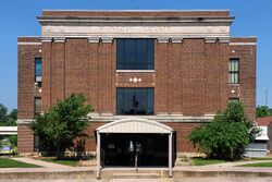
 The McIntosh County Courthouse in Eufaula. | |
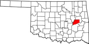
 الموقع ضمن ولاية Oklahoma | |
 موقع Oklahoma ضمن الولايات المتحدة | |
| الإحداثيات: 35°23′N 95°40′W / 35.38°N 95.67°W | |
| البلد | |
| State | |
| تأسست | 1907 |
| Seat | Eufaula |
| Largest city | Checotah |
| المساحة | |
| • الإجمالي | 712 ميل² (1٬840 كم²) |
| • البر | 618 ميل² (1٬600 كم²) |
| • الماء | 94 ميل² (240 كم²) 13%% |
| التعداد (2010) | |
| • الإجمالي | 20٬252 |
| • Estimate (2019) | 19٬596 |
| • الكثافة | 33/sq mi (13/km2) |
| Congressional district | 2nd |
مقاطعة ماكنتوش إنگليزية: McIntosh County هي إحدى مقاطعات ولاية أوكلاهوما في الولايات المتحدة الأمريكية.
. . . . . . . . . . . . . . . . . . . . . . . . . . . . . . . . . . . . . . . . . . . . . . . . . . . . . . . . . . . . . . . . . . . . . . . . . . . . . . . . . . . . . . . . . . . . . . . . . . . . . . . . . . . . . . . . . . . . . . . . . . . . . . . . . . . . . . . . . . . . . . . . . . . . . . . . . . . . . . . . . . . . . . . .
السياسة
Despite a wide Democratic registration advantage, the county -- like every Oklahoma county since 2000 -- has avoided the party entirely in presidential elections in the 21st century. The county was slower than most of its size to give large margins to national Republican candidates (Barack Obama still cracked 40% in 2008), but Donald Trump received 69.1% of the vote in 2016.
#3333FF #E81B23 #DDDDBB| Voter Registration and Party Enrollment as of January 15, 2019[1] | |||||
|---|---|---|---|---|---|
| Party | Number of Voters | Percentage | |||
| Democratic | 6,860 | 58.14% | |||
| Republican | 3,665 | 31.06% | |||
| Others | 1,256 | 10.79% | |||
| Total | 11,799 | 100% | |||
| Year | Republican | Democratic | Third parties |
|---|---|---|---|
| 2020 | 74.1% 6,172 | 24.4% 2,031 | 1.6% 132 |
| 2016 | 69.1% 5,505 | 26.7% 2,123 | 4.2% 335 |
| 2012 | 61.9% 4,509 | 38.1% 2,779 | |
| 2008 | 59.6% 4,903 | 40.4% 3,320 | |
| 2004 | 51.1% 4,692 | 48.9% 4,488 | |
| 2000 | 44.3% 3,444 | 54.1% 4,206 | 1.7% 131 |
| 1996 | 31.2% 2,400 | 54.9% 4,219 | 13.9% 1,072 |
| 1992 | 28.2% 2,225 | 53.0% 4,184 | 18.8% 1,484 |
| 1988 | 39.5% 2,665 | 59.9% 4,041 | 0.5% 36 |
| 1984 | 50.9% 3,646 | 48.6% 3,479 | 0.6% 40 |
| 1980 | 43.3% 2,925 | 54.0% 3,654 | 2.7% 184 |
| 1976 | 30.3% 1,822 | 68.9% 4,145 | 0.8% 48 |
| 1972 | 63.9% 3,216 | 33.5% 1,686 | 2.6% 132 |
| 1968 | 33.7% 1,532 | 38.7% 1,759 | 27.6% 1,254 |
| 1964 | 29.0% 1,428 | 71.0% 3,497 | |
| 1960 | 50.4% 2,221 | 49.6% 2,185 | |
| 1956 | 44.1% 2,149 | 55.9% 2,728 | |
| 1952 | 43.3% 2,295 | 56.7% 3,007 | |
| 1948 | 28.2% 1,442 | 71.8% 3,674 | |
| 1944 | 44.5% 2,569 | 55.3% 3,190 | 0.2% 12 |
| 1940 | 47.9% 3,487 | 51.8% 3,771 | 0.2% 17 |
| 1936 | 38.7% 2,470 | 61.1% 3,898 | 0.3% 16 |
| 1932 | 19.2% 1,077 | 80.8% 4,533 | |
| 1928 | 56.9% 2,742 | 42.4% 2,044 | 0.7% 35 |
| 1924 | 37.3% 1,675 | 60.6% 2,723 | 2.2% 97 |
| 1920 | 44.8% 2,358 | 50.2% 2,642 | 4.9% 259 |
| 1916 | 28.0% 898 | 54.4% 1,743 | 17.5% 561 |
| 1912 | 34.2% 970 | 46.7% 1,325 | 19.1% 542 |
الاقتصاد
The county economy has been based primarily on farming and ranching. Corn was the principal crop until 1900, when cotton superseded it (as measured by acreage) around the middle of the 20th century. Other crops such as sorghum, oats and wheat also became important. However, construction of a dam and the resulting Eufaula Lake inundated much of the best cropland, causing a large-scale decline in agriculture. Cotton farming essentially ceased in the county by the mid 1970s. Cattle ranching has remained important, continuing to rise throughout the century. By 2000, the county reported 55,000 head of cattle.[3]
Completion of Eufaula Lake in 1964 generated revenue from hydroelectric power, stimulated tourism, and produced companion businesses like boat building and general retail.[3]
Mineral resources such as oil, natural gas, limestone, sand and gravel have also been important. While there are ample coal deposits, much of it has a high ash and sulfur content, so little except the low-sulfur type has been mined.[3]
التجمعات
المدن
البلدات
Census-designated places
Unincorporated communities
NRHP sites
The following sites in McIntosh County are listed on the National Register of Historic Places:
- Checotah Business District, Checotah
- Checotah City Hall, Checotah
- Checotah MKT Depot, Checotah
- C. L. Cooper Building, Eufaula
- Eufaula Armory, Eufaula
- Eufaula Business District, Eufaula
- First Soil Conservation District Dedication Site, Eufaula
- Honey Springs Battlefield, Rentiesville
- Johnson Lake Shelters, Warner
- McIntosh County Courthouse, Eufaula
- Methodist Episcopal Church, South, Checotah
- Oklahoma Odd Fellows Home at Checotah, Checotah
- Rock Front, Vernon
- Slippery Moss Shelter, Texanna
- Tabor House, Checotah
الهامش
- ^ "Oklahoma Registration Statistics by County" (PDF). OK.gov. January 15, 2019. Retrieved February 27, 2019.
- ^ Leip, David. "Dave Leip's Atlas of U.S. Presidential Elections". uselectionatlas.org. Retrieved March 29, 2018.
- ^ أ ب ت خطأ استشهاد: وسم
<ref>غير صحيح؛ لا نص تم توفيره للمراجع المسماةEOHC-McIntoshCo
- Pages using gadget WikiMiniAtlas
- Short description is different from Wikidata
- Coordinates on Wikidata
- مقاطعات Oklahoma
- Pages using infobox U.S. county with unknown parameters
- Articles containing إنگليزية-language text
- Pages using Lang-xx templates
- Articles with hatnote templates targeting a nonexistent page
- مقاطعات ولاية أوكلاهوما الأمريكية
