مارثاز ڤنيارد
الاسم الأصلي: Martha's Vineyard Noepe Nickname: The Vineyard, The Rock | |
|---|---|
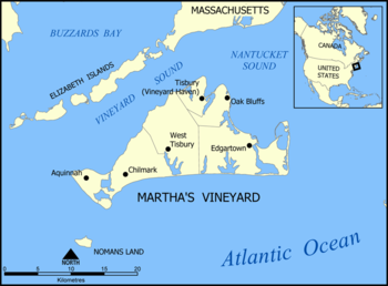
 Map of Martha's Vineyard | |
| الجغرافيا | |
| الموقع | مقاطعة دوكس، مساتشوستس |
| الإحداثيات | 41°24′N 70°37′W / 41.400°N 70.617°W |
| الأرخبيل | جزر إلزابث |
| إجمالي الجزر | 3 |
| الجزر الرئيسية | 2 |
| المساحة | 415.6 sq mi (1،076 km2) |
| الطول | 20٫5 mi (33 km) |
| أعلى منسوب | 311 ft (94٫8 m) |
| أعلى نقطة | Peaked Hill |
| الإدارة | |
United States | |
| State | Massachusetts |
| County | Dukes |
| السكان | |
| التعداد | 16,535 (2010) |
| الكثافة السكانية | 39٫8 /sq mi (15٫37 /km2) |
| معلومات إضافية | |
| الموقع الرسمي | mvy |
مارثاز ڤنيارد (Martha's Vineyard ؛ وامپانواگ: [Noepe] Error: {{Lang}}: text has italic markup (help)) هي جزيرة تقع جنوب كيپ كد في مساتشوستس، وتُعرف بكونها مستعمرة اصطياف الأثرياء. وتضم جزيرة تشاپاكوِدِك الأصغر، التي كانت حتى عام 2007 جزء من نفس الكتلة الأرضية قبل أن تفصلها عاصفة.
Often called just "The Vineyard," the island has a land area of 100 ميل مربع (260 km2). It is the 58th largest island in the United States and the third largest on the East Coast of the United States. It is also the largest island not connected to mainland by a bridge or tunnel on the East Coast of the United States.
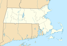
It is located in the Commonwealth of مساتشوستس, as a part of Dukes County, which also includes Cuttyhunk, as well as the island of Nomans Land, which is a US Wildlife preserve, and was a US Naval practice bombing range until 1996. The Vineyard was also home to one of the earliest known deaf communities in the United States; consequently, a special sign language, Martha's Vineyard Sign Language (MVSL), developed on the island.

The 2010 census reported a year-round population of 16,535 residents;[1] however, the summer population can swell to over 100,000 people. About 56% of the Vineyard’s 14,621 homes are seasonally occupied.[2]
Martha's Vineyard is primarily known as a summer colony, and is accessible only by boat and air. However, its year-round population has grown considerably since the 1960s.[3][4]
A study by the Martha's Vineyard Commission found that the cost of living on the island is 60 percent higher than the national average and housing prices are 96 percent higher.[5] A study of housing needs by the Commission found that the average weekly wage on Martha's Vineyard was “71 per cent of the state average, the median home price was 54 per cent above the state’s and the median rent exceeded the state’s by 17 per cent.”[6]
التاريخ
الاستكشاف
Originally inhabited by the Wampanoag, Martha's Vineyard was known in their language as Noepe, or "land amid the streams." In 1642 the Wampanoag numbered somewhere around 3,000 on the island. By 1764, that number had dropped to 313.[7]
العصر الحديث
The linguist William Labov wrote his MA essay on changes in the Martha's Vineyard dialect of English.[8] The 1963 study is widely recognized as a seminal work in the foundation of sociolinguistics.[9]
المناخ
| بيانات المناخ لـ مارثاز ڤنيارد (إدگارتاون، مساتشوستس) | |||||||||||||
|---|---|---|---|---|---|---|---|---|---|---|---|---|---|
| الشهر | ينا | فب | مار | أبر | ماي | يون | يول | أغس | سبت | أكت | نوف | ديس | السنة |
| القصوى القياسية °ف (°س) | 65 (18) |
64 (18) |
79 (26) |
90 (32) |
91 (33) |
95 (35) |
95 (35) |
99 (37) |
92 (33) |
88 (31) |
74 (23) |
67 (19) |
99 (37) |
| متوسط القصوى اليومية °ف (°س) | 39.5 (4.2) |
41.0 (5.0) |
46.7 (8.2) |
55.5 (13.1) |
65.0 (18.3) |
74.1 (23.4) |
80.0 (26.7) |
79.3 (26.3) |
73.3 (22.9) |
63.4 (17.4) |
54.4 (12.4) |
44.8 (7.1) |
59.8 (15.4) |
| المتوسط اليومي °ف (°س) | 31.8 (−0.1) |
33.4 (0.8) |
39.0 (3.9) |
47.4 (8.6) |
56.6 (13.7) |
65.8 (18.8) |
71.8 (22.1) |
71.3 (21.8) |
65.3 (18.5) |
55.2 (12.9) |
46.7 (8.2) |
37.3 (2.9) |
51.9 (11.1) |
| متوسط الدنيا اليومية °ف (°س) | 24.2 (−4.3) |
25.9 (−3.4) |
31.2 (−0.4) |
39.3 (4.1) |
48.2 (9.0) |
57.6 (14.2) |
63.6 (17.6) |
63.3 (17.4) |
57.3 (14.1) |
47.0 (8.3) |
39.1 (3.9) |
29.7 (−1.3) |
44.0 (6.7) |
| الصغرى القياسية °ف (°س) | −6 (−21) |
−9 (−23) |
−7 (−22) |
12 (−11) |
28 (−2) |
37 (3) |
45 (7) |
41 (5) |
32 (0) |
0 (−18) |
14 (−10) |
−5 (−21) |
−9 (−23) |
| متوسط تساقط الأمطار inches (mm) | 3.85 (98) |
3.20 (81) |
4.92 (125) |
4.27 (108) |
3.54 (90) |
3.74 (95) |
3.04 (77) |
3.98 (101) |
3.69 (94) |
4.09 (104) |
4.32 (110) |
4.30 (109) |
46.94 (1٬192) |
| متوسط هطول الثلج inches (cm) | 5.7 (14) |
8.3 (21) |
3.4 (8.6) |
0.2 (0.51) |
0 (0) |
0 (0) |
0 (0) |
0 (0) |
0 (0) |
0 (0) |
0.2 (0.51) |
7.5 (19) |
15.5 (39) |
| Average precipitation days (≥ 0.01 in) | 12 | 10 | 11 | 12 | 12 | 10 | 8 | 9 | 9 | 10 | 12 | 12 | 125 |
| Source: Western Regional Climate Center (normals 1981–2010, extremes and snow 1946-2012)[10] | |||||||||||||
المراجع
- ^ Martha's Vineyard Times 23 March 2011: “Martha's Vineyard population grew in last decade, Census shows”
- ^ Martha's Vineyard Commission: “Population and Housing Profile of Martha’s Vineyard”
- ^ “Each decade from 1970 to 2000, Martha's Vineyard’s year-round population grew about a third, for a total of 145% or about 3 to 4% per year (46%, 30% and 29% in each respective decade). … The population of Martha’s Vineyard was 14,901 in the 2000 Census and was estimated at 15,582 in 2004. (Dukes County was 14,987 in 2000 and 15,669 in 2004.)” (Martha's Vineyard Commission: “Population and Housing Profile of Martha’s Vineyard”.)
- ^ “Dukes County, which includes the six towns on Martha's Vineyard and Gosnold, grew by more than 10 percent between 2000 and 2010, according to Census data released Tuesday, gaining nearly 1,548 residents. The Island's population increased from 14,987 to 16,535.” (Martha's Vineyard Times 23 March 2011: “Martha's Vineyard population grew in last decade, Census shows”
- ^ Seccombe, Mike. “Cost of Living Found Shockingly High Here.”\ Vineyard Gazette Online.
- ^ “Martha’s Vineyard Housing Needs Assessment, Partial Draft/Interim Report #1, Sections 1 to 4”
- ^ A People's History of the United States, By Howard Zinn, p. 16
- ^ Bas van Elburg, Possible Origins of Certain Nonstandard Verb Forms in the Dialect of Tristan Da Cunha. 21 December 2000.
- ^ [1][dead link]
- ^ "General Climate Summary Tables". Western Regional Climate Center. Retrieved February 22, 2013.
الهامش
- Gookin,Historical Collections, 53; Railton, "Vineyard's First Harvard men," 91-112.
- Monaghan, E.J.(2005). Learning to Read and Write in Colonial America University of Massachusetts Press. Boston: MA

