مديرية ماي سواي
ماي سواي
แม่สรวย Mae Suai | |
|---|---|
 A rice field in Mae Suai | |
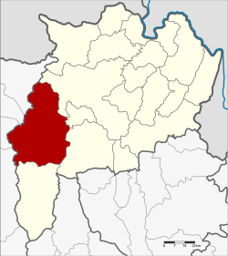
 موقع المديرية في محافظة تشيانغ راي | |
| الإحداثيات: 19°39′23″N 99°32′33″E / 19.65639°N 99.54250°E | |
| البلد | |
| المحافظة | تشيانگ راي |
| المساحة | |
| • الإجمالي | 1٬428٫61 كم² (551٫59 ميل²) |
| التعداد (2008) | |
| • الإجمالي | 82٬989 |
| • الكثافة | 56٫3/km2 (146/sq mi) |
| منطقة التوقيت | UTC+7 (ICT) |
| Postal code | 57180 |
| Geocode | 5710 |
ماي سواي ( Mae Suai ؛ بالتايلندية: แม่สรวย؛ IPA: [mɛ̂ː sǔaj]؛ تايلندية الشمالية: แม่สรวย، nod) هي مديرية (amphoe) في الجزء الغربي من محافظة تشيانغ راي، بشمال تايلند.
الجغرافيا
المديريات المجاورة هي (من الشمال الشرقي مع عقارب الساعة): Mueang Chiang Rai, ماي لاو، Phan, Wiang Pa Pao, Phrao, Chai Prakan, Fang, and Mae Ai في محافظة تشيانغ ماي.
تمتد سلسلة جبال خون تان من الشمال إلى الجنوب بحذى الجانب الغربي للمديرية. نهر سواي، رافد نهر لاو، يعطي اسمه للمديرية.
التاريخ
The district was created in 1905, when the districts Mueang Wiang Pa Pao and Mueang Phong were merged.[1] Originally spelled แม่ซ่วย، التهجي الحالي تم اعتماده قبل عام 1917.
الإدارة
الإدارة المركزية
مديرية ماي سواي تنقسم إلى 7 subdistricts (Tambon)، والتي تنقسم بدورها إلى 131 قرية إدارية (موبان).
| No. | الاسم | Thai | Villages | Pop.[2] |
|---|---|---|---|---|
| 1. | ماي سواي | แม่สรวย | 17 | 9,432 |
| 2. | Pa Daet | ป่าแดด | 22 | 11,966 |
| 3. | ماي فريك | แม่พริก | 13 | 5,650 |
| 4. | سي ثوي | ศรีถ้อย | 12 | 6,723 |
| 5. | ثا كو | ท่าก๊อ | 28 | 18,468 |
| 6. | واوي | วาวี | 27 | 25,476 |
| 7. | Chedi Luang | เจดีย์หลวง | 12 | 7,087 |
الحكم المحلي
There are 3 subdistrict municipalities (Thesaban Tambon) in the district:
- Mae Suai (Thai: เทศบาลตำบลแม่สรวย) consisting of parts of the subdistrict Mae Suai.
- Chedi Luang (Thai: เทศบาลตำบลเจดีย์หลวง) consisting of parts of the subdistrict Chedi Luang.
- Wiang Suai (Thai: เทศบาลตำบลเวียงสรวย) consisting of parts of the subdistrict Mae Suai.
There are 6 subdistrict administrative organizations (SAO) in the district:
- Pa Daet (Thai: องค์การบริหารส่วนตำบลป่าแดด) consisting of the complete subdistrict Pa Daet.
- Mae Phrik (Thai: องค์การบริหารส่วนตำบลแม่พริก) consisting of the complete subdistrict Mae Phrik.
- Si Thoi (Thai: องค์การบริหารส่วนตำบลศรีถ้อย) consisting of the complete subdistrict Si Thoi.
- Tha Ko (Thai: องค์การบริหารส่วนตำบลท่าก๊อ) consisting of the complete subdistrict Tha Ko.
- Wawi (Thai: องค์การบริหารส่วนตำบลวาวี) consisting of the complete subdistrict Wawi.
- Chedi Luang (Thai: องค์การบริหารส่วนตำบลเจดีย์หลวง) consisting of parts of the subdistrict Chedi Luang.
المراجع
- ^ แจ้งความกระทรวงมหาดไทย (PDF). Royal Gazette (in Thai). 22 (39): 950–951. 1905-12-24. Archived from the original (PDF) on 27 January 2012.
{{cite journal}}: CS1 maint: unrecognized language (link) - ^ "Population statistics 2018" (in Thai). Department of Provincial Administration. Retrieved 2020-06-19.
{{cite web}}: CS1 maint: unrecognized language (link)
وصلات خارجية
 Chiang Rai Province travel guide from Wikivoyage
- amphoe.com
قالب:Chiang Rai خطأ لوا في وحدة:Authority_control على السطر 278: attempt to call field '_showMessage' (a nil value).
- Pages using gadget WikiMiniAtlas
- CS1: Julian–Gregorian uncertainty
- CS1 uses التايلاندية-language script (th)
- Short description is different from Wikidata
- Coordinates on Wikidata
- Articles containing تايلندية-language text
- Articles containing تايلندية الشمالية-language text
- Pages using Lang-xx templates
- مديريات محافظة تشيانغ راي


