كامينيتس، ڤويڤودية ڤارميا-مازوريا
كامينيتس
Kamieniec | |
|---|---|
Village | |
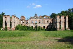
 أطلال القصر في 2011 | |
| الإحداثيات: 53°45′N 19°22′E / 53.750°N 19.367°E | |
| Country | |
| الڤويڤودية | ڤارميا-مازوريا |
| المقاطعة | Iława |
| گمينا | Susz |
| First mentioned | 1321 |
| التعداد | 430 |
| منطقة التوقيت | UTC+1 (CET) |
| • الصيف (التوقيت الصيفي) | UTC+2 (CEST) |
| لوحة السيارة | NIL |
كامينيتس (Kamieniec ؛ [kaˈmjɛɲɛt͡s] أو كامينيتس سوسكي Kamieniec Suski) هي قرية في administrative district of Gmina Susz, within Iława County, Warmian-Masurian Voivodeship, in northern Poland.[1] It lies approximately 4 kilometres (2 mi) north-east of Susz, 22 km (14 mi) north-west of Iława, and 75 km (47 mi) west of the regional capital Olsztyn.
التاريخ

The oldest known mention of the village comes from 1321. In 1454 King Casimir IV Jagiellon incorporated the village and region to the Kingdom of Poland upon the request of the Prussian Confederation, and after the subsequent Thirteen Years’ War (1454–1466) it was part of Poland as a fief held by the State of the Teutonic Knights.[2] From the 18th century it was part of the Kingdom of Prussia, and from 1871 to 1945 it was part of Germany. In 1807 Napoleon stayed at the local palace for several weeks with his mistress Maria Walewska. There, Napoleon signed a decree establishing the elite 1st Polish Light Cavalry Regiment of the Imperial Guard,[3] and a Franco-Persian treaty. In the village are the ruins of the Finckenstein Palace, burned by the Soviets in 1945 during World War II. After the defeat of Nazi Germany in World War II, in 1945, the village became again part of Poland.
Notable residents
- Friedrich Ferdinand Alexander zu Dohna-Schlobitten (1771–1831), Prussian politician
المراجع
- ^ "Central Statistical Office (GUS) - TERYT (National Register of Territorial Land Apportionment Journal)" (in Polish). 2008-06-01.
{{cite web}}: CS1 maint: unrecognized language (link) - ^ Górski, Karol (1949). Związek Pruski i poddanie się Prus Polsce: zbiór tekstów źródłowych (in Polish). Poznań: Instytut Zachodni. pp. 54, 96–97, 214–215.
{{cite book}}: CS1 maint: unrecognized language (link) - ^ "Sformowanie 1 Pułku Szwoleżerów-Lansjerów Gwardii". Muzeum Historii Polski (in Polish). Retrieved 25 December 2020.
{{cite web}}: CS1 maint: unrecognized language (link)
