مقاطعة هاوائي، هاوائي
Hawaii County | |
|---|---|
 | |
 الموقع ضمن ولاية Hawaii | |
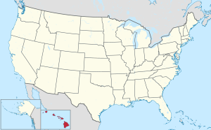
 موقع Hawaii ضمن الولايات المتحدة | |
| الإحداثيات: 19°35′N 155°30′W / 19.58°N 155.5°W | |
| البلد | |
| State | |
| تأسست | 1905 |
| السمِيْ | Hawaii (Island) |
| Seat | Hilo |
| Largest community | Hilo |
| الحكومة | |
| • Mayor | Mitch Roth |
| المساحة | |
| • الإجمالي | 5٬086٫70 ميل² (13٬174٫5 كم²) |
| • البر | 4٬028٫02 ميل² (10٬432٫5 كم²) |
| • الماء | 1٬058٫69 ميل² (2٬742�0 كم²) 20.81% |
| التعداد (2020) | |
| • الإجمالي | 200٬629 |
| • الكثافة | 46/sq mi (17٫7/km2) |
| منطقة التوقيت | UTC−10 (Hawaii–Aleutian) |
| • الصيف (التوقيت الصيفي) | HADT |
| Congressional district | 2nd |
| الموقع الإلكتروني | www |
Hawaii County (بالهاواي: [Kalana o Hawaiʻi] Error: {{Lang}}: text has italic markup (help); officially known as the County of Hawaiʻi) is a county in the U.S. state of Hawaii in the Hawaiian Islands. It is coextensive with the Island of Hawaii, often called the "Big Island" to distinguish it from the state as a whole. The 2020 Census population was 200,629.[1] The county seat is Hilo. There are no incorporated cities in Hawaii County (see Hawaii Counties). The Hilo Micropolitan Statistical Area includes all of Hawaii County. Hawaii County has a mayor–council form of government. In terms of geography, Hawaii County is the most expansive county in the state and the most southerly county in the United States.
The mayor of Hawaii County is Mitch Roth, who took office in 2020. Legislative authority is vested in the nine-member Hawaii County Council.
Hawaii County is one of seven counties in the United States to share the same name as the state they are in (the other six are Arkansas County, Idaho County, Iowa County, New York County, Oklahoma County, and Utah County).[2]
. . . . . . . . . . . . . . . . . . . . . . . . . . . . . . . . . . . . . . . . . . . . . . . . . . . . . . . . . . . . . . . . . . . . . . . . . . . . . . . . . . . . . . . . . . . . . . . . . . . . . . . . . . . . . . . . . . . . . . . . . . . . . . . . . . . . . . . . . . . . . . . . . . . . . . . . . . . . . . . . . . . . . . . .
الجغرافيا
Hawaii County has a total area of 5,086.70 square miles (13,174.5 km2); 4,028.02 square miles (10,432.5 km2) is land and 1,058.69 square miles (2,742.0 km2) is water[3] (mostly all off the ocean shoreline but counted in the total area by the U.S. Census Bureau). The county's land area comprises 62.7 percent of the state's land area. It is the highest percentage by any county in the United States. (Delaware's Sussex County comes in second at 48.0 percent, while Rhode Island's Providence County is third at 39.55 percent.)
الطرق الرئيسية
- Invalid type: HI
- Invalid type: HI
- Invalid type: HI
- Invalid type: HI
- Invalid type: HI
- Invalid type: HI
- Invalid type: HI
- Invalid type: HI
- Invalid type: HI
- Invalid type: HI
المقاطعة المجاورة
- Maui County - northwest
السكان
| التعداد التاريخي | |||
|---|---|---|---|
| التعداد | Pop. | %± | |
| 1900 | 46٬843 | — | |
| 1910 | 55٬382 | 18٫2% | |
| 1920 | 64٬895 | 17٫2% | |
| 1930 | 73٬325 | 13�0% | |
| 1940 | 73٬276 | −0٫1% | |
| 1950 | 68٬350 | −6٫7% | |
| 1960 | 61٬332 | −10٫3% | |
| 1970 | 63٬468 | 3٫5% | |
| 1980 | 92٬053 | 45�0% | |
| 1990 | 120٬317 | 30٫7% | |
| 2000 | 148٬677 | 23٫6% | |
| 2010 | 185٬079 | 24٫5% | |
| 2020 | 200٬629 | 8٫4% | |
| 2023 (تق.) | 207٬615 | [4] | 3٫5% |
اعتبارا من 2010[تحديث], the island had a resident population of 185,079.[5] There were 64,382 households in the county. The population density was 17.7/km2 (46/sq mi). There were 82,324 housing units at an average density of 8/km2 (21/sq mi). The racial makeup of the county was 34.5% White, 29.2% from two or more races, 22.6% Asian, 12.4% Native Hawaiian or other Pacific Islander and 0.7% African American; 11.8% of the population were Hispanics or Latinos of any race. The largest ancestry groups were:
- 9.8% Japanese
- 9.6% German
- 8.6% Filipino
- 8.5% Native Hawaiian
- 8.3% Portuguese
- 6.9% Irish
- 5.7% English
- 5.1% Puerto Rican
- 3.2% Mexican
- 2.5% French
- 2.2% Italian
- 1.9% Spanish
- 1.7% Scottish
- 1.5% Scotch-Irish
- 1.5% Swedish
- 1.1% Polish
- 1.1% Dutch
- 1.0% Norwegian
There were 64,382 households, out of which 32.2% had children under the age of 18 living with them, 50.6% were married couples living together, 13.2% had a woman whose husband did not live with her, and 30.4% were non-families. 23.1% of all households were made up of individuals, and 8.0% had someone living alone who was 65 years of age or older. The average household size was 2.75 and the average family size was 3.24.
The age distribution was 26.1% under 18, 8.2% from 18 to 24, 26.2% from 25 to 44, 26.0% from 45 to 64, and 13.5% who were 65 or older. The median age was 39 years. For every 100 females, there were 100 males. For every 100 females age 18 and over, there were 98 males.
41.3% of the people on Hawaii island are religious, meaning they affiliate with a religion. 18.4% are Catholic; 3.7% are of another Christian faith; 5.1% are LDS; 5.0% are of an Eastern faith; 0.1% are Muslim.[بحاجة لمصدر]
الحكومة والبنية التحتية
حكومة المقاطعة
دقة حقائق هذا المقال ربما تكون قد قـُوِّضت بسبب معلومات بالية. السبب المعطى هو: Redistricted 2011 and expected to redistrict again late 2021. (September 2021) |
Executive authority is vested in the mayor of Hawaii County, who is elected for a four-year term. Since 2004, the election by the voters has been on a nonpartisan basis. In 2020, Mitch Roth was elected mayor, succeeding Harry Kim, who lost reelection after being defeated in the primary election.[6] Legislative authority is vested in a nine-member County Council. Members of the County Council are elected on a nonpartisan basis to two-year terms from single-member districts.[7] As of December 2016, Hawaii County Council has a female supermajority for the first time, with six women and three men.[8]
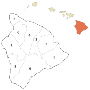
Administrative districts were originally based on the traditional land divisions called Moku of Ancient Hawaii. Some more heavily populated districts have since been split into North and South districts to make them more comparable on a population basis.
The number following each district is the Tax Map Key (TMK) number, used to locate state property information. They are assigned in a counter-clockwise order beginning on the eastern side of the island.[9]
| Nr. | District | Area mi2 |
Population 2000 |
moku | Map |
|---|---|---|---|---|---|
| 1 | Puna | 499.45 | 31,335 | Puna | 
|
| 2 | South Hilo | 394.38 | 47,386 | Hilo | |
| 3 | North Hilo | 370.65 | 1,720 | Hilo | |
| 4 | Hāmākua | 580.50 | 6,108 | Hāmākua | |
| 5 | North Kohala | 132.92 | 6,038 | Kohala | |
| 6 | South Kohala | 351.72 | 13,131 | Kohala | |
| 7 | North Kona | 489.01 | 28,543 | Kona | |
| 8 | South Kona | 335.38 | 8,589 | Kona | |
| 9 | Kaʻū | 922.22 | 5,827 | Kaʻū | |
| Hawaiʻi County | 4028.02 | 148,677 | 6 moku |
County council districts do not directly match the property tax districts because of the variation in the population density of voters in urban areas to rural areas; Hilo & Kailua (Kailua-Kona) towns are densely populated areas, while other districts such as Kaʻū, Puna, Hāmākua, and North & South Kohala are more sparsely populated.[10]
Several government functions are administered at the county level that are at the state or municipal level in other states. For example, the county has its own office of liquor control.[11]
حكومة الولاية
Hawaii Department of Public Safety previously operated the Kulani Correctional Facility in Hawaii County, on the Island of Hawaii.[12] In 2009, the Hawaii Department of Public Safety announced that Kulani Correctional Facility would close.[13]
نتائج الانتخابات الرئاسية
| السنة | الجمهوري | الديمقراطي | حزب ثالث | |||
|---|---|---|---|---|---|---|
| رقم. | % | رقم. | % | رقم. | % | |
| 2020 | 26,897 | 30٫63% | 58,731 | 66٫88% | 2,186 | 2٫49% |
| 2016 | 17,501 | 26٫98% | 41,259 | 63٫61% | 6,107 | 9٫41% |
| 2012 | 14,753 | 23٫25% | 47,224 | 74٫42% | 1,477 | 2٫33% |
| 2008 | 14,866 | 22٫22% | 50,819 | 75٫94% | 1,231 | 1٫84% |
| 2004 | 22,032 | 38٫18% | 35,116 | 60٫86% | 554 | 0٫96% |
| 2000 | 17,050 | 33٫52% | 28,670 | 56٫37% | 5,140 | 10٫11% |
| 1996 | 13,516 | 27٫60% | 27,262 | 55٫66% | 8,199 | 16٫74% |
| 1992 | 15,460 | 30٫36% | 25,725 | 50٫52% | 9,731 | 19٫11% |
| 1988 | 17,125 | 41�00% | 24,091 | 57٫68% | 552 | 1٫32% |
| 1984 | 20,707 | 52٫90% | 17,866 | 45٫64% | 570 | 1٫46% |
| 1980 | 14,247 | 39٫73% | 17,630 | 49٫16% | 3,984 | 11٫11% |
| 1976 | 15,366 | 48٫37% | 15,960 | 50٫24% | 439 | 1٫38% |
| 1972 | 16,832 | 59٫09% | 11,652 | 40٫91% | 0 | 0�00% |
| 1968 | 9,625 | 37٫41% | 15,819 | 61٫49% | 283 | 1٫10% |
| 1964 | 4,962 | 19٫87% | 20,011 | 80٫13% | 0 | 0�00% |
| 1960 | 12,251 | 51٫46% | 11,557 | 48٫54% | 0 | 0�00% |
. . . . . . . . . . . . . . . . . . . . . . . . . . . . . . . . . . . . . . . . . . . . . . . . . . . . . . . . . . . . . . . . . . . . . . . . . . . . . . . . . . . . . . . . . . . . . . . . . . . . . . . . . . . . . . . . . . . . . . . . . . . . . . . . . . . . . . . . . . . . . . . . . . . . . . . . . . . . . . . . . . . . . . . .
المحال
Census-designated places
- Ainaloa
- Black Sands
- Captain Cook
- Discovery Harbour
- Eden Roc
- Fern Acres
- Fern Forest
- Halaula
- Hawaiian Acres
- Hawaiian Beaches
- Hawaiian Ocean View
- Hawaiian Paradise Park
- Hawi
- Hilo
- Holualoa
- Honalo
- Honaunau-Napoopoo
- Honokaa
- Honomu
- Kahaluu-Keauhou
- Kailua
- Kaiminani
- Kalaoa
- Kalapana
- Kaloko
- Kamaili
- Kapaau
- Keaau
- Kealakekua
- Kukuihaele
- Kurtistown
- Laupahoehoe
- Leilani Estates
- Mauna Loa Estates
- Mountain View
- Naalehu
- Nanawale Estates
- Orchidlands Estates
- Paauilo
- Pahala
- Pahoa
- Papaikou
- Paukaa
- Pepeekeo
- Puako
- Royal Hawaiian Estates
- Seaview
- Tiki Gardens
- Volcano
- Volcano Golf Course
- Waikoloa Beach Resort
- Waikoloa Village
- Waimea
- Wainaku
- Waiohinu
تجمعات أخرى
مناطق محمية وطنياً
- Ala Kahakai National Historic Trail
- Hakalau Forest National Wildlife Refuge
- Hawaii Volcanoes National Park
- Kaloko-Honokōhau National Historical Park
- Kona Forest National Wildlife Refuge
- Puʻuhonua o Hōnaunau National Historical Park
- Puʻukoholā Heiau National Historic Site
الاقتصاد
كبار أرباب العمل
According to the county's 2021 Annual Comprehensive Financial Report,[15] the top employers in the county are the following:
| # | Employer | # of Employees |
|---|---|---|
| 1 | State of Hawaii | 16,700 |
| 2 | Kamehameha Schools, Hawai'i Island | 3,380 |
| 3 | Hawaii County | 2,800 |
| 4 | United States Government | 1,300 |
| 5 | Mauna Kea Beach Hotel | 1,100 |
| 6 | Four Seasons Resort Hualalai | 1,003 |
| 7 | KTA Super Stores | 900 |
| 8 | Hilton Waikoloa Village | 850 |
| 9 | The Fairmont Orchid | 560 |
| 10 | Waikoloa Beach Marriott Resort | 259 |
التعليم
The Hawaii Department of Education operates public schools in Hawaii County.[16]
المدن الشقيقة
Hawaii County's sister cities are:[17]
المراجع
- ^ "HAWAII: 2020 Census". United States Census Bureau. Retrieved April 4, 2022.
- ^ Joseph Nathan Kane; Charles Curry Aiken (2005). The American Counties: Origins of County Names, Dates of Creation, and Population Data, 1950-2000. Scarecrow Press. ISBN 978-0-8108-5036-1.
- ^ "Census 2000 U.S. Gazetteer Files: Counties". United States Census. Archived from the original on May 12, 2011. Retrieved February 13, 2011.
- ^ "Annual Estimates of the Resident Population for Counties: April 1, 2020 to July 1, 2023". United States Census Bureau. Retrieved March 31, 2024.
- ^ "Hawaii County QuickFacts from the US Census Bureau". Archived from the original on July 13, 2011. Retrieved June 28, 2014.
- ^ "Office of the Mayor". official web site. County of Hawaii. Retrieved December 11, 2020.
- ^ "Hawaiʻi County Council". official web site. Archived from the original on July 8, 2011. Retrieved March 27, 2010.
- ^ "Poindexter tabbed to be council chairwoman; Will lead first female super majority council in county's history | Hawaii Tribune-Herald". Archived from the original on December 28, 2017. Retrieved December 28, 2017.
- ^ Hawaii County: 2000[dead link]
- ^ "Hawaii County Council". official web site. Archived from the original on July 8, 2011. Retrieved March 27, 2010.
- ^ "Office of Liquor Control". Hawaii County web site. Archived from the original on November 23, 2010. Retrieved December 25, 2010.
- ^ "Kulani Correctional Facility." Hawaii Department of Public Safety. Retrieved on September 30, 2010.
- ^ "Closure of Kulani Saves $2.8M Annually; Facility to Help At-Risk Youth." Hawaii Department of Public Safety. July 2009. Retrieved on September 30, 2010.
- ^ Leip, David. "Dave Leip's Atlas of U.S. Presidential Elections". uselectionatlas.org. Retrieved May 26, 2017.
- ^ Sako, Deanna. "Annual Comprehensive Financial Report 2021". records.hawaiicounty.gov. Retrieved November 13, 2023.
- ^ "2020 CENSUS - SCHOOL DISTRICT REFERENCE MAP: Hawaii County, HI" (PDF). U.S. Census Bureau. Retrieved July 22, 2022. - Text list
- ^ "County of Hawai'i Official Sister Cities 2021". County of Hawaii. Archived from the original on May 31, 2022. Retrieved December 20, 2021.
. . . . . . . . . . . . . . . . . . . . . . . . . . . . . . . . . . . . . . . . . . . . . . . . . . . . . . . . . . . . . . . . . . . . . . . . . . . . . . . . . . . . . . . . . . . . . . . . . . . . . . . . . . . . . . . . . . . . . . . . . . . . . . . . . . . . . . . . . . . . . . . . . . . . . . . . . . . . . . . . . . . . . . . .
روابط خارجية
- Official Hawaii County website
- Hawaii Volcanoes National Park
- Economic background from the Revision of the Hawaii County General Plan
 وسائط متعلقة بـHawaii (island) من مشاع المعرفة.
- Articles with dead external links from October 2017
- Pages using gadget WikiMiniAtlas
- Short description is different from Wikidata
- مقاطعات Hawaii
- Pages using infobox U.S. county with unknown parameters
- Lang and lang-xx template errors
- Articles with hatnote templates targeting a nonexistent page
- Jct template errors
- مقالات فيها عبارات متقادمة منذ 2010
- جميع المقالات التي فيها عبارات متقادمة
- Articles with unsourced statements from September 2016
- مقالات بمعلومات لاغية from September 2021
- كل مقالات المعرفة بحاجة لتحديث
- Pages with empty portal template
- Coordinates on Wikidata
- مقاطعة هاوائي، هاوائي
- مقاطعات هاوائي
- تأسيسات 1905 في هاوائي
- أماكن مأهولة تأسست في 1905

