گودرمس
{{ safesubst:#invoke:Unsubst||date=__DATE__|$B=
غوديرميس
Гудермес | |
|---|---|
| الترجمة اللفظية بالـ Other | |
| • Chechen | Гуьмсе, Гутӏермаӏас |
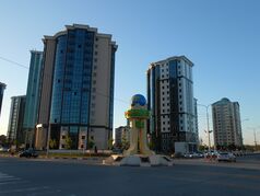
From the top, Central Gudermes, Tashu-Haji Mosque, Entrance to Gudermes | |
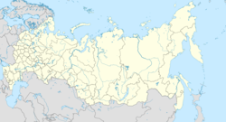
أظهر Location of غوديرميس | |
| الإحداثيات: 43°21′N 46°06′E / 43.350°N 46.100°E | |
| البلد | روسيا |
| الكيان الاتحادي | Chechnya[2] |
| Founded | 1941 |
| المنسوب | 55 m (180 ft) |
| التعداد | |
| • الإجمالي | 45٬631 |
| • Subordinated to | town of republic significance of Gudermes[1] |
| • Capital of | town of republic significance of Gudermes[1], Gudermessky District[1] |
| • Municipal district | Gudermessky Municipal District[4] |
| • Urban settlement | Gudermesskoye Urban Settlement[4] |
| • Capital of | Gudermessky Municipal District[4], Gudermesskoye Urban Settlement[4] |
| منطقة التوقيت | UTC+ ([5]) |
| Postal code(s)[6] | |
| OKTMO ID | 96610101001 |
Gudermes (روسية: Гудерме́с; بالشيشانية: Гуьмсе, Gümse or Гутӏермаӏас, Guthermajas) is a town in the Chechen Republic, Russia, located on the Sunzha River 36 كيلومتر (22 mi) east of Grozny, the republic's capital. Population: 64٬376 (تعداد 2021)؛[7] 45,631 (تعداد 2010);[3] 33,756 (تعداد 2002);[8] 38,089 (تعداد 1989);[9] 32,000 (1970).
التاريخ
Gudermes had rural locality status until 1941. Later, it became a railroad junction between Rostov-on-Don, Baku, Astrakhan, and Mozdok.
المناخ
Gudermes has a humid continental climate (Köppen: Dfa) closely bordering a humid subtropical climate (Köppen: Cfa) . Gudermes is one of the warmest places in Russia and has recorded one of Russia's highest temperatures, recording temperatures as high as 44.0 °C (111.2 °F) in July 1999.[10]
| أخفبيانات المناخ لـ Gudermes, 1991-2020 normals, extremes 1936–الحاضر | |||||||||||||
|---|---|---|---|---|---|---|---|---|---|---|---|---|---|
| الشهر | ينا | فب | مار | أبر | ماي | يون | يول | أغس | سبت | أكت | نوف | ديس | السنة |
| القصوى القياسية °س (°ف) | 17.7 (63.9) |
22.5 (72.5) |
31.7 (89.1) |
33.3 (91.9) |
37.8 (100.0) |
39.7 (103.5) |
41.5 (106.7) |
42.2 (108.0) |
41.0 (105.8) |
32.8 (91.0) |
23.9 (75.0) |
17.9 (64.2) |
42.2 (108.0) |
| متوسط القصوى اليومية °س (°ف) | 2.8 (37.0) |
4.4 (39.9) |
11.1 (52.0) |
18.2 (64.8) |
24.2 (75.6) |
29.4 (84.9) |
32.2 (90.0) |
31.8 (89.2) |
26.0 (78.8) |
18.1 (64.6) |
9.4 (48.9) |
4.3 (39.7) |
17.7 (63.8) |
| المتوسط اليومي °س (°ف) | −0.8 (30.6) |
0.2 (32.4) |
5.5 (41.9) |
11.6 (52.9) |
17.6 (63.7) |
22.7 (72.9) |
25.4 (77.7) |
24.9 (76.8) |
19.5 (67.1) |
12.7 (54.9) |
5.4 (41.7) |
1.0 (33.8) |
12.1 (53.9) |
| متوسط الدنيا اليومية °س (°ف) | −3.4 (25.9) |
−2.8 (27.0) |
1.6 (34.9) |
6.6 (43.9) |
12.5 (54.5) |
17.3 (63.1) |
20.0 (68.0) |
19.4 (66.9) |
14.7 (58.5) |
8.7 (47.7) |
2.5 (36.5) |
−1.6 (29.1) |
8.0 (46.3) |
| الصغرى القياسية °س (°ف) | −29.9 (−21.8) |
−27.4 (−17.3) |
−21.0 (−5.8) |
−5.3 (22.5) |
−1.7 (28.9) |
6.5 (43.7) |
10.1 (50.2) |
6.6 (43.9) |
−1.6 (29.1) |
−9.8 (14.4) |
−22.3 (−8.1) |
−24.5 (−12.1) |
−29.9 (−21.8) |
| متوسط تساقط الأمطار mm (inches) | 32.5 (1.28) |
25.5 (1.00) |
32.9 (1.30) |
36.5 (1.44) |
56.5 (2.22) |
62.9 (2.48) |
43.8 (1.72) |
38.7 (1.52) |
49.3 (1.94) |
39.0 (1.54) |
37.3 (1.47) |
37.5 (1.48) |
492.4 (19.39) |
| Average precipitation days | 7 | 6 | 6 | 5 | 8 | 7 | 6 | 6 | 5 | 7 | 7 | 7 | 77 |
| متوسط الرطوبة النسبية (%) | 85 | 83 | 78 | 72 | 71 | 66 | 63 | 64 | 72 | 80 | 84 | 85 | 75 |
| Source 1: Погода и Климат[11] | |||||||||||||
| Source 2: KNMI (precipitation days),[12] NOAA (humidity)[13] | |||||||||||||
الوضع الإداري والبلدي
Within the framework of administrative divisions, Gudermes serves as the administrative center of Gudermessky District, even though it is not a part of it.[1] As an administrative division, it is incorporated separately as the town of republic significance of Gudermes—an administrative unit with the status equal to that of the districts.[1] As a municipal division, the town of republic significance of Gudermes is incorporated within Gudermessky Municipal District as Gudermesskoye Urban Settlement.[4]
الاقتصاد
Gudermes is home to petroleum extraction industries.
المراجع
Notes
- ^ أ ب ت ث ج ح Decree #500
- ^ Constitution of the Chechen Republic, Article 59.5
- ^ أ ب Russian Federal State Statistics Service (2011). "Всероссийская перепись населения 2010 года. Том 1". Всероссийская перепись населения 2010 года (2010 All-Russia Population Census) (in Russian). Federal State Statistics Service. Retrieved يونيو 29, 2012.
{{cite web}}: Invalid|ref=harv(help); Unknown parameter|trans_title=ignored (|trans-title=suggested) (help)CS1 maint: unrecognized language (link) - ^ أ ب ت ث ج Law #19-RZ
- ^ "Об исчислении времени". Официальный интернет-портал правовой информации (in Russian). يونيو 3, 2011. Retrieved يناير 19, 2019.
{{cite web}}: CS1 maint: unrecognized language (link) - ^ Почта России. Информационно-вычислительный центр ОАСУ РПО. (Russian Post). Поиск объектов почтовой связи (Postal Objects Search) (in روسية)
- ^ invalid reference parameter
- ^ Федеральная служба государственной статистики (Federal State Statistics Service) (مايو 21, 2004). "Численность населения России, субъектов Российской Федерации в составе федеральных округов, районов, городских поселений, сельских населённых пунктов – районных центров и сельских населённых пунктов с населением 3 тысячи и более человек[[Category:Articles containing روسية-language text]] (Population of Russia, its federal districts, federal subjects, districts, urban localities, rural localities—administrative centers, and rural localities with population of over 3,000)". Всероссийская перепись населения 2002 года (All-Russia Population Census of 2002) (in Russian). Federal State Statistics Service. Retrieved يوليو 25, 2008.
{{cite web}}: URL–wikilink conflict (help)CS1 maint: unrecognized language (link) - ^ "Всесоюзная перепись населения 1989 г. Численность наличного населения союзных и автономных республик, автономных областей и округов, краёв, областей, районов, городских поселений и сёл-райцентров.[[Category:Articles containing روسية-language text]] (All Union Population Census of 1989. Present population of union and autonomous republics, autonomous oblasts and okrugs, krais, oblasts, districts, urban settlements, and villages serving as district administrative centers.)". Всесоюзная перепись населения 1989 года (All-Union Population Census of 1989) (in Russian). Demoscope Weekly (website of the Institute of Demographics of the State University—Higher School of Economics. 1989. Retrieved ديسمبر 13, 2007.
{{cite web}}: Italic or bold markup not allowed in:|publisher=(help); URL–wikilink conflict (help)CS1 maint: unrecognized language (link) - ^ "July 1999". Eca.knmi.nl. Retrieved فبراير 15, 2019.
- ^ "Climate Gudermes". Погода и Климат. Retrieved ديسمبر 25, 2020.
- ^ "Indices Data – Gudermes Station 1380". KNMI. Archived from the original on يوليو 9, 2018. Retrieved مايو 14, 2019.
- ^ "World Meteorological Organization Climate Normals for 1991-2020 — Gudermes". National Oceanic and Atmospheric Administration. Retrieved أبريل 9, 2024.
المصادر
- Pages using gadget WikiMiniAtlas
- CS1 errors: unsupported parameter
- Articles with روسية-language sources (ru)
- Articles containing روسية-language text
- CS1 errors: URL–wikilink conflict
- CS1 errors: markup
- Short description is different from Wikidata
- Pages using multiple image with auto scaled images
- Infobox mapframe without OSM relation ID on Wikidata
- Coordinates on Wikidata
- Pages using infobox settlement with image map1 but not image map
- Russian inhabited locality articles requiring maintenance
- Pages using Lang-xx templates
- Articles containing چچن-language text
- Use mdy dates from October 2012
- Cities and towns in Chechnya
- صفحات مع الخرائط


