إيمان غنيم
ايمان غنيم | |
|---|---|
 | |
| المدرسة الأم | جامعة طنطا |
| السيرة العلمية | |
| المجالات | جيومورفولوجيا |
| أطروحة | توصيف إمكانية حدوث الفيضانات في منطقة ساحل البحر الأحمر القاحلة في مصر. |
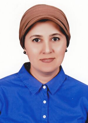
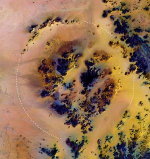
إيمان غنيم هي عالمة جيومورفولوجيا مصرية أمريكية. في مارس 2006، اكتشفت الدكتورة إيمان غنيم مع فاروق الباز الفوهة الكبيرة، وهي فوهة ارتطام ( نجمي) في الصحراء.[1] في عام 2007، أثناء معالجة بيانات فضاء الموجات الصغرية ( صور الرادار)، اكتشفت بحيرة ضخمة قديمة (30750 كيلومترًا مربعًا) مدفونة تحت رمال الصحراء الكبرى في شمال دارفور، السودان.[2]
الحياة المهنية والبحث
تخرجت إيمان غنيم بدرجة الشرف وحصلت على درجة الماجستير من قسم الجغرافيا في جامعة طنطا، مصر في عام 1997. حصلت على درجة الدكتوراه في الجغرافيا من قسم الجغرافيا في جامعة ساوثهامبتون، بالمملكة المتحدة عام 2002.[3] في عام 2003، شغلت منصب ما بعد الدكتوراه في مركز الاستشعار عن بعد، جامعة بوسطن، الولايات المتحدة. خلال هذا الوقت ساعدت في اكتشاف الفوهة الكبيرة. في عام 2010، انضمت إلى قسم علوم الأرض والمحيطات في جامعة نورث كارولينا ويلمنجتون (UNCW) وأصبحت مديرة مختبر الاستشعار عن بُعد للفضاء والطائرات بدون طيار (SDRS).
لديها تركيز أساسي على تطبيق نظام المعلومات الجغرافية (GIS)، والاستشعار عن بعد (بما في ذلك صور الرادار متعددة الأطياف والحرارية والموجات الصغرية)، والمركبات الجوية غير المأهولة (الطائرات بدون طيار) واستخدام النمذجة الهيدرولوجية في مخاطر الفيضانات المفاجئة، وارتفاع مستوى سطح البحر، والجفاف واستكشاف المياه الجوفية في البيئات القاحلة والساحلية.[4]
إيمان غنيم خبيرة في معالجة الصور وتستخدم مجموعة واسعة من بيانات الأقمار الصناعية / الفضائية بما في ذلك الأشعة تحت الحمراء متعددة الأطياف، الفائقة الطيفية (TIR)، والموجات الصغرية (صور الرادار) و نموذج الارتفاع الرقمي (DEM). نشرت إيمان غنيم أكثر من 27 ورقة علمية محكمة. نشرت أكثر من 48 مقالاً في المؤتمرات وقدمت عددًا من ورش العمل ومحاضرات الندوات والدورات التدريبية للمندوبين متعددي التخصصات.[بحاجة لمصدر]
تمت دعوة إيمان غنيم كخبيرة في مجالها، إلى جانب 30 امرأة مصرية مغتربة، للمشاركة في مؤتمر Taa Marbouta في عام 2017. وقد تم تنظيم المؤتمر، الذي ركز على أهمية المرأة المصرية في المجالات الاجتماعية والسياسية والاقتصادية، من قبل وزارة الهجرة وشؤون المغتربين المصريين والمجلس القومي للمرأة.[5]
بالإضافة إلى عملها البحثي، كانت إيمان غنيم تقوم بالتدريس في التعليم العالي منذ عام 1990.[3] تقديراً لعملها التدريسي، حصلت على العديد من الجوائز، بما في ذلك جائزة مجلس الأمناء للتميز في التدريس بجامعة نورث كارولينا ويلمنجتون في عام 2018.[6]
الجوائز والتكريم
- جائزة مجلس محافظي جامعة الأمم المتحدة للتميز في التدريس (2021)
- جائزة مجلس الأمناء للتميز في التدريس، جامعة نورث كارولينا ويلمنجتون (2018)[6]
- جائزة أستاذ التدريس المتميز، جامعة نورث كارولينا ويلمنجتون[6]
- جائزة المستشار المتميز في التدريس ، جامعة نورث كارولينا ويلمنجتون (2017) [7]
- جائزة "المرأة المصرية تستطيع" (2017)[7]
- القيادات النسائية في العلوم والتكنولوجيا والهندسة والرياضيات[6]
- جائزة أفضل رسالة من جمعية الاستشعار عن بعد والمسح التصويري في المملكة المتحدة عن البحث "أكبر شكل فوهة في الصحراء الكبرى تم الكشف عنه من خلال الصور متعددة الأطياف وبيانات الرادار"[8]
منشورات مختارة
- Fahil, A.S, Ghoneim, E., Noweir, M.A., Masoud, A. 2020. Integration of Well Logging and Remote Sensing Data for Detecting Potential Geothermal Sites along the Gulf of Suez, Egypt. Resources 9, 109
- Ghoneim, E., El-Baz, F., 2020. Satellite image data integration for groundwater exploration in Egypt. In: Elbeih S., Negm A., Kostianoy A (edit), Egypt Environment: a Satellite Remote Sensing Approach. Springer. Chapter 8. 211–230.
- Bratley, K., Ghoneim, E. 2018. Modeling Urban Encroachment on the Agricultural Land of the Eastern Nile Delta Using Remote Sensing and GIS-based Markov Chain Model. Land 7(4), 114.
- Mashaly, J., Ghoneim, E. 2018. Flash Flood Hazard Using Optical, Radar, and Stereo-Pair Derived DEM: Eastern Desert, Egypt. Remote Sensing. 10(8), 1204. (Special Issue)
- Ghoneim, E. 2018. Rimaal: A Sand Buried Structure of Possible Impact Origin in the Sahara: Optical and Radar Remote Sensing Investigation. Remote Sensing 10 (6), 880.
- Abrams, W., Ghoneim, E., Shew, R., LaMaskin, T., Al Bloushi, K., Hussein, S., AbuBakr, M., Almulla, A., Al-Awar, M., El-Baz, F. 2018. Delineation of Groundwater Potential in the northern United Arab Emirates and Oman using geospatial technologies in conjunction with SAW, AHP and PFR techniques. Journal of Arid Environment, 157: 77–96.
- El-Behaedi, R., Ghoneim, E. 2018. Flood Risk Assessment of the Abu Simbel Temple Complex (Egypt) based on High-Resolution Spaceborne Stereo Imagery. Journal of Archaeological Science: Reports 20: 458–467.
- Ghoneim, E., Dorofeeva, A., Benedetti, M., Gamble, G., Leonard, L., AbuBakr, M. 2017. Vegetation Drought Analysis in Tunisia: A Geospatial Investigation. Journal of Atmospheric and Earth Sciences 1(1-002), 1–9.
- Robinson, C., El-Kaliouby, H., Ghoneim, E. 2017. Influence of Structures on Drainage Patterns in the Tushka Region, SW Egypt. Journal of African Earth Sciences, 136: 262–271. (Special Issue)
- Aljenaid, S., Ghoneim, E., Abido, M., AlWedhai, K., Khadim, G., Mansoor, S., EL-Deen, W., Abd Hameed, N. 2017. Integrating Remote Sensing and Field Survey to Map Shallow Water Benthic Habitat for the Kingdom of Bahrain. Journal of Environmental Science and Engineering B 6: 176–200.
- Sosnowski, A., Ghoneim, E., Burke, J. J., Hines, E., Halls, J. 2016. Remote regions, remote data: A spatial investigation of precipitation, dynamic land covers, and conflict in the Sudd wetland of South Sudan. Applied Geography, 69: 51–64.
- Rogers, S., Benford, E., Kennedy, A., Austin M., and Ghoneim, E. 2015. Building Damage Analysis following Hurricane Ike on the Bolivar Peninsula, TX. Proc., Coastal structures and solutions to coastal disasters 2015: resilient coastal communities. American Society of Civil Engineers (ASCE), 161–171.
- Ghoneim E., Mashaly, J., Gamble, D., Halls, J., AbuBakr, M. 2015. The use of automated shorelines to assess the response of pre- and post-beach protection and projected shoreline change in the Rosetta Promontory, Nile Delta. Geomorphology, 228, 1–14.
- Ghoneim, E., Foody, G. 2013. Assessing flash flood hazard in an arid mountainous region. Arabian Journal of Geosciences 6 (4): 1191–1202.
- AbuBakr, M., Ghoneim, E., El-Baz, F., Zeneldin, M., Zeid, S. 2013. Use of radar data to unveil the paleolakes and the ancestral course of Wadi El-Arish, Sinai Peninsula, Egypt. Geomorphology, 194, 34–45.
- Abdelkareem, M., Ghoneim, E., El-Baz., F., Askawy, A. 2012. New Insight on Paleoriver Development in the Eastern Sahara. Journal of African Earth Sciences, 62 (1): 35 - 40.
- Abdelkareem, M., El-Baz, F. Askalawy, M., Askawy, A., Ghoneim, E. 2012. Groundwater Prospect map of Egypt's Qena Valley using data fusion. International Journal of Image and Data Fusion 3(2): 169 – 189.
- Ghoneim, E., Benedetti, M., El-Baz, F. 2012. An Integrated Remote Sensing and GIS Analysis of the Kufrah Paleoriver, Eastern Sahara, Libya. Geomorphology, 139: 242 – 257.
- Shaban, A., Hamzé, M., El-Baz, F., Ghoneim, E. 2009. Characterization of oil spill along the Lebanese coast by remote sensing. Environmental Forensics Journal, 10 (1): 51–59.
- Gaber, A., Ghoneim, E., Khalaf, F., El-Baz, F. 2009. Delineation of Paleolakes in Arid Regions Using Remote Sensing and GIS. Journal of Arid Environments, 73: 127–134.
- Ghoneim, E. Ibn-Batutah: 2009. A possible simple impact structure in southeastern Libya. Geomorphology, 103 (3): 340–350.
- Ghoneim, E. 2009. A Remote Sensing Study of Some Impacts of Global Warming on the Arab Region. In: Tolba, M and Saab, N. (edit), Report on Arab Environment: Climate Change, The Arab Forum for Environment and Development, Chapter 3: 31–46.
- Ghoneim, E. 2008. Optimum groundwater locations in the Northern United Arab Emirates. International Journal of Remote Sensing, 29 (20): 5879–5906.
- Ghoneim, E., El-Baz F. 2008. Mapping water basins in the Eastern Sahara by SRTM data. IEEE 1: 1- 4.
- Ghoneim, E., Robinson, C., El-Baz, F. 2007. Relics of ancient drainage in the eastern Sahara revealed by radar topography data. International Journal of Remote Sensing, 28 (8): 1759–1772.
- El-Baz, F., Ghoneim, E. 2007. Largest crater in the Great Sahara revealed by multi-spectral images and radar data. International Journal of Remote Sensing, 28 (2): 451–458. (2007 Best Letter Award by RSPS).
- Ghoneim, E., El-Baz, F. 2007 The application of radar topographic data to mapping of a mega-paleodrainage in the Eastern Sahara. Journal of Arid Environments, 69: 658–675.
- Ghoneim, E., El-Baz, F. 2007. Dem-optical-radar data integration for paleo- hydrological mapping in the northern Darfur, Sudan: Implication for groundwater exploration. International Journal of Remote Sensing, 28 (22): 5001–5018.
- Shaban, A., Ghoneim, E., Hamzé, M., El-Baz, F. 2007. A post-conflict assessment to characterize the oil spill off-shore Lebanon by using remote sensing. Lebanese Science Journal, 8 (2), 75–85.
- El-Baz, F., Ghoneim, E. 2006. Veiled crater in the eastern Sahara. The Planetary Report; XXVI (4): 10–15.
- Foody, G., Ghoneim, E. Arnell, N. 2004. Predicting locations sensitive to flash flooding in an arid environment. Journal of Hydrology, 292: 48–58.
- Ghoneim, E., Arnell, N., Foody, G. 2002. Characterizing the flash flood hazards potential along the Red Sea coast of Egypt. The Extremes of the Extremes: Extraordinary Floods. IAHS Publ, 271: 211- 216.
انظر أيضاً
المصادر
- ^ "Largest Crater In The Great Sahara Discovered By Boston University Scientists". 2006-04-12. Archived from the original on 2006-04-12. Retrieved 2018-11-20.
- ^ Brahic, Catherine (12 April 2007). "Ancient mega-lake discovered in Darfur". New Scientist. Retrieved 31 December 2012.
- ^ أ ب "Department of Geography and Geology: Dr. Eman Ghoneim". people.uncw.edu. Retrieved 2019-03-31.
- ^ "Dr. Eman Ghoneim, Center for Remote Sensing". Boston University. Archived from the original on 2011-04-14. Retrieved 2014-07-24.
- ^ "31 Egyptian female expatriates participate in Cairo conference". Egypt Independent. 2017-07-02. Retrieved 2019-03-31.
- ^ أ ب ت ث "Honor Roll: Excellence Rewarded at Annual Faculty Awards". uncw.edu (in الإنجليزية). Retrieved 2019-03-31.
- ^ أ ب "Associate Professor Eman Ghoneim Receives Egyptian Presidential Invitation to "Egyptian Women Can" Conference". uncw.edu (in الإنجليزية). Retrieved 2019-03-31.
- ^ "Honors". Eos, Transactions American Geophysical Union (in الإنجليزية). 89 (39): 363. 2008-09-23. doi:10.1029/EO089i039p00363-03.
