ڤلاديچين خان
ڤلاديچين خان
Владичин Хан Vladičin Han | |
|---|---|
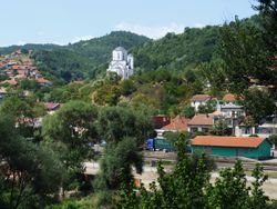
 General view | |
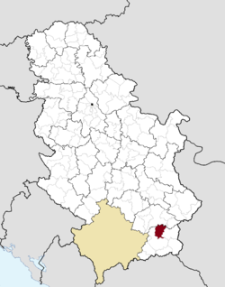
 Location of the municipality of Vladičin Han within Serbia | |
| الإحداثيات: 42°42′N 22°04′E / 42.700°N 22.067°E | |
| البلد | |
| المنطقة | جنوب وشرق صربيا |
| المحافظة | پچينيا |
| التجمعات السكنية | 51 |
| الحكومة | |
| • العمدة | Nenad Mitrović |
| المساحة | |
| • Town | 4٫30 كم² (1٫66 ميل²) |
| • Municipality | 366 كم² (141 ميل²) |
| المنسوب | 386 m (1٬266 ft) |
| التعداد (2011 census)[2] | |
| • Town | 8٬053 |
| • كثافة Town | 1٬900/km2 (4٬900/sq mi) |
| • Municipality | 20٬938 |
| • كثافة Municipality | 57/km2 (150/sq mi) |
| منطقة التوقيت | UTC+1 (CET) |
| • الصيف (التوقيت الصيفي) | UTC+2 (CEST) |
| Postal code | 17510 |
| Area code | +381(0)17 |
| Car plates | VR |
| الموقع الإلكتروني | www |
ڤلاديچين خان (سيريلية صربية: Владичин Хан, تـُنطق [ʋlǎdit͡ʃiŋ xâːn])[3] هي بلدة وبلدية في محافظة پچينيا بجنوب صربيا.
يبلغ عدد سكانها حوالي 8536 نسمة.
. . . . . . . . . . . . . . . . . . . . . . . . . . . . . . . . . . . . . . . . . . . . . . . . . . . . . . . . . . . . . . . . . . . . . . . . . . . . . . . . . . . . . . . . . . . . . . . . . . . . . . . . . . . . . . . . . . . . . . . . . . . . . . . . . . . . . . . . . . . . . . . . . . . . . . . . . . . . . . . . . . . . . . . .
التاريخ
من 1929 إلى 1941، كانت ڤلاديچين خان جزءاً من پانوڤينا ڤاردار في مملكة يوغسلاڤيا.
التجمعات السكنية
بجانب بلدة ڤلاديچين خان، فإن البلدية تضم التجمعات التالية:
- Balinovce
- Bačvište
- Belanovce
- Beliševo
- Bogoševo
- Brestovo
- ڤربوڤو
- Garinje
- Gornje Jabukovo
- Gramađe
- Dekutince
- Donje Jabukovo
- Dupljane
- Žitorađe
- Zebince
- Jagnjilo
- Jastrebac
- يوڤاتس
- Kalimance
- Kacapun
- Koznica
- Kopitarce
- Kostomlatica
- Kržince
- Kukavica
- Kunovo
- Lebet
- Lepenica
- Letovište
- Ljutež
- Mazarać
- Manajle
- Manjak
- Mrtvica
- Ostrovica
- Polom
- Prekodolce
- Priboj
- Ravna Reka
- Rdovo
- Repince
- Repište
- Ružić
- Solačka Sena
- Srneći Dol
- Stubal
- Suva Morava
- Tegovište
- Urvič
- Džep
الديمغرافيا
| Year | Pop. | ±% p.a. |
|---|---|---|
| 1948 | 24٬946 | — |
| 1953 | 25٬927 | +0.77% |
| 1961 | 26٬074 | +0.07% |
| 1971 | 25٬231 | −0.33% |
| 1981 | 25٬441 | +0.08% |
| 1991 | 25٬225 | −0.09% |
| 2002 | 23٬703 | −0.56% |
| 2011 | 20٬871 | −1.40% |
| Source: [4] | ||
According to the 2011 census results, the municipality of Vladičin Han has a population of 20,871 inhabitants.
الجماعات العرقية
The ethnic composition of the municipality:[5]
| الجماعة العرقية | التعداد |
|---|---|
| الصرب | 18,644 |
| الغجر | 1,503 |
| البلغار | 88 |
| المقدون | 23 |
| الروس | 10 |
| Others | 603 |
| الإجمالي | 20,871 |
معرض صور
انظر أيضاً
المراجع
- ^ قالب:Serbian municipalities 2006
- ^ قالب:Serbian census 2011
- ^ Vladičin / Владичин pronounced in isolation: [ʋlǎdit͡ʃin].
- ^ "2011 Census of Population, Households and Dwellings in the Republic of Serbia" (PDF). stat.gov.rs. Statistical Office of the Republic of Serbia. Retrieved 11 January 2017.
- ^ "Попис становништва, домаћинстава и станова 2011. у Републици Србији" (PDF). stat.gov.rs. Republički zavod za statistiku. Retrieved 15 January 2017.
وصلات خارجية
| Vladičin Han
]].


