پيلبرا
پيلبرا Pilbara ( /ˈpɪlbərə/)، هي منطقة شاسعة، جافة، ذات عدد محدود من السكان في شمال أستراليا. تشتهر بشعوبها الأصلية؛ مناظرها الطبيعية القديمة؛ أرضها الحمراء؛ وودائعها الغنية بالمعادن، وبصفة خاص خام الحديد. كما تعتبر مركزاً للتنوع الحيوي العالمي subterranean fauna.[1]
تعريفات منطقة پيلبرا
| مناطق IBRA والمناطق الفرعية: IBRA7 | ||||||
|---|---|---|---|---|---|---|
| مناطق IBRA/ المناطق الفرعية | IBRA code | المساحة | الولاية | الموقع في أستراليا | ||
| پيلبرا | PIL | 17,823,126 hectares (44,041,900 acres) | WA | 
| ||
| Chichester | PIL01 | 8,374,728 hectares (20,694,400 acres) | ||||
| Fortescue | PIL02 | 1,951,435 hectares (4,822,100 acres) | ||||
| Hamersley | PIL03 | 5,634,727 hectares (13,923,710 acres) | ||||
| Roebourne | PIL04 | 1,862,236 hectares (4,601,690 acres) | ||||
الحكومة المحلية
الحكومة المحلية الحالية في پيلبرا:
- Ashburton – Shire of Ashburton
- East Pilbara – Shire of East Pilbara
- Karratha – City of Karratha
- Port Hedland – Town of Port Hedland
التسمية
التاريخ

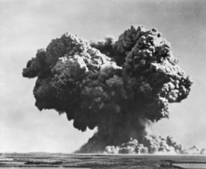
سحابة عيش الغراب ناجمة عن تفجيرات العملية هوريكان.
الشعوب الأصلية
الجغرافيا
الموقع والوصف

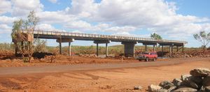
300m of North West Coastal Highway approaches to the Maitland River bridge were destroyed during Cyclone Monty
المناخ

The Terra satellite captured this image of Cyclone Fay, over the Western Australian coast on 27 March 2004.
| Climate data for پورت هدلاند (الساحل) | |||||||||||||
|---|---|---|---|---|---|---|---|---|---|---|---|---|---|
| Month | Jan | Feb | Mar | Apr | May | Jun | Jul | Aug | Sep | Oct | Nov | Dec | Year |
| Record high °C (°F) | 49.0 (120.2) |
48.2 (118.8) |
45.9 (114.6) |
42.4 (108.3) |
38.8 (101.8) |
35.5 (95.9) |
34.4 (93.9) |
36.8 (98.2) |
42.2 (108.0) |
46.9 (116.4) |
47.4 (117.3) |
47.9 (118.2) |
49.0 (120.2) |
| Mean daily maximum °C (°F) | 36.4 (97.5) |
36.2 (97.2) |
36.7 (98.1) |
35.2 (95.4) |
30.6 (87.1) |
27.6 (81.7) |
27.1 (80.8) |
29.2 (84.6) |
32.3 (90.1) |
34.8 (94.6) |
36.2 (97.2) |
36.6 (97.9) |
33.2 (91.8) |
| Mean daily minimum °C (°F) | 25.6 (78.1) |
25.5 (77.9) |
24.5 (76.1) |
21.4 (70.5) |
17.2 (63.0) |
14.1 (57.4) |
12.3 (54.1) |
13.1 (55.6) |
15.4 (59.7) |
18.4 (65.1) |
21.3 (70.3) |
24.0 (75.2) |
19.4 (66.9) |
| Record low °C (°F) | 18.1 (64.6) |
16.3 (61.3) |
15.8 (60.4) |
12.2 (54.0) |
7.0 (44.6) |
4.7 (40.5) |
3.2 (37.8) |
3.7 (38.7) |
7.7 (45.9) |
11.1 (52.0) |
12.4 (54.3) |
16.6 (61.9) |
3.2 (37.8) |
| Average rainfall mm (inches) | 62.2 (2.45) |
94.8 (3.73) |
50.1 (1.97) |
22.4 (0.88) |
27.0 (1.06) |
20.7 (0.81) |
11.1 (0.44) |
4.9 (0.19) |
1.3 (0.05) |
0.9 (0.04) |
2.7 (0.11) |
17.9 (0.70) |
314.4 (12.38) |
| Source: مكتب الأرصاد الجوية[2] | |||||||||||||
| Climate data for نيومان (الأراضي الداخلية) | |||||||||||||
|---|---|---|---|---|---|---|---|---|---|---|---|---|---|
| Month | Jan | Feb | Mar | Apr | May | Jun | Jul | Aug | Sep | Oct | Nov | Dec | Year |
| Record high °C (°F) | 47.0 (116.6) |
46.0 (114.8) |
43.3 (109.9) |
40.4 (104.7) |
35.2 (95.4) |
33.0 (91.4) |
31.0 (87.8) |
34.1 (93.4) |
38.0 (100.4) |
42.9 (109.2) |
43.9 (111.0) |
45.0 (113.0) |
47.0 (116.6) |
| Mean daily maximum °C (°F) | 39.5 (103.1) |
37.2 (99.0) |
35.8 (96.4) |
31.6 (88.9) |
27.3 (81.1) |
22.9 (73.2) |
23.0 (73.4) |
25.8 (78.4) |
30.5 (86.9) |
35.0 (95.0) |
37.4 (99.3) |
38.9 (102.0) |
32.1 (89.8) |
| Mean daily minimum °C (°F) | 25.3 (77.5) |
24.4 (75.9) |
22.4 (72.3) |
18.4 (65.1) |
13.0 (55.4) |
9.6 (49.3) |
8.1 (46.6) |
10.1 (50.2) |
13.7 (56.7) |
17.9 (64.2) |
21.4 (70.5) |
23.9 (75.0) |
17.3 (63.1) |
| Record low °C (°F) | 16.1 (61.0) |
17.0 (62.6) |
9.0 (48.2) |
6.0 (42.8) |
1.0 (33.8) |
−1.1 (30.0) |
−2.0 (28.4) |
−2.0 (28.4) |
1.0 (33.8) |
6.0 (42.8) |
11.8 (53.2) |
15.2 (59.4) |
−2.0 (28.4) |
| Average precipitation mm (inches) | 57.2 (2.25) |
78.9 (3.11) |
41.7 (1.64) |
18.4 (0.72) |
18.5 (0.73) |
14.6 (0.57) |
15.1 (0.59) |
7.7 (0.30) |
3.4 (0.13) |
4.7 (0.19) |
10.5 (0.41) |
37.4 (1.47) |
312.0 (12.28) |
| Source: [3] | |||||||||||||
الاقتصاد
الحديد الخام
الغاز الطبيعي المسال
الزراعة

Millstream Homestead in Millstream-Chichester National Park
النقل
الموانئ
- Port Hedland
- Nelson Point and Finucane Island (operated by BHP)
- Herb Elliott Port (operated by the Fortescue Metals Group)
- Dampier (operated by Rio Tinto)
- Cape Lambert (operated by Rio Tinto)
- Anketell Port (under development)
علم البيئة

The vibrant colours of the outback in Karijini National Park
انظر أيضاً
- متكون الحديد الشريطي (BIF)
- شمال غرب أستراليا
- ساحل پيلبرا
- خط زمني لتاريخ پيلبرا
- صحف پيلبرا
- سكك حديد پيلبرا
المصادر
- ^ S.A. Halse; M.D. Scanlon; J.S. Cocking; H.J. Barron; J.B. Richardson; S.M. Eberhard (2014). "Pilbara stygofauna: deep groundwater of an arid landscape contains globally significant radiation of biodiversity" (PDF). Records of the Western Australian Museum. Supplement 78: 443–483.
- ^ "Climate statistics". Retrieved 3 January 2013.
- ^ "BOM".
- "IBRA7: Pilbara Bioregion (PIL" (PDF). Retrieved 20 April 2018.
- "IBRA7: Pilbara subregions (PIL01-PIL04" (PDF). Retrieved 20 April 2018.
قراءات إضافية
- Ellem, Braden (2017). The Pilbara: From the Deserts Profits Come. Crawley, WA: UWA Publishing. ISBN 9781742589305.
- Sharp, Janet, and Nicholas Thieberger. (1992). Aboriginal languages of the Pilbara Region: Bilybara. Wangka Maya Pilbara Aboriginal Language Centre, Port Hedland, WA.
وصلات خارجية
Wikivoyage has a travel guide for Pilbara.
- Pilbara Development Commission
- NASA-Macquarie University Pilbara Education Project
- Olive Python captive breeding program
- Wattles of the Pilbara
- Yamatji Marlpa Barna Baba Maaja Aboriginal Corporation, the Native Title Representative Body incorporating the Pilbara Native Title Service
الكلمات الدالة:


