وُرِك
| Warwick | |
|---|---|
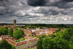
 A view over Warwick | |
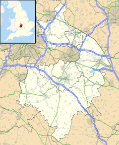
Location within Warwickshire | |
| Population | 31٬345 |
| OS grid reference | SP2865 |
| Civil parish |
|
| District | |
| Shire county | |
| Region | |
| Country | England |
| Sovereign state | United Kingdom |
| Post town | WARWICK |
| Postcode district | CV34, CV35 |
| Dialling code | 01926 |
| Police | Warwickshire |
| Fire | Warwickshire |
| Ambulance | West Midlands |
| EU Parliament | West Midlands |
| UK Parliament | |
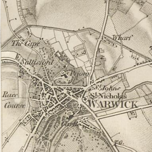
وُرِك (Warwick ؛ /ˈwɒrɪk/ ؛ WOR-ik) هي بلدة سوق و بلدة مقاطعة في Warwickshire، إنگلترة. It lies near the River Avon, 11 ميل (18 km) south of Coventry and west of Leamington Spa and Whitnash. Its population was 31,345 in 2011. Signs of Neolithic activity precede unbroken habitation to the 6th century AD. It was a Saxon burh in the 9th century; Warwick Castle was built during the Norman conquest of England. Warwick School claims to be the country's oldest boys' school. The earldom of Warwick, created in 1088, controlled the town and built its walls, of which Eastgate and Westgate survive. The castle became a fortress, then a mansion. The Great Fire of Warwick in 1694 destroyed much of the town. Warwick missed industrialisation, but the population has grown almost sixfold since 1801.
التاريخ


The name Warwick means "dwellings by the weir".[1]
الجغرافيا
المناخ
Warwick experiences the usual English maritime climate, marked by a narrow temperature range, mild winters and cool summers. The nearest official Met Office weather station is at Wellesbourne, about 6 miles (10 km) south of the town centre and at a similar elevation.
The absolute maximum temperature (also the absolute maximum for the county of Warwickshire) stands at 36.1 °C (97.0 °F)[2] recorded in August 1990. During a typical year, the warmest day should reach 30.0 °C (86.0 °F),[3] and 16.5 days[4] should report a maximum of 25.1 °C (77.2 °F) or higher.
The lowest recorded temperature is −17.8 °C (0.0 °F),[5] recorded in January 1982. Typically, 53.3 air frosts are recorded in an "average" year.
Rainfall averages out at 608 ميليمتر (23.9 in) per year,[6] with over 114 days[7] seeing 1 mm (0.04 in) or more falling. All averages refer to the 1971–2000 period.
| بيانات المناخ لـ ولزبورن، ارتفاع 47 متر، 1971–2000، القصوى 1960– | |||||||||||||
|---|---|---|---|---|---|---|---|---|---|---|---|---|---|
| الشهر | ينا | فب | مار | أبر | ماي | يون | يول | أغس | سبت | أكت | نوف | ديس | السنة |
| القصوى القياسية °س (°ف) | 14.5 (58.1) |
17.8 (64.0) |
21.7 (71.1) |
26.3 (79.3) |
28.1 (82.6) |
32.8 (91.0) |
35.4 (95.7) |
36.1 (97.0) |
28.9 (84.0) |
23.9 (75.0) |
18.8 (65.8) |
15.6 (60.1) |
36.1 (97.0) |
| متوسط القصوى اليومية °س (°ف) | 7.0 (44.6) |
7.5 (45.5) |
10.2 (50.4) |
12.8 (55.0) |
16.5 (61.7) |
19.4 (66.9) |
22.4 (72.3) |
21.9 (71.4) |
18.4 (65.1) |
14.1 (57.4) |
9.8 (49.6) |
7.7 (45.9) |
14.0 (57.2) |
| متوسط الدنيا اليومية °س (°ف) | 0.9 (33.6) |
0.8 (33.4) |
2.4 (36.3) |
3.6 (38.5) |
6.2 (43.2) |
9.1 (48.4) |
11.3 (52.3) |
11.2 (52.2) |
9.3 (48.7) |
6.5 (43.7) |
3.2 (37.8) |
1.7 (35.1) |
5.5 (41.9) |
| الصغرى القياسية °س (°ف) | −17.8 (0.0) |
−14.5 (5.9) |
−10 (14) |
−6.6 (20.1) |
−2.8 (27.0) |
−1.7 (28.9) |
2.2 (36.0) |
1.7 (35.1) |
−2.2 (28.0) |
−5.7 (21.7) |
−8.5 (16.7) |
−17.4 (0.7) |
−17.8 (0.0) |
| متوسط تساقط الأمطار mm (inches) | 53.84 (2.12) |
39.86 (1.57) |
45.27 (1.78) |
44.86 (1.77) |
49.3 (1.94) |
53.57 (2.11) |
44.75 (1.76) |
56.32 (2.22) |
57.58 (2.27) |
54.97 (2.16) |
50.18 (1.98) |
57.77 (2.27) |
608.46 (23.96) |
| Source: KNMI[8] | |||||||||||||
الديمغرافيا
| Warwick[9] | Warwick District[10] |
England | |
|---|---|---|---|
| Total population | 23,350 | 125,931 | 49,138,831 |
| White | 93.9% | 92.9% | 90.9% |
| Asian | 3.8% | 4.7% | 4.6% |
| Black | 0.4% | 0.5% | 2.3% |
بلدات توأم
The town of Warwick has formal twinning arrangements with two European towns: Saumur in France (since 1976) and Verden in Germany (since 1989). Havelberg in Germany has been a friendship town since 1990 when it was adopted by Verden.[11] There is also a friendship link with Bo District in Sierra Leone.[12]
المراجع
- الهامش
- ^ Warwickshire History, Warwickshire County Council, Archived from the original on 1 October 2011, http://webarchive.nationalarchives.gov.uk/20111001050225/http://www.warwickshire.gov.uk/web/corporate/pages.nsf/Links/25EE23195BF64DF4802570280032DF5C, retrieved on 2 April 2011
- ^ "1990 maximum". Retrieved 28 February 2011.
- ^ "Annual average maximum". Retrieved 28 February 2011.
- ^ "Days >25c average". Retrieved 28 February 2011.
- ^ "1982 minimum". Retrieved 28 February 2011.
- ^ "1971-00 Rainfall". Retrieved 28 February 2011.
- ^ "1971-00 Raindays". Retrieved 28 February 2011.
- ^ "Climate Normals 1971–2000". KNMI. Retrieved 28 February 2011.
- ^ KS06 Ethnic group: Census 2001, Key Statistics for urban areas, Statistics.gov.uk, 25 January 2005, Archived from the original on 4 August 2009, https://web.archive.org/web/20090804211441/http://www.statistics.gov.uk/statbase/ssdataset.asp?vlnk=8283&More=Y, retrieved on 2 April 2011
- ^ Warwick (Local Authority) ethnic group, Statistics.gov.uk, http://neighbourhood.statistics.gov.uk/dissemination/LeadTableView.do?a=7&b=277133&c=Warwick&d=13&e=16&g=494401&i=1001x1003x1004&o=1&m=0&r=1&s=1301771431156&enc=1&dsFamilyId=87, retrieved on 2 April 2011
- ^ Twinning, Warwick District Council, Archived from the original on 20 October 2013, https://web.archive.org/web/20131020235146/http://www.warwickdc.gov.uk/WDC/Leisure/Tourism%2Band%2Btravel/Twinning/, retrieved on 3 April 2011
- ^ One World Link, One World Link, http://www.oneworldlink.org.uk/, retrieved on 3 April 2011
- ببليوگرافيا
- Allen, Geoff (2000), Warwickshire Towns & Villages, Sigma Leisure, ISBN 1-85058-642-X
- Allison, K. J.; Dunning, R. W.; Jones, S. R. (1969), "The Borough of Warwick: Introduction", in Stephens, W. B., A History of the County of Warwick: Volume 8: The City of Coventry and Borough of Warwick, Victoria County History, pp. 417–451, ISBN 0-19-722734-1
- Harfield, C. G. (1991), "A Hand-list of Castles Recorded in the Domesday Book", English Historical Review 106: 371–392, doi:
- Pevsner, Nikolaus; Wedgwood, Alexandra (1996) [1966], Warwickshire, The Buildings of England, Penguin Books, ISBN 0-14-071031-0
- Slater, Terry (1981), A History of Warwickshire, Phillimore, ISBN 0-85033-416-0, https://archive.org/details/historyofwarwick00slat
للاستزادة
- Allison, K. J. (1969a), "The Borough of Warwick: Political and Administrative History to 1545", in Stephens, W. B., A History of the County of Warwick: Volume 8: The City of Coventry and Borough of Warwick, Victoria County History, pp. 476–480, ISBN 0-19-722734-1
- Allison, K. J. (1969b), "The Borough of Warwick: Economic and Social History to 1545", in Stephens, W. B., A History of the County of Warwick: Volume 8: The City of Coventry and Borough of Warwick, Victoria County History, pp. 480–489, ISBN 0-19-722734-1
