هاپيسبرگ
| هاپيسبرگ | |
|---|---|
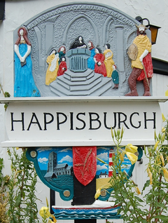 لافتة قرية هاپيسبرگ | |
| Area | 9.63 km2 (3.72 sq mi) |
| Population | 889 ONS and Norfolk CC 2011 census[1][2] |
| • Density | 92/km2 (240/sq mi) |
| OS grid reference | TG 39 31 |
| • London | 220 كم |
| Civil parish |
|
| District | |
| Shire county | |
| Country | إنگلترة |
| Sovereign state | United Kingdom |
| Post town | NORWICH |
| Postcode district | NR12 |
| Dialling code | 01692 |
| Police | |
| Fire | |
| Ambulance | |
| UK Parliament | |
هاپيسبرگ Happisburgh (/ˈheɪz.bʌrə/ (![]() استمع)[n 1]، هي المنطقة الداخلية الرئيسة وقرية ساحلية وابراشية مدنية في مقاطعة نورفولك الإنگليزية.[3]
استمع)[n 1]، هي المنطقة الداخلية الرئيسة وقرية ساحلية وابراشية مدنية في مقاطعة نورفولك الإنگليزية.[3]
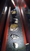
أصبحت هاپيسبرگ موقعاً أثرياً هاماً على المستوى الوطني في 2010 عندما عُثر فيها على أدوات من حجر الصوان تعود إلى أكثر من 800.00 سنة. ويعتبر هذا أقدم دليل على إقامة البشر في المملكة المتحدة.[4]
الحكم
الخصائص المحلية
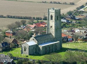
كنيسة سانت مارك
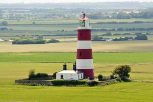
الفنار 2
محطة لايفبوت

Happisburgh lifeboat station and RNLI shop.
قصر هاپيسبرگ أو سانت ماري
التعرية الساحلية
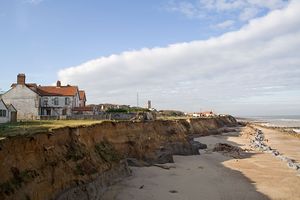
The view of the cliffs from the end of Beach Road showing the precarious position of several houses, as the cliffs are being eaten away by coastal erosion.
علم الآثار
في 7 فبراير 2014 أفاد علماء الآثار أن وقع الأقدام البشرية، الذي يمكن أن تكون من أسلاف البشر، قد يبلغ عمرها 1 مليون سنة، وقد عُثر عليها في هاپيسبرگ، شرق إنگلترة، في مايو 2013.[5][6][7][8]
الفلكلور
أشهر أبناء هاپيسبرگ
- تشارلز وليام پيتش، عالم طبيعة، وجيولوجي
- ريتشارد پورسون، باحث كلاسيكي
انظر أيضاً
- التاريخ الوراثي للجزر البريطانية
- قائمة أحفورات التطور البشري
- قائمة منشآت ما قبل التاريخ في بريطانيا العظمى
- بريطانيا ما قبل التاريخ
- List of places in England with counterintuitive pronunciations: A–L
Local offshore sandbanks dangerous to shipping:
المصادر والهوامش
- المصادر
- ^ Census population and household counts for unparished urban areas and all parishes. Office for National Statistics & Norfolk County Council (2001). Retrieved 20 June 2009.
- ^ Key Statistics: Population. (2011 census) Retrieved 2015-02-27.
- ^ Ordnance Survey (2002). OS Explorer Map 252 - Norfolk Coast East. ISBN 0-319-21888-0.
- ^ Miriam Frankel. "Early Britons could cope with cold : Nature News". Nature.com. Retrieved 13 November 2012.
- ^ Lawless, Jill (7 February 2014). "Scientists find 800,000-year-old footprints in UK". AP News. Retrieved 7 February 2014.
- ^ Ghosh, Pallab (7 February 2014). "Earliest footprints outside Africa discovered in Norfolk". BBC. Retrieved 7 February 2014.
- ^ Ashton, N; Lewis, SG; De Groote, I; Duffy, SM; Bates, M; Hoare, Peter; Lewis, Mark; Parfitt, Simon A.; Peglar, Sylvia; Williams, Craig; Stringer, Chris; et al. (2014). "Hominin Footprints from Early Pleistocene Deposits at Happisburgh, UK". PLoS ONE. 9 (2): e88329. doi:10.1371/journal.pone.0088329. PMC 3917592. PMID 24516637.
{{cite journal}}: Explicit use of et al. in:|author6=(help); Unknown parameter|displayauthors=ignored (|display-authors=suggested) (help)CS1 maint: unflagged free DOI (link) - ^ Ashton, Nicholas (7 February 2014). "The earliest human footprints outside Africa". المتحف البريطاني. Retrieved 7 February 2014.
- الهوامش
- ^ Thus HAYZ-bur-ə north of foot-strut split (isogloss) or HAYZ-buh-rə sometimes south.
وصلات خارجية
- Map sources for هاپيسبرگ
- Information from Genuki Norfolk on Happisburgh.
- CCAG Happisburgh Coastal Concern Action Group.
- Happisburgh Literary History
- British Geological Survey case study of coastal erosion at Happisburgh
- British Museum, Happisburgh: The earliest humans in northern Europe
الكلمات الدالة:
This article contains content from Wikimedia licensed under CC BY-SA 4.0. Please comply with the license terms.
تصنيفات:
- CS1 errors: unsupported parameter
- CS1 maint: unflagged free DOI
- Articles with OS grid coordinates
- Pages using infobox UK place with unknown parameters
- Pages including recorded pronunciations
- Articles with hatnote templates targeting a nonexistent page
- شمال نورفولك
- قرى نوروفولك
- أماكن ساحلية مأهولة في نوروفولك
- ابراشيات مدنية في نوروفولك
- مواقع من العصر الحجري في إنگلترة
- شواطئ نورفولك
