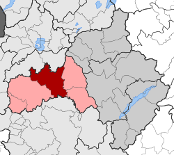
نياپولي، كوزاني
Neapoli
Νεάπολη | |
|---|---|
| الإحداثيات: 40°18′N 21°24′E / 40.300°N 21.400°E | |
| البلد | |
| المنطقة الادارية | West Macedonia |
| الوحدة المحلية | Kozani |
| البلدية | Voio |
| • الوحدة البلدية | 238٫227 كم² (91٫980 ميل²) |
| المنسوب | 669 m (2٬195 ft) |
| التعداد (2011)[1] | |
| • الوحدة البلدية | 4٬100 |
| • كثافة الوحدة البلدية | 17/km2 (45/sq mi) |
| Community | |
| • التعداد | 2٬325 (2011) |
| • المساحة (كم²) | 22.001 |
| منطقة التوقيت | UTC+2 (EET) |
| • الصيف (التوقيت الصيفي) | UTC+3 (EEST) |
| Postal code | 500 01 |
| مفتاح الهاتف | 24680 |
| Vehicle registration | KZ |
نياپولي (باليونانية: Νεάπολη؛ Neapoli) هي بلدة وبلدية سابقة في الوحدة المحلية كوزاني في غرب مقدونيا في اليونان. ومنذ الإصلاح الاداري في 2011، فقد أصبحت جزءاً بلدياً من بلدية ڤويو.[2]
تبلغ مساحة الوحدة البلدية 238.277 كم²، بينما مساحة التجمع السكاني 22.001 كم².[3] الوحدة البلدية يبلغ عدد سكانها 4,100 نسمة، بينما لاتجمع يضم 2,323 نسمة (2011).[1] Present-day Neapoli was once known as the ancient town of Palladium. In the Ottoman period it was named Anaselítsa or Nasliç [4] and had a large population of Albanian Muslims and Greek Muslims referred to by locals as Vallahades.
. . . . . . . . . . . . . . . . . . . . . . . . . . . . . . . . . . . . . . . . . . . . . . . . . . . . . . . . . . . . . . . . . . . . . . . . . . . . . . . . . . . . . . . . . . . . . . . . . . . . . . . . . . . . . . . . . . . . . . . . . . . . . . . . . . . . . . . . . . . . . . . . . . . . . . . . . . . . . . . . . . . . . . . .
References
- ^ أ ب ت "Απογραφή Πληθυσμού - Κατοικιών 2011. ΜΟΝΙΜΟΣ Πληθυσμός" (in اليونانية). Hellenic Statistical Authority.
- ^ Kallikratis law Greece Ministry of Interior (in Greek)
- ^ "Population & housing census 2001 (incl. area and average elevation)" (PDF) (in اليونانية). National Statistical Service of Greece.
- ^ State-Nationalisms in the Ottoman Empire, Greece and Turkey Benjamin C. Fortna, Stefanos Katsikas, Dimitris Kamouzis, Paraskevas Konortas Routledge, 27.11.2012

