نهر يانة
| Guadiana River Rio Guadiana | |
|---|---|
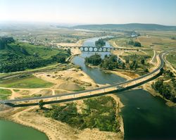
 The Guadiana River in the area around Serpa, Portugal | |
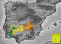
 About 83 percent, 55,000 square kilometres (21,000 sq mi), of the River Guadiana watershed is in Spain; the rest is in Portugal (interactive map) | |
| أصل الاسم | Arabic derivative of Wādī + Ana, meaning "River Ana" |
| الموقع | |
| البلد | Portugal, Spain |
| السمات الطبيعية | |
| المنبع | Ojos del Guadiana |
| ⁃ الموقع | Villarrubia de los Ojos, Castile–La Mancha, Spain |
| ⁃ الإحداثيات | 39°7′36″N 3°43′36″W / 39.12667°N 3.72667°W |
| ⁃ المنسوب | 608 متر |
| المصب | Gulf of Cádiz |
- الموقع | Vila Real de Santo António, Algarve, Portugal |
- الإحداثيات | 37°10′12″N 7°23′37″W / 37.17000°N 7.39361°W |
- المنسوب | 0 متر |
| الطول | 818 km (508 mi) |
| مساحة الحوض | 67,733 km2 (26,152 sq mi) |
| العمق | |
| - الأدنى | 5 m (16 ft) |
| - الأقصى | 17 m (56 ft) |
| التدفق | |
| ⁃ المتوسط | 78.8 m3/s (2,780 cu ft/s) |
| ⁃ أدنى تدفق | 20 m3/s (710 cu ft/s) |
| ⁃ أقصى تدفق | 1,500 m3/s (53,000 cu ft/s) |
| سمات الحوض | |
| الروافد | |
| - اليسرى | |
| - اليمنى | |
 | |
نهر يَانَة[1] أو نهر بَطَلْيُوس[2] (من اللاتينية: Fluminus Anae، وهو حاليًا بالإسبانية: Guadiana) ( /ˌɡwɑːdiˈɑːnə/, also الأمريكي /ɡwɑːdˈjɑːnə/,[3][4] النطق الإسپاني: [ɡwaˈðjana], البرتغالية: [ɡwɐðiˈɐnɐ]), or Odiana هو أعرض نهر بشبه الجزيرة الأيبيرية، ينبع من وسط إسبانيا ويصب في المحيط الأطلسي على الحدود الإسبانية البرتغالية. يبلغ طوله 742 كم، ويفصل Extremadura and Andalusia (Spain) from Alentejo and Algarve (Portugal). The river's basin extends from the eastern portion of Extremadura to the southern provinces of the Algarve; the river and its tributaries flow from east to west, then south through Portugal to the border towns of Vila Real de Santo António (Portugal) and Ayamonte (Spain), where it flows into the Gulf of Cádiz. With a course that covers a distance of 829 kilometres (515 mi), it is the fourth-longest in the Iberian peninsula, and its hydrological basin extends over an area of approximately 68,000 square kilometres (26,000 sq mi) (the majority of which lies within Spain).
. . . . . . . . . . . . . . . . . . . . . . . . . . . . . . . . . . . . . . . . . . . . . . . . . . . . . . . . . . . . . . . . . . . . . . . . . . . . . . . . . . . . . . . . . . . . . . . . . . . . . . . . . . . . . . . . . . . . . . . . . . . . . . . . . . . . . . . . . . . . . . . . . . . . . . . . . . . . . . . . . . . . . . . .
أصل الاسم
The Romans referred to the river as the Flumen Anas, the "River of Ducks". During the Moorish occupation and settlement, the name was extended and referred to as Wadi Ana (wādī being the Arab term for "river"), later passed on to Portuguese and Spanish settlers as the Ouadiana, and later just Odiana. Since the 16th century, due to Castilian influences, the name has slowly evolved to take on the form Guadiana, a cognitive variation that developed from many Moorish-Arab river place-names using the prefix guad- (such as the rivers Guadalquivir, Guadalete, Guadalajara or Guadarrama).
الحوض

The Guadiana flows east to west through Spain and south through Portugal, then forms the Spanish-Portuguese border; it flows into the Gulf of Cádiz, part of the Atlantic Ocean, between Vila Real de Santo António (Portugal) and Ayamonte (Spain). It is 818 kilometres (508 mi) long, of which 578 kilometres (359 mi) are within Spanish territory, 140 kilometres (87 mi) within Portugal, while 100 kilometres (62 mi) are shared between the two nations. About 82 percent, 55,444 square kilometres (21,407 sq mi), of its basin is in Spain, while about 17 percent, 11,560 square kilometres (4,460 sq mi) is in Portugal.[5]
المصادر
The exact source of the river in Castilla-La Mancha is disputed, but it is generally believed to spring in the Ojos del Guadiana, Villarrubia de los Ojos municipal term, Ciudad Real Province, Castile–La Mancha, about 608 metres (1,995 ft) in elevation.
السدود
There are over 30 dams on the river basin. The following are the dams on the Guadiana river itself:[6]
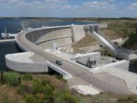
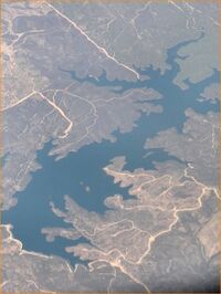
- Alqueva Dam, the largest dam, located near Moura, in the Beja District, responsible for the largest reservoir in Western Europe. (There are several larger ones in Russia and Ukraine.) The Alqueva reservoir, occupies an area of 250 square kilometres (97 sq mi), with a capacity for 4,150 cubic hectometres (3,360,000 acre⋅ft).[بحاجة لمصدر]
- García Sola Reservoir
- Cíjara Reservoir
- El Vicario Reservoir
- Orellana Reservoir
انظر أيضاً
المراجع
- الهامش
- ^ «نهر يانة وهو نهر ماردة وبطليوس، وعليه حصن مارتلة المشهور بالمنعة والحصانة». الإدريسي، نزهة المشتاق في اختراق الآفاق.
- ^ «مارتلة: على نهر بطليوس بجزيرة الأندلس، منها الزاهد موسى بن عمران المارتلي، اشتهر في إشبيلية بالصلاح». الحميري، الروض المعطار في خبر الأقطار.
- ^ "Guadiana". Collins English Dictionary. HarperCollins. Retrieved 30 May 2019.
- ^ "Guadiana". Oxford Living Dictionaries. Oxford University Press. Archived from the original on 30 May 2019. Retrieved 30 May 2019.
- ^ Aldaya & Llamas 2009, p. 6.
- ^ Dams on the Guadiana Basin.
- المصادر
- Díaz-Pintado Carretón, José (1997). D.L. Soubriet (ed.). El polémico Guadiana: historia y leyenda del río Guadiana Alto [The Guadiana Controversy: History and Legend of the Upper Guadiana River]. Ciudad Real, Spain: Argamasilla de Alba. ISBN 84-922069-9-3.
- Alonso, A. Cabo (1990). "Guadiana". Madrid, Spain: Railp. Archived from the original on 16 يوليو 2011. Retrieved 2 يوليو 2010.
- Chícharo, Luis; Chícharo, Alexandra; Ben-Hamadou, Radhouane; Morais, Pedro (2007). "The Guadiana Estuary". In Caroline King (ed.). Water and Ecosystems: Managing Water in Diverse Ecosystems to Ensure Human Well-being (PDF). Hamilton, Ontario: The United Nations University. pp. 108–117. Archived from the original (PDF) on 12 June 2010. Retrieved 2 July 2010.
- Aldaya, Maite M.; Llamas, M. Ramón (2008). "Water Footprint Analysis for the Guadiana River Basin". Papeles de água Virtual (PDF). Vol. 3. Madrid, Spain: Fundación Marcelino Botín, Realigraf, S.A. ISBN 978-84-96655-23-2. Archived from the original (PDF) on 3 March 2016. Retrieved 2 July 2010.
- García, Cristóbal García (2003). "Results overview for the Guadiana River Basin (Spain)". WWF Water and Wetland Index – Critical issues in water policy across Europe (PDF). Madrid, Spain: WWF (World Wildlife Fund) Spain.
- Aldaya, M.M.; Llamas, M.R. (2009). "Water footprint analysis (hydrologic and economic) of the Guadiana river". Report to the U.N. World Water Development Report No. 3 to be presented during the 5th World Water Forum (PDF). Istanbul, Turkey: Real Academia de Ciencias Exactas, Físicas y Naturales. pp. 1–77.
وصلات خارجية
- Pages using gadget WikiMiniAtlas
- Short description is different from Wikidata
- Articles with hatnote templates targeting a nonexistent page
- Coordinates on Wikidata
- Articles containing لاتينية-language text
- Articles with unsourced statements from April 2015
- يانة
- Natura 2000 in Portugal
- أنهار إسپانيا
- أنهار البرتغال
- صفحات مع الخرائط


