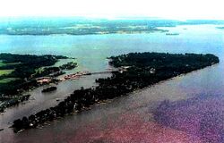
نهر ويكوميكو (رافد نهر پوتوماك)
| Wicomico River | |
|---|---|
 جزيرة كوب، مريلاند تقع عند التقاء Neale Sound، نهر ويكوميكو و نهر پوتوماك | |
| الموقع | |
| البلد | الولايات المتحدة |
| State | مريلاند |
| السمات الطبيعية | |
| المصب | |
- الموقع | نهر پوتوماك |
- المنسوب | 0 feet (0 m) |
| الطول | 13.0 miles (20.9 km) |
 | |
نهر ويكوميكو Wicomico River هو رافد يبلغ طوله 20.9 كم[1] للجزء المدِّي السفلي لـ نهر پوتوماك الواقع في ولاية مريلاند جنوب واشنطن العاصمة. The river empties into the Potomac at Cobb Island and St. Margaret's Island. Its watershed area (excluding water) is 77 square miles (200 km2), with 2% impervious surface in 1994[2] in Charles, St. Mary's, and southern Prince George's counties. The lower section of the river forms part of the boundary between Charles and St. Mary's counties. The Wicomico River was designated a Scenic River under the Maryland Scenic River Act in 1968. Scenic River Commissions oversee it in Charles and St. Mary's counties. (see links below).
. . . . . . . . . . . . . . . . . . . . . . . . . . . . . . . . . . . . . . . . . . . . . . . . . . . . . . . . . . . . . . . . . . . . . . . . . . . . . . . . . . . . . . . . . . . . . . . . . . . . . . . . . . . . . . . . . . . . . . . . . . . . . . . . . . . . . . . . . . . . . . . . . . . . . . . . . . . . . . . . . . . . . . . .
الروافد
- Allens Fresh Run
- Willmer Creek
- Cramer Gut
- Posey Creek
- Tears Gut
- Steinhauser Gut
- Bunker Hill Branch
- Foggy Bottoms Gut
- Colby Run
- Newport Marsh Run
- Newport Run
- Hickory Gut
- St. Clair Gut
- Murphy Run
- Hodister Run
- Lloyd Drain
- Bowling Gut
- Budds Creek
- Chaptico Bay
- Chaptico Run
- Burroughs Run
- Bull Run
- Maddox Creek
- Charleston Creek
- Neale Sound
المراجع
- ^ U.S. Geological Survey. National Hydrography Dataset high-resolution flowline data. The National Map Archived 2012-03-29 at the Wayback Machine, accessed August 15, 2011
- ^ Wicomico (on Potomac), MD Surf your watershed, Watershed profile. [1], accessed June 13, 2012
وصلات خارجية
- Wicomico Scenic River Commission--St. Mary's County
- Wicomico Scenic River Commission--Charles County
38°17′12″N 76°49′37″W / 38.28667°N 76.82694°W
خطأ لوا في وحدة:Authority_control على السطر 278: attempt to call field '_showMessage' (a nil value).