نهر روفيجي
| روفيجي | |
|---|---|
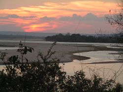
 نهر روفيجي في سلوس | |
 Map of the Rufiji River drainage basin. The separate, endorheic Lake Sulunga basin is shown in green. | |
| الاسم المحلي | Rufiji (كشميري) |
| الموقع | |
| البلد | تنزانيا |
| السمات الطبيعية | |
| المنبع | |
| ⁃ الموقع | Tanzania |
| ⁃ الإحداثيات | 8°31′17″S 37°20′33″E / 8.52139°S 37.34250°E |
| المصب | |
- الموقع | المحيط الهندي |
- الإحداثيات | 7°46′26″S 39°21′50″E / 7.77389°S 39.36389°E |
| الطول | 600 km (370 mi) |
 | |
نهر روفيجي Rufiji River يقع بالكامل داخل تنزانيا. The river is formed by the confluence of the Kilombero and Luwegu rivers. It is approximately 600 كيلومتر (370 mi) long, with its source in southwestern Tanzania and its mouth on the Indian Ocean at a point between Mafia Island called Mafia Channel. Its principal tributary is the Great Ruaha River. It is navigable for about 100 كيلومتر (62 mi).
The Rufiji is about 200 كيلومتر (120 mi) south of Dar es Salaam. The river's delta contains the largest mangrove forest in eastern Africa.[1]
التاريخ
A branch of ancient sea routes led down the East African coast called "Azania" by the Greeks and Romans in the 1st century CE as described in the Periplus of the Erythraean Sea (and, very probably, الصينية: 澤散 in the 3rd century by the Chinese),[2] at least as far as the port known to the Romans as Rhapta, which was probably located in the delta of the Rufiji River in modern Tanzania.[3]
During the First World War, from October 1914 to July 1915, the river delta was the scene of a protracted naval operation. These were the attempts, and later achievement, by the Royal Navy to neutralize and destroy the German cruiser Konigsberg.
الحوض
The catchment basin for the Rufiji River complex is 177،429 متر كيلومربع (68،506 sq mi).[4]
| River | Area km2 |
Percentage of area |
Percentage of run-off |
|---|---|---|---|
| Great Ruaha | 83,970 | 47 | 15 |
| Kilombero | 39,990 | 23 | 62 |
| Luwegu | 26,300 | 15 | 18 |
| Rufiji (lower river) | 27,160 | 15 | 5 |
| Total | 177,429 | 100 | 100 |
مشروع توليد الكهرباء
 مقالة مفصلة: سد روفيجي
الرئيس التنزاني جون ماگوفولي أعطى موافقته على إنشاء محطة خانق شتيگلر لتوليد الطاقة المائية (سد روفيجي) الجديدة بقدرة 2,115 مـِگاواط على النهر في المنطقة.[5] وسينتج عن هذه الخطوة الجديدة كهرباء إضافية قدرها 2,100 مـِگاواط ، والتي تعني الزيادة لثلاثة أضعاف قدرة تنزانيا من الطاقة المائية التي تقف حاليا عند 562 مـِگاواط.[6] المشروع يقوم بتنفيذه شركتان مصريتان، المقاولون العرب والسويدي للكابلات. وقد بدأ العمل في تنفيذ المشروع في 26 يوليو 2019 وسيكون جاهزاً في 2022.
المراجع
- ^ "Downstream and Coastal Impacts of Damming and Water Abstraction in Africa", Environmental Management, authored by Maria Snoussi, Johnson Kitheka, Yohanna Shaghude, Alioune Kane, Russell Arthurton, Martin Le Tissier, and Hassan Virji, 2007, volume 39, page 589
- ^ "The Peoples of the West". from the Weilue 魏略 by Yu Huan 魚豢. Translated by Hill, John E. University of Washington. September 2004. Retrieved 2009-04-18.
- ^ "The Egypto-Graeco-Romans and Panchea/Azania: sailing in the Erythraean Sea." Felix A. Chami. In: Society for Arabian Studies Monographs 2 Trade and Travel in the Red Sea Region. Proceedings of Red Sea Project I held in the British Museum October 2002, pp. 93-104. Edited by Paul Lunde and Alexandra Porter. ISBN 1-84171-622-7.
- ^ Arvidson, Anders; et al. (May 2009). "Initial Assessment of Socioeconomic and Environmental Risks and Opportunities of Large-scale Biofuels Production in the Rufiji District" (PDF). SEKAB BioEnergy (T) Ltd. p. 23.
- ^ "Tanzania to Construct Hydropower Plant on National Reserve". Voice of America. July 26, 2019.
- ^ "Tanzania launches Rufiji power plant". The EastAfrican. July 26, 2019.
للاستزادة
- Chami, F. A. 1999. "The Early Iron Age on Mafia island and its relationship with the mainland." Azania Vol. XXXIV 1999, pp. 1–10.
- Chami, Felix A. 2002. "The Egypto-Graeco-Romans and Panchea/Azania: sailing in the Erythraean Sea." In: Society for Arabian Studies Monographs 2 Trade and Travel in the Red Sea Region. Proceedings of Red Sea Project I held in the British Museum October 2002, pp. 93–104. Edited by Paul Lunde and Alexandra Porter. ISBN 1-84171-622-7.
- Miller, J. Innes. 1969. Chapter 8: "The Cinnamon Route". In: The Spice Trade of the Roman Empire. Oxford: University Press. ISBN 0-19-814264-1
- Ray, Himanshu Prabha, ed. 1999. Archaeology of Seafaring: The Indian Ocean in the Ancient Period. Pragati Publications, Delhi.
وصلات خارجية
- Pages using gadget WikiMiniAtlas
- Short description is different from Wikidata
- Articles containing كشميري-language text
- Coordinates on Wikidata
- Infobox mapframe without OSM relation ID on Wikidata
- Pages using infobox river with unknown parameters
- Articles containing Chinese-language text
- روفيجي، نهر
- أنهار تنزانيا
- صفحات مع الخرائط