نهر خرامي
| Khrami آذربيجاني: Anaxatır | |
|---|---|
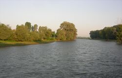
 The Khrami near Kirach Muganlo, Georgia | |
 | |
| الاسم المحلي | Error {{native name}}: an IETF language tag as parameter {{{1}}} is required (help) |
| الموقع | |
| Countries | Georgia and Azerbaijan |
| Region | Caucasus |
| السمات الطبيعية | |
| المنبع | Lesser Caucasus |
| ⁃ الموقع | Trialeti Range, جورجيا |
| المصب | Kura |
- الموقع | Muğanlı, Agstafa, Azerbaijan |
- الإحداثيات | 41°18′55″N 45°07′31″E / 41.31528°N 45.12528°E |
| الطول | 201 km (125 mi) |
| التدفق | |
| ⁃ الموقع | directly downstream into Kura |
| سمات الحوض | |
| السريان | كورا ← بحر قزوين |
| الروافد | |
| - اليسرى | Debed, Mashavera |
 | |
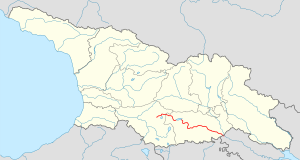
خرامي (Khrami ؛ بالجورجية: ხრამი, آذربيجاني: Anaxatır "أناخاطر")، في أعاليه Ktsia، هو نهر في شرق جورجيا وغرب أذربيجان, and a right tributary of the Kura (Mtkvari). It is 201 km (125 mi) long, and has a drainage basin of 8,340 km2 (3,220 sq mi).[1][2] The Khrami originates in the Trialeti Range and flows into a deep valley. It is fed primarily by snow. Its main tributaries are the Debed and Mashavera rivers. The Tsalka Reservoir and three hydroelectric power plants are built on the Khrami.
. . . . . . . . . . . . . . . . . . . . . . . . . . . . . . . . . . . . . . . . . . . . . . . . . . . . . . . . . . . . . . . . . . . . . . . . . . . . . . . . . . . . . . . . . . . . . . . . . . . . . . . . . . . . . . . . . . . . . . . . . . . . . . . . . . . . . . . . . . . . . . . . . . . . . . . . . . . . . . . . . . . . . . . .
انظر أيضاً
المراجع
- ^ Statistical Yearbook of Georgia: 2020, National Statistics Office of Georgia, Tbilisi, 2020, p. 12.
- ^ Храми, Great Soviet Encyclopedia
- Pages using gadget WikiMiniAtlas
- Short description is different from Wikidata
- Articles containing آذربيجاني-language text
- Pages using Lang-xx templates
- Native name template errors
- Coordinates on Wikidata
- روافد نهر كورا (بحر قزوين)
- Articles containing جورجية-language text
- Rivers of Georgia (country)
- Rivers of Azerbaijan
- International rivers of Asia
- International rivers of Europe
- صفحات مع الخرائط