نقاش القالب:Geobox/River
| الأمازون | |
| Apurímac, Ene, Tambo, Ucayali, Amazonas, Solimões | |
| River | |
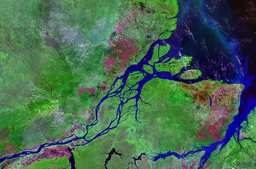
فم نهر الأمازون
| |
| البلدان | |
|---|---|
| الروافد | |
| - يسار | Marañón, Japurá, Rio Negro |
| - يمين | Purus, Madeira, Tapajós, Xingu, Tocantins |
| Source | Apacheta cliff |
| - الموقع | Nevado Mismi, Arequipa, Peru |
| - elevation | 5,170 m (16,962 ft) |
| - coordinates | 15°31′05″S 71°45′55″W / 15.51806°S 71.76528°W |
| المصب | |
| - الموقع | Atlantic Ocean, Brazil |
| - الارتفاع | 0 m (0 ft) |
| الطول | 6,400 km (4,000 mi) approx. |
| الحوض | 7,050,000 km2 (2,720,000 sq mi) approx. |
| التدفق | for mouth |
| - المتوسط | 219,000 m3/s (7,734,000 cu ft/s) approx. |
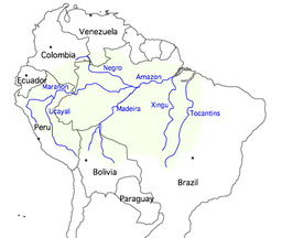
Map showing the course of the Amazon, selected tributaries, and the approximate extent of its drainage area
| |

