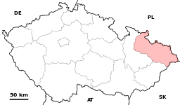
نقاش القالب:Geobox/Region
| Moravian-Silesian (Moravskoslezský) | |||
| Region | |||
|
|||
| البلد | Czech Republic | ||
|---|---|---|---|
| العاصمة | Ostrava | ||
| - center | Masarykovo náměstí | ||
| - الارتفاع | 260 m (853 ft) | ||
| - الإحداثيات | 49°50′8″N 18°17′33″E / 49.83556°N 18.29250°E | ||
| أعلى نقطة | Praděd | ||
| - المنسوب | 1,491 m (4,892 ft) | ||
| أوطى نقطة | |||
| - المنسوب | 195 m (640 ft) | ||
| المساحة | 5,445 km2 (2,102 sq mi) | ||
| التعداد | 1٬251٬883 (2006) | ||
| الكثافة | 230/km2 (596/sq mi) | ||
| Hetman | Evžen Tošenovský (ODS) | ||
| ISO 3166-2 | CZ-MO | ||
| Licence plate | T | ||
| الموقع: www.kr-moravskoslezsky.cz | |||


