منتزه ميكومي الوطني
| منتزه ميكومي الوطني | |
|---|---|
IUCN category II (national park) | |
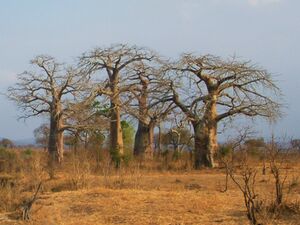
 منظر من منتزه ميكومي الوطني. | |
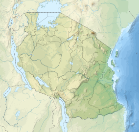
| الموقع | ميكومي بالقرب من موروگورو، تنزانيا. |
| أقرب مدينة | دار السلام |
| الإحداثيات | 7°12′S 37°08′E / 7.200°S 37.133°E |
| المساحة | 3.230 كم² |
| تأسست | 1964 |
| الزوار | 41.666 (in 2012[1]) |
| الهيئة الحاكمة | هيئة المنتزهات الوطنية في تنزانيا (TANAPA) |
| الموقع الإلكتروني | www |
منتزه ميكومي الوطني (Mikumi National Park)، هو منتزه وطني يقع بالقرب من موروگورو، تنزانيا بمساحة 3.230 كم². تأسس المنتزه عام 1964، وهو رابع أكبر منتزه في البلاد. يتم عبور الحديقة بواسطة الطريق السريع A-7 في تنزانيا.
. . . . . . . . . . . . . . . . . . . . . . . . . . . . . . . . . . . . . . . . . . . . . . . . . . . . . . . . . . . . . . . . . . . . . . . . . . . . . . . . . . . . . . . . . . . . . . . . . . . . . . . . . . . . . . . . . . . . . . . . . . . . . . . . . . . . . . . . . . . . . . . . . . . . . . . . . . . . . . . . . . . . . . . .
الأراضي
Mikumi National Park borders Selous Game Reserve on the south, the two areas forming a unique ecosystem. Two other natural areas bordering the national park are the Udzungwa Mountains and Uluguru Mountains. Malundwe Mountain is within the park, the highest of a belt of hills that run east and west through the park, connecting the Uluguru Mountains to the northeast with the Uvidunda and Udzungwa mountains to the west. Malundwe Mountain consists of three peaks along a ridge running north and south. Malundwe's south peak is the highest point in the park, reaching 1290 meters elevation.[2]
الحياة النباتية والحيوانية
The landscape of Mikumi is often compared to that of the Serengeti. The road that crosses the park divides it into two areas with partially distinct environments. The area north-west is characterized by the alluvial plain of the river basin Mkata. The vegetation of this area consists of savannah dotted with acacia, baobab, tamarinds, and some rare palm. In this area, at the furthest from the road, there are spectacular rock formations of the mountains Rubeho and Uluguru. The southeast part of the park is less rich in wildlife, and not very accessible.[بحاجة لمصدر]
The fauna includes many species characteristic of the African savannah. The park contains a subspecies of giraffe that biologists consider the link between the Masai giraffe and the reticulated giraffe. Other animals in the park are elephants, zebras, impala, eland, kudu, black antelope, baboons, wildebeests and buffaloes. At about 5 km from the north of the park, there are two artificial pools inhabited by hippos. More than 400 different species of birds also inhabit the park.[بحاجة لمصدر]
المصادر
- ^ "Tanzania National parks Corporate Information". Tanzania Parks. TANAPA. Archived from the original on 20 December 2015. Retrieved 22 December 2015.
- ^ (2007) "A description and evaluation of Malundwe Mountain forest in Mikumi National Park, Tanzania" in 6th Tanzania Wildlife Research Institute (TAWIRI) Scientific Conference..
وصلات خارجية
- Pages using gadget WikiMiniAtlas
- Short description is different from Wikidata
- IUCN Category II
- Coordinates on Wikidata
- مقالات ذات عبارات بحاجة لمصادر
- غابات شجرية في ميومبو الشرقية
- منتزهات وطنية في تنزانيا
- مناطق محمية تأسست في 1964
- تأسيسات 1964 في تنزانيا
- جغرافيا منطقة موروگورو
- معالم سياحية في منطقة موروگورو
- مناطق طيور هامة في تنزانيا

